An exceptional 1945 detail map of Victoria Harbor and City, Hong Kong, issued by the U.S. Army's 64th Engineer Base Topographic Battalion near the end of World War II, when Hong Kong was still suffering under the Japanese Occupation.
A Closer Look
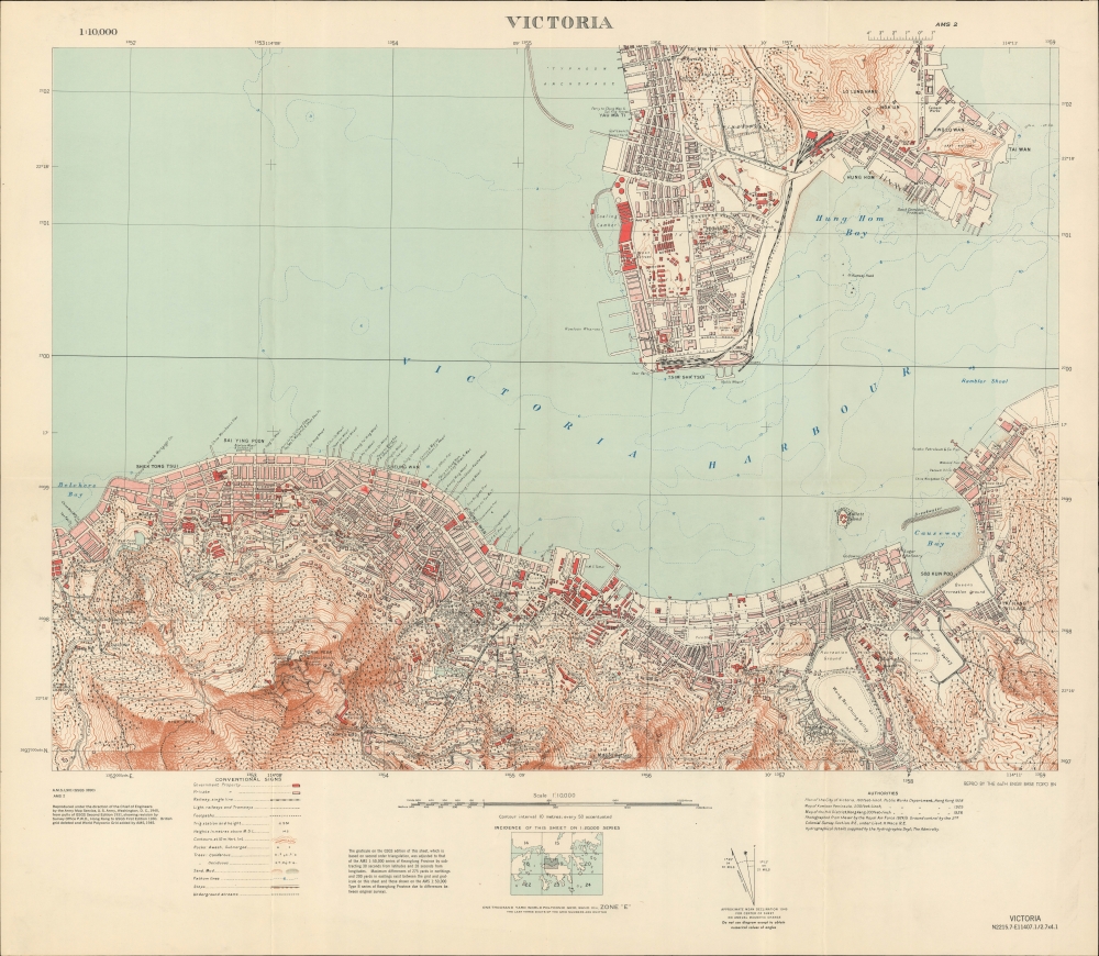
The map is based on earlier British military and colonial surveys dating to the 1920s and early 1930s. Coverage embraces Victoria and Kowloon, collectively the most urbanized part of Hong Kong, stretching from Belcher's Bay to Causeway Bay, inland to include the Peak, and north incorporating Kowloon as far as Tai Min Tin / Waterloo Road. It is meticulously accurate, detailing topography, individual buildings, piers, municipal buildings, forests, railroad lines, major businesses, and more.The Occupation of Hong Kong
During World War II, Hong Kong was under Imperial Japanese occupation, which began on December 25, 1941, following the city's surrender after 18 days of fierce fighting. The Occupation lasted until the end of World War II (1939 - 1945) spanning 3 years, 8 months. The Battle of Hong Kong was among the first battles of the Pacific War, coinciding with the bombing of Pearl Harbor. Despite strong port-side defense capabilities, Hong Kong's garrison, composed of British, Indian, and Canadian units along with Auxiliary Defence Units and the Hong Kong Volunteer Defence Corps, was quickly overwhelmed, leading to the surrender of the colony. The Japanese Occupation was marked by martial law and severe human rights abuses, including brutality, famine, malnourishment, and sickness in internment camps. The Occupation ended with the surrender of Japan following the dropping of Atomic bombs on Hiroshima and Nagasaki. British troops returned to Hong Kong on August 30, 1945.Publication History and Census
This map was created by the U.S. Army's 64th Engineer Base Topographic Battalion in 1945, likely shortly before Japan's surrender on August 30. Rare. Its extreme rarity may be accounted for by the fact that the war ended shortly after it was issued, making the map redundant. We have not identified any other surviving examples.
Cartographer
64th Engineer Base Topographic Battalion (fl. c. 1941 - 1971) was the primary cartographic arm of the U.S. Army in Asia during World War II (1939 - 1945) and the Korean War. Beginning in the Pacific during the First World War, 64th Engineer Topo pioneered modern aerial mapping, producing thousands of maps of little-known and previously unmapped islands - among them Iwo Jima. They also leveraged existing cartography to update and reproduce relevant historical maps. Their efforts were instrumental in the American recapture of the Philippines, the occupation of Japan, and throughout the Korean War. Operations spanned across multiple countries, including Libya, Iran, Ethiopia, and Liberia, showcasing their adaptability and the crucial nature of their work in challenging environments. The unit was disbanded in the early 1970s when satellite mapping made their work obsolete. More by this mapmaker...
Very good. Slight wear on original folds.