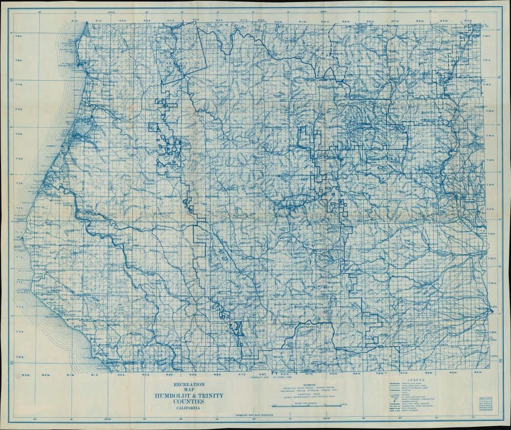
Title
Recreation Map Humboldt and Trinity Counties California showing Principal Auto Roads, Wagon Roads, Railroads, Trails, Streams, Towns, etc.
1907 (undated)
25 x 30 in (63.5 x 76.2 cm)
1 : 15840
Description
A scarce c. 1907 folding map of Humboldt and Trinity Counties, northern California, issued by the Atlas Service and Reproduction Company. It captures the region soon after the establishment of Trinity and Shasta National Forests in 1905.
A Closer Look
Coverage includes Humboldt and Trinity Counties in northern California (minus the northwesternmost portion of Humboldt County around Orick), along with portions of Shasta, Mendocino, and Siskiyou Counties. This area is the core of the 'Redwood Empire,' so named because it is dominated by redwood forests, including old growth. Humboldt County alone contains some forty percent of California's old growth redwood forests.
A grid formed by numbered survey lines appears throughout. Roads (both automobile and wagon roads), railroad lines, waterways, Forest Service facilities and outposts, mountains, administrative boundaries, cities and towns, ranches, and other features are noted in great detail. Along the coast, rocks, lighthouses, and navigational landmarks are noted. Though cities are sparse, Arcata and Eureka can be seen at left towards top, Redding in Shasta County appears at right, and Weaverville at center towards top-right. Although less famous than other parts of California for its petroleum industry, California's first oil wells were drilled at Petrolia (previously named Mattole for the local native inhabitants), at left towards bottom, in 1865.
Much of the land seen here was and remains public land, originally managed by the General Land Office and then transferred to the Division of Forestry (future U.S. Forest Service) in 1905. Management of the Trinity and Shasta National Forests, also established in 1905, was among the earliest tasks of the new office. The two forests were administratively merged in 1954, forming the largest National Forest in California. A portion of Klamath National Forest also appears in the northern part of Trinity County. As a result of so much land being set aside for protection or forest product industries, Trinity has among the lowest populations of California's counties, under 16,000 people in 2022.
Also prominently noted on the map is the Hupa (Hoopa) Valley Indian Reservation within Humboldt County, centered on the unincorporated community Hupa (Hoopa). The area around Eureka was inhabited by Wiyot people, who were the victims of a horrific massacre at the hands of white settlers on Tuluwat (Indian Island), just off Eureka, in 1860. Further north along the Klamath River from Weitchpec is the Yurok Indian Reservation, today home to California's largest tribal community. Soon after this map's production, Lucy Thompson (Che-na-wah Weitch-ah-wah), a Yurok woman, published the book To The American Indian: Reminisces of a Yurok Woman, which cataloged many Yurok traditions, stories, and ceremonies.
The Trinity River was historically famous for its abundance of salmon and steelhead. Fish populations declined with the arrival of white settlers and fell precipitously after the damming of the Trinity River just north of Lewiston in the early 1960s, forming the reservoir Trinity Lake around the (ghost) town of Minersville seen here. The damming of the Trinity and Upper Sacramento Rivers has been a boon to farmlands further to the south in the Central Valley, but has been continuously opposed by indigenous communities, whose lands and way of life were heavily impacted by the dam projects.Publication History and Census
This map was published by the Atlas Service and Reproduction Company, a seemingly short-lived map publisher whose only other known work was a map of Mt. Tamalpais in Marin County, California. It is undated, but the designation of Trinity and Shasta National Forests indicates a date of 1905 or later, while other information and the style of the map suggest a date not much later than 1910. The only other known example of this map is held by the University of Michigan, which dates it to between 1905 and 1910.
Condition
Very good. Toning and wear along fold lines.
References
OCLC 1379191559.