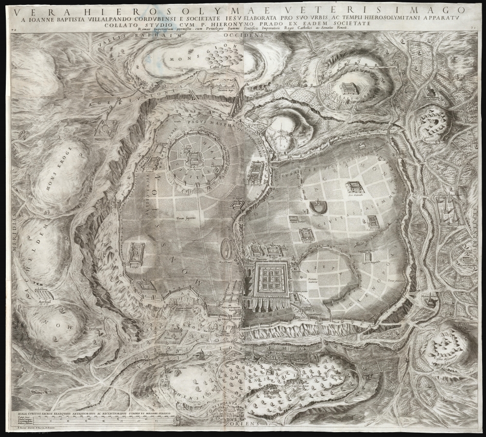
This is Juan Batista Villalpando's large 1604 map of Jerusalem. This attractive and influential plan of the Holy City appeared in his commentary on Ezekiel, published to complete the work of Hieronymus Prado. Villalpando's architectural interpretation of scripture influenced the design of monasteries, churches, and synagogues well into the 17th century.
A Closer Look
The plan, oriented to the west, is based on Villalpando's reading of the Book of Ezekiel and reinforced by the first-century histories of Flavius Josephus. Villalpando added his expertise as a geometer and architect, proposing that Jerusalem and its buildings were constructed based on geometrical laws, thus following divine order. Principle elements include the Temple of Solomon, bottom center, the City of David, upper left, and the historic city wall. Outside the city walls are the encampment of Titus and Pompey, as well as other camps and Biblical monuments. The structure of Solomon's Temple, including the nine square courtyards, are based on Villalpando's interpretation of Ezekiel's prophecy of a Third Holy Temple.
As beautiful and evocative as they were, Villalpando's imaginative illustrations (including this one) ran afoul of the Inquisition, which considered them misinterpretations of scripture. He was, in the end, found innocent of heresy, and his depictions of Jerusalem and the Temple of Solomon had a long-standing influence on the design of monasteries, churches, and even synagogues.Publication History and Census
This plan was engraved to two plates and printed to two sheets, joined for publication: it was included in the Prado and Villalpando Explanationes in Ezechielis et apparatus Urbis ac temple Hierosolymitani, printed in Rome in 1604. The book is well represented in institutional collections, but we see only three examples of this plan listed separately.
Cartographer
Juan Batista Villalpando (1552 - May 22, 1608) was a Spanish priest born to a Serphardic family, a scholar, mathematician, architect, and a member of the Jesuits. He was born in Cordoba; very little is known of his early life and education. He joined the Jesuits in 1575, for whom he served primarily as an architect. (He had studied the field with Juan de Herrera, Philip II's architect.) During his time he designed a number of buildings, including the Cathedral in Baeza. After his ordination, however, he focused on a study of the exegesis of the Old Testament. In 1596 he completed Jerónimo del Prado's commentaries on Ezekiel (this work brought him under suspicion of heresy, but he was found innocent.) Among his works on Ezekiel were reconstructions both of Solomon's Temple and Jerusalem overall, which caught the eye of many mapmakers and illustrators and stayed in circulation for centuries. His depictions were in no way archaeological or based even on contemporary visit, but were based on his interpretation of Biblical text following the assumption that the buildings were drawn according to geometrical law, and based on divine order. More by this mapmaker...
Source
Villalpando, J. B. / Prado, Hieronymus, Explanationes in Ezechielis et apparatus Urbis ac temple Hierosolymitani, (Rome) 1604.
Very good. Margins close but complete. Stain to title at top left, just entering map area. Else excellent.
OCLC 966689718. Laor, E., Maps of the Holy Land: Cartobibliography of Printed Maps, 1475 - 1900, #1148.