Title
Baldwin's Map of Mining Claims, Near Leadville California Mining District, Lake co. Colorado.
1879 (dated)
27.25 x 38.25 in (69.215 x 97.155 cm)
1 : 9600
Description
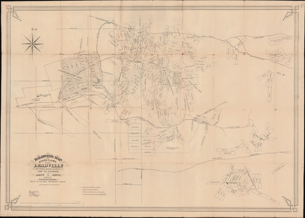
A rare and impressive 1879 Sizer / Baldwin map of Leadville, Colorado, and the California Gulch mining district at the dawn of the Colorado Silver Boom (1879 - 1893). The map reveals a cacophony of overlapping mining claims - underscoring the complexity and lawlessness of American mineral rushes where ambitious prospectors intentionally and unintentionally laid claims to land without official recognition or proper surveys.
A Closer Look
The map covers the California Gulch Mining District roughly between Evans Creek and Iowa Creek, including California Gulch, White's Gulch, and Stray Horse Creek. The town of Leadville is prominent at left, and the ghost town of Oro City appears at right, Adlaide City is between them. In all three towns, streets, smelters, iron works, sampling works, and reduction works are noted. Throughout hundreds of claims are defined, some overlapping, each named. Where claims have been officially registered with a patent, the number is attached. Circles mark producing mines.Leadville, Colorado
Leadville was first settled by gold prospectors in 1859 during the Pike's Peak Gold Rush. They founded the nearby town of Oro City, just to the left of center here. Early miners complained of black sand that clogged the sluice boxes, making gold extraction difficult, until they figured out the said was actual cerussite, a lead mineral with extremely high silver content. Prospector Horace Tabor was quick to recognize that silver, not gold, was the richer discovery. He and August Meyer subsequently founded Leadville in 1877, marking the early days of the Colorado Silver Boom. Prospectors rushed into town, establishing hundreds of claims (as shown here). Within three years, Leadville had gas lighting, water mains, twenty-eight miles of streets, five churches, three hospitals, six banks, and a school for 1,100 students.Colorado Silver Boom
The Colorado Silver Boom officially began in 1879, the year this map was issued, with the discovery of major silver deposits at Leadville. It was Colorado's second great mineral boom, following the 1859 Pike's Peak Gold Rush. Some 82,000,000 dollars in silver was mined during the peak boom years. It was more than just rich silver deposits that fueled the boom. In 1878 Congress passed legislation mandating regular large-scale government purchases of silver bullion, creating a reliable and inflated market. The Silver Boom created enormous wealth in Colorado, fostering the fast development of several cities, including Leadville, Pueblo, and Denver. The excess of silver in the economy lead to the 'Free Silver' debate, which divided eastern coastal states and western mining states. Ultimately, when the Sherman Silver Purchase Act was repealed in 1893, silver bullion lost nearly half its value, precipitating the run on U.S. Treasury gold stock known as the Panic of 1893. The Panic not only ended the Colorado Silver Boom, it also led to a global economic collapse of banks and railroads, staggering loss of individual wealth, and contributed to the destabilization of several countries.Provenance: T. W. Robinson
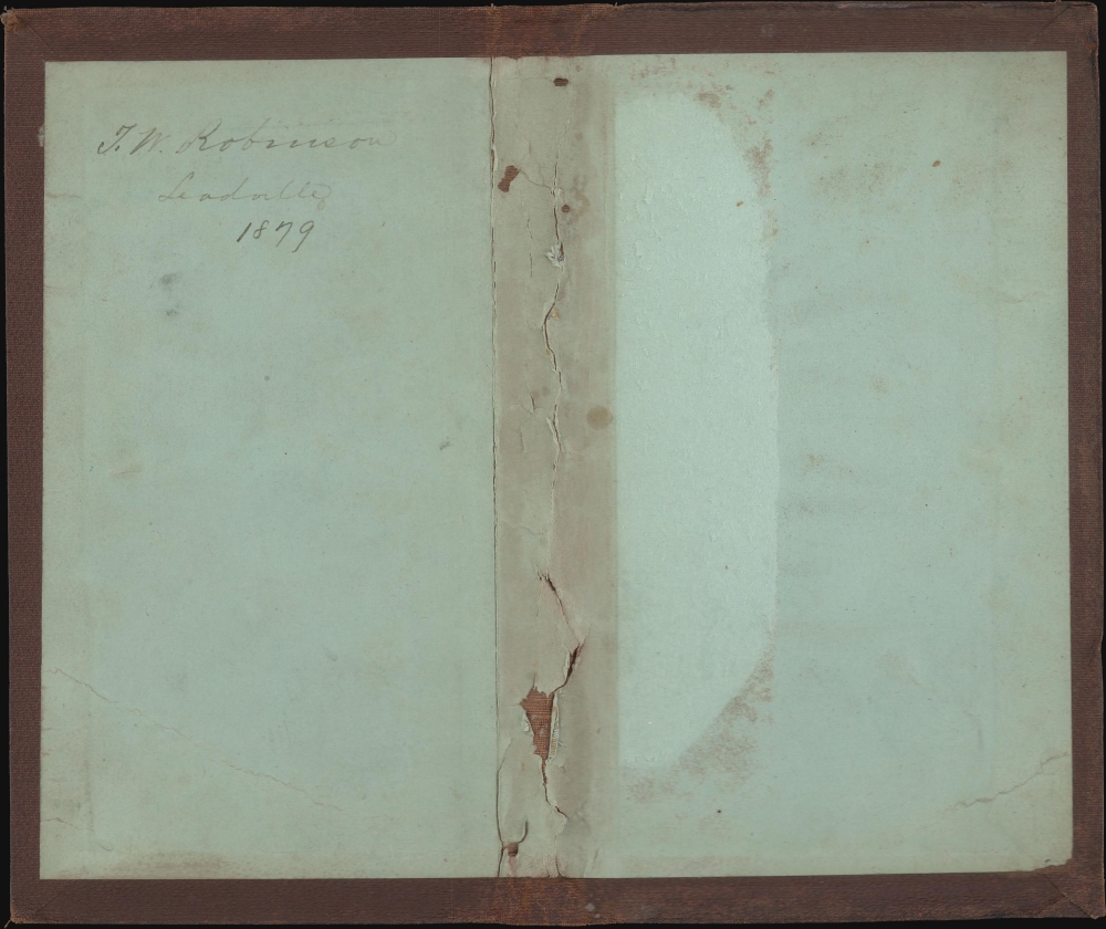
The map accompanies its original binder with the signature of its original owner, T.W. Robinson, inside the front cover. Robinson was a mining engineer who graduated from M.I.T. in 1876. He must have set out to make his fortune in Leadville shortly after graduating. By March 1879, he was supervisor and part owner of the American Mining and Smelting Company, whose works were then under construction. In 1883 we find him in Pueblo, then, in 1884, he relocated to Illinois to become the superintendent of the Joliet Works of Illinois Steel. We find no further record of him.Publication History and Census
This map was issued in January 1879. It was drafted by Frank L. Sizer, and lithographed in Cleveland, Ohio by W. J. Morgan and Company. Published by Baldwin and Company - who we have been unable to pin down. We note examples of this map in eight institutions: the Denver Public Library, the University of Colorado Boulder, Yale University, the Newberry Library (Graff), the University of Michigan, Southern Methodist University (Degolyer), the New York Public Library, and the Huntington Library. Very scarce on the market, with its last appearance being at auction in 2006, where the hammer closed at 6,250 USD.
CartographerS
Frank Leonard Sizer (September 29, 1856 - July 11, 1942) was an American civil and mining engineer active at various sites. He was born Ottawa, Illinois, and studied engineering and surveying at the University of Michigan. On graduating, he moved to Leadville, Colorado, then in the early days of the Colorado Silver Boom (1879 - 1893). He stayed there for several years, mapping mining claims, before relocated to Helena Montana Territory by March of 1882. There he was both a chief clerk in the surveyor general's office, and maintained private business interests. He was a partner in Sizer and Keerl (with James S. Keerl), a Colorado mining concern active from 1890 - 1897. In 1901 he spent a year consulting at the Rosario Mine in Chihuahua, Mexico. He participated at various levels in numerous other mines throughout Montana and was active in various trade organizations. In 1909, he moved to California where in 1942 he died at his home in Berkeley. More by this mapmaker...
Morgan Lithograph (1864 - Present) was founded in 1864 by William J. Morgan (1838 - 1904) and George W. Morgan (1843 - 1905) as W. J. Morgan and Comapny. William was born in Wales and Gorge was born in Pittsburgh, Pennsylvania after the family emigrated. This issued trade cards, broadsheets, maps, pamphlets, postcards, and advertising posters. By the late 1880s, the firm focused almost entirely on colorful large-scale chromolithographs for the circus industry, with Ringling Brothers being their primary client. The name of the firm was simplified to Morgan Lithograph in 18987. They won gold medals at both the 1889 Paris Exposition and the 1893 Columbian Exposition in Chicago for their high quality large-format lithographs. The firm still operates in Cleveland, Ohio. The firm famously produced the political posters for William McKinley's 1896 presidential campaign. In the early 20th century, they segued into film posters for the nascent motion picture company. The firm remains in operation in Cleveland after nearly 160 years. Learn More...
Condition
Good. Some toning and wear on old fold lines with slight loss at some fold intersections. Laid on original linen. Stable. Accompanies original binder.
References
New York Public Library, Map Div. 21-33. OCLC 8085469, 81333946. Phillips (America), page 357.