This copy is copyright protected.
Copyright © 2024 Geographicus Rare Antique Maps
1883 Julius Popper Trade Map: New Orleans to Latin America
LineasNuevaOrleans-popper-1883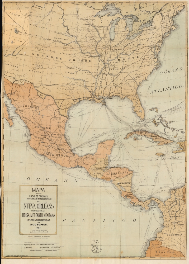


No city in the United States has a deeper interest in the subject of trade with Mexico, Central and South America than New Orleans. The geographical position, combining as it does the advantages of unrivaled interior connections, both by railroad and river, and the facilities of one of the best deep water maritime ports on the continent, indicates this city as such a natural point for handling the incoming and outgoing freights of the vast Mississippi Valley. She is already the second port in the United States for exports, or, combining imports and exports, the third in rank. The expansion of J er commerce with Spanish America will benefit, not herself alone, but every State in the great basin drained by the Mississippi and its tributaries. In natural position New Orleans bears the same relation to St. Louis, Cincinnati, Louisville, Chicago and other great cities of the valley as Liverpool to Manchester, Birmingham and other manufacturing cities of England, and her commerce should have the same relative proportion to that of New York that Liverpool bears to London. The merchandise required for export consists principally of the products of the fields, forests and manufactories of those districts directly in communication with New Orleans by rail and river, while the rapid expansion of Southern Industries is continually increasing the supplies of such articles from the territory more immediately contiguous to her port.
Julius (Julio) Popper (December 15, 1857 - June 5, 1893) was a Romanian-Argentine mechanical engineer, adventurer, and a perpetrator of the Selk'nam genocide. Born in Bucharest he was the son of Neftali Popper, an antique merchant and professor, and Perla (Peppi). Popper left home as early as possible, and went to Paris, where he studied mechanical engineering. After graduating, Popper began his life as an explorer, beginning in Egypt and Turkey, and continuing on through India, China, and Japan, before arriving in the Americas. His exact movements have been lost to history, but we know he arrived in Buenos Aires in 1885, after hearing about the Tierra del Fuego gold rush. After seeing the poor planning that went into the active mining claims, he established his own mining exploration company and struck out to strike it rich. Now known as Julio Popper, his company arrived at San Sebastian Bay in during the second half of 1886 and had mined 154 pounds of gold within the first year. As soon as they arrived, Popper and his men clashed with the native Selk'nam peoples. This led to bloody, uneven battles, and as more settlers arrived (including ranchers), the Selk'nam were even more brutally targeted. Between the hatred of the newcomers and the diseases they brought with them (scarlet fever, smallpox, tuberculosis), the Selk'nam were almost entirely destroyed. Popper didn't stop there. He organized his own private army, and even minted his own coins and issued his own stamps. Incredibly, after the market crash of 1890 destroyed the Argentine peso, Popper's coins were seen as a currency. Popper died suddenly at 35, when he was found poisoned in a Buenos Aires apartment. After his death, his empire collapsed. As an aside, it remains unconfirmed but a rumor persists that Popper designed the modern city of Havana, Cuba. More by this mapmaker...
Michael Fitzgerald Dunn (1842 - March 25, 1913) was a New Orleans Irish-American lithographer and stationer active in the late 19th century. He partnered for a time in the 1879s with Thomas Fitzwilliam from offices at 76 Camp Street, before establishing his own firm, M. F. Dunn and Brothers. They were based at 70 Camp and at 67 Washington Ave, New Orleans. Dunn operated one of the first steam presses in New Orleans. Learn More...
Copyright © 2024 Geographicus Rare Antique Maps | Geographicus Rare Antique Maps
This copy is copyright protected.
Copyright © 2024 Geographicus Rare Antique Maps