1940 Nesbitt Pictorial Map, Monterey Peninsula, California

MontereyPeninsula-nesbitt-1940
$400.00
Map of Monterey Peninsula. - Main View
Processing...

1940 Nesbitt Pictorial Map, Monterey Peninsula, California

MontereyPeninsula-nesbitt-1940

'Where the mountain looks on the forest and the forest looks on the sea.'
$400.00

Title


Map of Monterey Peninsula.
  1940 (undated)     9 x 15 in (22.86 x 38.1 cm)

Description


A charming c. 1940 pictorial view of the Monterey Peninsula by Philip L. Nesbitt, focusing on the Seventeen Mile Drive, the Del Monte Hotel, Pebble Beach, and other local attractions.
A Closer Look
Oriented roughly to the north-northeast, this view takes in the Monterey Peninsula, including the towns of Monterey, Pacific Grove, and Carmel-by-the-Sea. The road outlined in red is the renowned Seventeen Mile Drive. Several golf courses are noted, including the Pebble Beach Golf Course in the foreground. Towards top-right is the Hotel Del Monte, a large resort complex that was a novelty when constructed in 1880 by Charles Crocker, one of California's 'Big Four' railroad tycoons. The verso includes information on the hotel and the area, as well as another pictorial map focusing on the 'new' Carmel-San Simeon State Highway, famous for its stunning scenery, especially around Big Sur.
Publication History and Census
This view was drawn by Philip L. Nesbitt in 1940 or slightly earlier, as suggested by the reference to the 'new' Carmel-San Simeon State Highway, which was opened in 1937. It is listed among the holdings of the California Historical Society and the University of California Santa Cruz, and is scarce to the market.

Cartographer


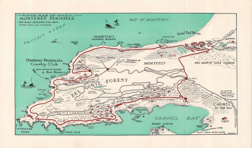
Philip L. Nesbitt (1905 - 1953) was an artist and illustrator who lived in Pacific Grove, California and mostly produced works related to the Monterey Peninsula. Early in his career, he worked as an illustrator for Disney. More by this mapmaker...

Condition


Very good. Original fold lines visible, with minor wear.