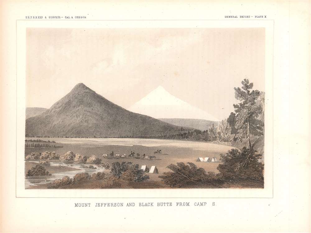
This is an 1857 view of Mt. Jefferson, a stratovolcano and the second highest peak in Oregon, and Black Butte, a smaller extinct stratovolcano twenty-one miles to the southeast of Mt. Jefferson. The two peaks are part of the Cascade Range and sit within the Willamette and Deschutes National Forests. The view was produced for the Pacific Railroad Surveys, an important precursor to the Transcontinental Railroad and also a great storehouse of research material about the environment and peoples of the American West just after these areas were incorporated into or conquered by the United States.
A Closer Look
This view looks towards the northwest. The waterway to the left in the foreground may be the Indian Ford Creek or the Whychus Creek. The mountain peaks played an important role in the oral traditions of nearby indigenous groups, who were later consolidated on the Warm Springs Reservation to the north of the spot where this view was drawn. Lieutenant H. L. Abbot was the engineer tasked with surveying this area for the Pacific Railroad Surveys. He concluded that a railroad through the Cascades would not be feasible, and indeed rail construction in the following decades was concentrated in the more amenable lowlands of the Willamette Valley to the west.The Pacific Railroad Surveys
Following the annexation of Texas and Upper California at the end of the Mexican-American War, the United States found itself controlling a coast-to-coast empire. The 1849 California Gold Rush led to rapid westward expansion and a population bubble on the west coast. Connecting California to the Eastern Seaboard with an overland railroad route was essential to the growth and stability of the country.
Hopes for the railroad where high, and Congress authorized a series of preparatory surveys of practical routes, known collectively as the Pacific Railroad Surveys, to be completed between 1853 and 1855. The resulting reports, including maps, plates, charts, and graphs, provided an incredible body of data about the ecology and cultures of the western regions of North America soon after their incorporation into the United States. The present view, along with others accompanying the surveys, highlight the fundamental duality of the West, a harsh and hostile environment that is simultaneously indescribably beautiful.
While all agreed on the importance of Pacific Railroad, not everyone in power was ready to act. Lobby groups published propaganda to illustrate the benefits of the route, and ultimately, in 1862, Congress passed the Pacific Railway Act, leading to the chartering of the Union Pacific Railroad Company, charged with constructing the route. But by this time the United States was fully embroiled in the American Civil War (1861 - 1865), which further stymied construction. It was not until May 10, 1869, that the robber baron and railroad tycoon Leland Stanford drove the Golden Spike at Promontory Summit, Utah Territory, linking the eastern and western spurs of the Pacific Railroad, creating the first transcontinental railroad.Publication History and Census
This view was included as Plate X in Volume VI of the Reports of explorations and surveys : to ascertain the most practicable and economical route for a railroad from the Mississippi River to the Pacific Ocean. While the Reports are well represented in the OCLC, this view is only known to be cataloged independently by the Smithsonian National Museum of American History's Bering Center and the Osher Map Library at the University of Southern Maine. It is very scarce to the market. The example held by the Smithsonian is dated to 1857 and is attributed to A.O.P. Nicholson, based on an original drawing by John Young, while the example held by the Osher Map Library is dated to 1855 without attribution.
Cartographer
The Pacific Railroad Surveys (1853 - 1855) were established in 1853 with the goal of identifying the best possible routes for a transcontinental railroad from the Mississippi to the Pacific. The need for transcontinental railroad made itself evident shortly after the California Gold rush when the westward expansion was at its heights. The federal government, acting under the Sectary of War, Jefferson Davis (of Civil War fame), initiated a series of expeditions of the western territories. These expeditions included surveyors, cartographers, artists, zoologists, botanists and geographers. The resultant work, a 12 volume compendium entitled Reports of Explorations and Surveys, to ascertain the most practicable and economical route for a railroad from the Mississippi River to the Pacific Ocean eventually led to the constructions of several different transcontinental railroads. More by this mapmaker...
Source
Reports of explorations and surveys to ascertain the most practicable and economical route for a railroad from the Mississippi River to the Pacific Ocean, Volume VI: Routes in Oregon and California.
Very good.
Smithsonian Museum of American History, Catalog Number 10729.12. Osher Map Library Smith Collection, Barcode 13952.