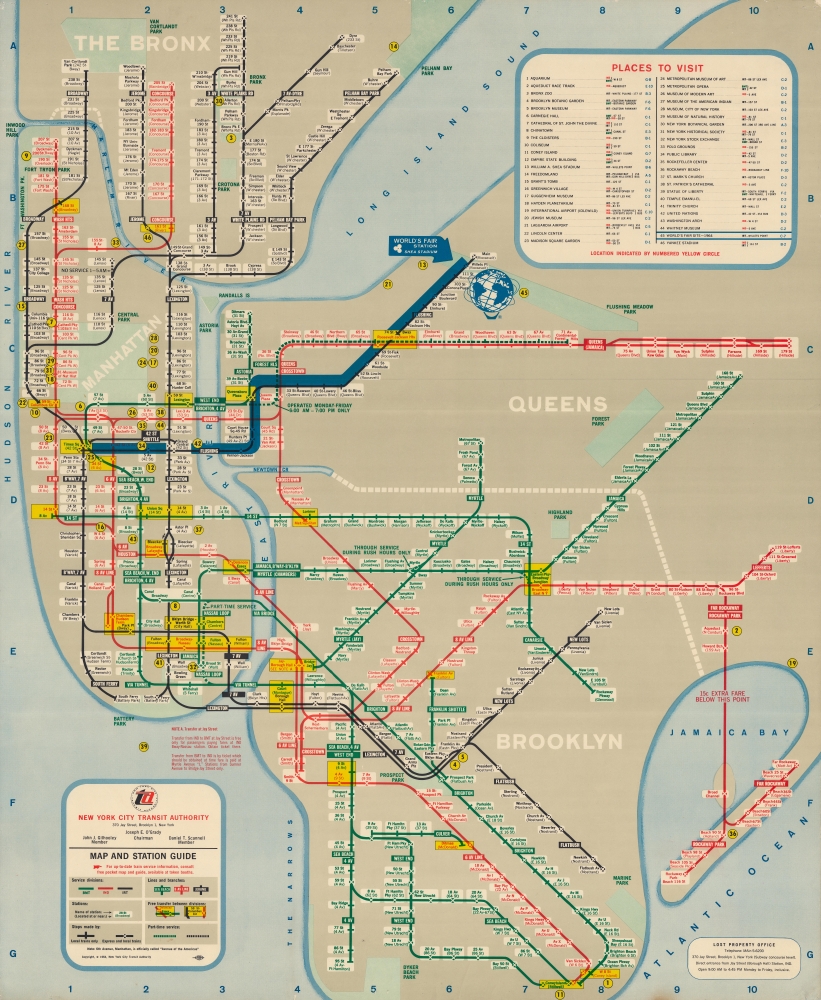
This is a 1964 New York City Transit Authority in-station subway map by George Salomon highlighting the 1964 New York World's Fair. Large-scale subway maps like this were made for in-station display only and were neither sold nor otherwise distributed to the public. Moreover, as the subway evolved, they quickly fell out of date, and most examples thus destroyed, making them exceptionally rare discoveries. Focusing on the World's Fair, this map would have remained relevant only for months.
A Closer Look
This large map details subway lines in four of the five boroughs (Manhattan, The Bronx, Brooklyn, and Queens), color-coded according to divisions (former BMT, IND, and IRT). Specific lines are identified by name, stops are labeled, and the nearest cross street is provided. Yellow boxes highlight stations where free transfers are possible between divisions. Forty-six locations are numerically identified and correspond with an index in the upper right, not far from the World's Fair site.Out of the Labryinth
Drawing inspiration from Harry Beck's geometric map of the London Underground, George Salomon submitted a visionary proposal to the New York City Transit Authority (NYCTA) in 1957, aptly titled Out of the Labyrinth. This report introduced a novel methodology for depicting the New York Subway system, a task that had previously challenged many to represent its intricate network clearly for passengers on the go. Salomon's' inaugural map was released in 1958, featuring marked simplifications and distortions of the subway lines and the city's geography. His innovative design would later influence future Subway map creators, including the renowned Massimo Vignelli.The 1964 - 1965 New York World's Fair
The 1964 - 1965 New York World's Fair was held in Flushing Meadows-Corona Park, previously the site of the 1939-1940 New York World's Fair. The fair took place over two six-month seasons during the summer and early fall of 1964 and 1965. The Unisphere was the central attraction and remains an architectural oddity. New York businessmen organized the fair, hoping to mirror the success of the 1939-1940 World's Fair. Ultimately, over 51 million people attended the fair, which was undoubtedly a good turnout despite falling short of the hoped-for 70 million.Publication History
George Salomon originally designed this map for the New York Transit Authority in 1858. The present example, with the World's Fair updated, appeared in 1964. It was issued in the wall size (as here) and in a pocket size, which we have handled before (nysubwayworldsfair-nycta-1964). We note examples of the pocket map appearing on the market occasionally, but this significantly larger in-station edition is unique and has no collection records or market history.
Cartographer
George Salomon (1920 - 1981) was a graphic designer based in New York who advocated for and helped design a comprehensive and easy-to-use map of the New York City subway system. Born to a Jewish family in Hamburg, Germany, Salomon emigrated with his family to the United States in 1938 after he completed high school. He attended Swarthmore College and established a fund to help fellow refugees from Nazi Germany. After graduating, he moved to New York City to pursue his career in the printing industry and graphic design. More by this mapmaker...
Good. Pinholing along top and bottom edges. Slight loss to both bottom corners. Closed edge tears professionally repaired on verso.