Title
America - A Nation of One People From Many Countries.
1940 (dated)
33.75 x 52.5 in (85.725 x 133.35 cm)
1 : 4000000
Description
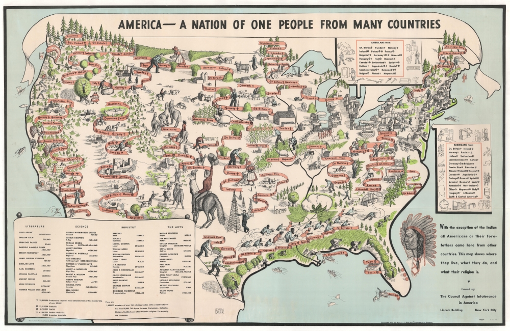
One of the greatest and most poignant pictorial maps of all time, this 1940 Emma Bourne pictorial map of the United States is a call for unity and mutual acceptance in an era defined by racism, xenophobia, nativism, nationalism, and isolationism. When the Council Against Intolerance in America released this map, World War II (1939 - 1945) was already raging in Europe and Asia, fueled by extremist ideologies. Within a year, the United States, too, would find itself embroiled in the global conflict.
A Closer Look
Coverage embraces the United States, with red-orange banners illustrating where various immigrant communities settled, with symbols marking religious affiliation (as long as it's Christian or Jewish). Faceless figures throughout are hard at work mining, farming, ranching, and manufacturing, underscoring the dynamic immigrant spirit. A table in the lower left lists famous authors, artists, scientists, and industrialists, noting their ancestry. These include John Steinbeck, Ernest Hemingway, Thomas Jefferson, Albert Einstein (who became an American citizen in 1940), J.P. Morgan, and Cornelius Vanderbilt, among others. A short text on the bottom right states, 'With the exception of the Indian all Americans or their forefathers came here from other countries. This map shows where they live, what they do, and what their religion is.'Not a Perfect Piece
While the call for tolerance and acceptance is admirable, this piece cannot avoid racial and ethnic stereotypes. The term 'Negroes' broadly defines the African American community. Bourne was doubtless not up to the task of addressing the cultural diversity of black Americans or the legacy of slavery. Nonetheless, Marian Anderson and George Washington Carver appear among the lauded luminaries in the lower left. China and Japan are referenced along the Pacific. Native Americans, while named textually at right, accompanied by a large profile portrait (in fact, the only frontal face on the map), are not otherwise evident. Langstons Hughs Criticizsms
The Beinecke Library at Yale holds an example of this map hand-annotated by the African American poet and social activistLangston Hughes (1901 - 1967). His poignant annotations include a burning cross labeled 'K.K.K.' in the southeast and a note reading 'tote that cotton - roll that bale!' near a textile mill. Hughes also underlined 'Negroes' in the key and wrote 'Africa' next to it.The Council Against Intolerance in America
The Council Against Intolerance in America (1938 - c. 1954) was founded in December 1938 by James Waterman Wise (the son of Rabbi Stephen S. Wise, the head of the American Jewish Congress). Wise's mission (alongside spreading the ideas of both racial and religious tolerance) was to combat the Nazi-oriented German-American Bund. The Council published booklets and other pro-American literature, promoting the idea that intolerance was un-American and would harm the country. The Council created two exhibits, entitled 'The Negro in American Life' (1944) and 'The Jew in American Life' (1946). 'The Negro in America' began circulating in May 1944, and by 1945, there were 450 showings in 185 cities. The Council also published the film Forward - All Together and a photographic news service called Pictures for Democracy.Publication History and Census
This map was created by Emma Bourne and published in 1940 by the Council Against Intolerance in America. There are a few minor variations. Some have folds, others do not. Some have the Davidson Printing imprint in the lower left, as here, others do not. We note 11 examples in OCLC plus another 3 or 4 in other institutional collections. Examples of this map appear on the market from time to time.
Cartographer
Emma Cartwright Bourne (February 23, 1906 - April 19, 1986) was an American etcher and painter. Born in Norwalk, Connecticut, Bourne attended Vassar College (1927). She married Robert Donaldson Darrell, a writer, on September 30, 1930, and may have divorced at some point. She lived in Connecticut, New York, and Massachusetts for her entire life. Very little of her work has been cataloged. A piece called 'Head of a Man' is part of the collection at Smith College and a collection of her sketches appeared at auction in 2020. More by this mapmaker...
Condition
Very good. Trimmed to neat line and mounted on linen. Color slightly faded.
References
Hornsby, S., Picturing America: The Golden Age of Pictorial Map, Plate 19. OCLC 51509501.