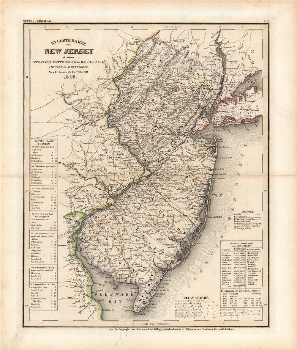
This is an 1846 Joseph Meyer map of New Jersey. A transportation map at its finest, Meyer focuses on the state's roads, railways, and canals. Three railroads traverse the state, but only the Camden and Amboy Railway is identified by name. The Camden and Amboy was the first railroad in operation in New Jersey and began running between Bordentown and Hightstown in 1831, only fifteen years before this map was published! Numerous cities, towns, and villages are labeled throughout, and distances between them are marked in miles. To complete the aesthetic of a transportation map, routes between Trenton and six regional cities (New York appears twice) provide an idea of how best to get from one place to the other and how long it will take.
Publication History
This map was created by Joseph Meyer and published in the 1850 edition of his Meyer's Zeitung Atlas. Curiously, the publication information provided below the bottom border lists Heidelberg, Amsterdam, Paris, and Philadelphia as cities of publication, suggesting that Meyer had publishing agreements with atlas publishers in France, Holland, and the United States. Meyer published two editions of his atlas: the first in 1845 and a second in 1850.
Cartographer
Joseph Meyer (May 9, 1796 - June 27, 1856) was a German industrialist and publisher, most notably for the encyclopedia Meyers Conversation-Lexicon. Born in Gotha, Germany, Meyer was educated as a merchant in Frankfurt am Main. He moved to London in 1816, but returned to Germany in a820 after his stock speculations and business adventures fell through. Once back in Germany, he began by investing in the textile trade (1820-24). Meyer began creating business plans concerning how to start railways soon after the first steam-hauled railway began operation in December 1835. He founded the Deutsche Eisenbahnschienen-Compangie auf Actien (German Railway Rail joint stock company) in 1845. Meyer also found great success as a publisher, utilizing the system of serial subscriptions to publications, a new idea for the time. He founded a company, Bibliographisches Institut in Gotha in 1825, which published several versions of the Bible, works of classical literature, atlases, the world in pictures on steel engravings, and an encyclopedia. More by this mapmaker...
Source
Meyer, J., Meyer's Zeitung Atlas (Heidelberg: Bibliographischen Instituts), 1845.
Meyer's Zeitung Atlas, formally titled Neuster Zeitungs-Atlas Fuer Alte und Neue Erdkunde was a popular German hand-atlas published in Heidelberg by Joseph Meyer between, roughly, 1848 and 1859. The atlas is well engraved in the German style with exceptionally dense detail and minimal decoration. Meyer's Atlas, and its constituent maps, are typically very difficult to date as later editions often contain earlier maps and earlier editions later paste-in updates. That said, the atlas' frequent updates and publication run during a turbulent decade provide a noteworthy cartographic record of the period.
Very good. Exhibits light toning. Original outline color.
Rumsey 4807.144. OCLC 49245481.