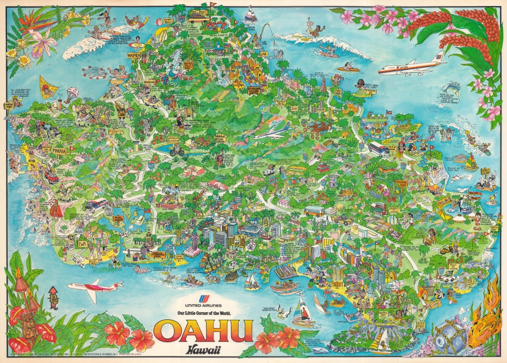
This is a 1978 Kim Forrest pictorial map of Oahu in the Hawaiian Islands. The map promotes tourism to Hawaii via United Airlines, including nonstop flights to Hawaii and Oahu on the cutting-edge Boeing 747, marking a major step in connecting Hawaii physically and culturally to the U.S. mainland.
A Tourist's Paradise
Emphasizing the ease of access to Hawaii in the jet age, three jet airliners appear here, including a United 747 at top right and two smaller jets flown by Hawaiian Airlines and Pacific Western Airlines, respectively. Oahu's cities and towns are labeled, including Honolulu, Wahiawa, Laie, Haleiwa, and Waimea. Tourist attractions, such as the Polynesian Cultural Center in Laie (next to Brigham Young University and the Mormon Temple) and Sea Life Park are emphasized, while hidden gems like the Wahiawa Botanic Gardens are also labeled but less well known. The Bishop Museum which focuses on Hawaiian history appears as well. Tourists appear posing for pictures and lounging on the sand on Waikiki Beach with grand hotels just behind them. The Honolulu Zoo also takes pride of place and is marked by a smiling kangaroo, elephant, giraffe, and other animals. All around the island tourists are illustrated swimming, snorkeling, surfing, and generally enjoying Oahu's incredible climate.A Little History Too
Hawaii's importance to the U.S. military is evident but understated, with air force and army bases labeled and a note states that over 800 ships are serviced in the Pearl Harbor Navy Yard annually on average. The U.S.S. Arizona Memorial and the U.S.S. Utah are both illustrated in Pearl Harbor and the National Memorial Cemetery of the Pacific in the Punch Bowl appears as well, underlining Oahu's importance during World War II. Amelia Earhart makes an appearance, commemorating her achievement of accomplishing the first solo flight from Hawaii to North America. Not to be forgotten, Hawaiian history is included, with the Hawaiian birth stones, Queen Liliuokalani's gardens, and the Iolani Palace all labeled.Publication History and Census
This map was created by Kim Forrest and published by Archar (Western) Inc. in 1978 on behalf of United Airlines. We have been unable to locate any cataloged examples in institutional collections and this map has appeared on the private market only a handful of times in recent years.
CartographerS
Kim Forrest (fl. 1974 - Present) is a Canadian artist. Forrest worked for Hanna Barbara and then for Archer Western, becoming head artist in the Minneapolis office in 1976. Today she works in New Mexico. More by this mapmaker...
Archar / Travel Graphics (1973 - Present) is a Canadian and U.S. publishing company initially based in Toronto, Ontario. The firm is best known for its 'City Character Prints' - cartoonish view style maps intended to express the 'character' of a city. The firm employed a host of in house art directors, as well as a host of freelance illustrators. We find no trace of the company after 1983. Variants of the imprint include 'Archer Western' based in British Columbia and the St. Paul, Minnesota based 'Archar International'. Around 1984, the Minnesota firm was renamed Travel Graphics - Archer International, often printing under the 'Travel Graphics' imprint. Travel Graphics later relocated to Hawaii, where they remain active. Learn More...
Very good. Closed margin tears professionally repaired on verso. Minor chipping to top edge.