1939 Le Petit Parisien Map of the World during World War II

OperationsGuerreMondiale-petitparisien-1939
$650.00
Grande Carte en Couleurs du Théatre des Opérations de la Guerre Mondiale. - Main View
Processing...

1939 Le Petit Parisien Map of the World during World War II

OperationsGuerreMondiale-petitparisien-1939

The world at the outbreak of WWII.
$650.00

Title


Grande Carte en Couleurs du Théatre des Opérations de la Guerre Mondiale.
  1939 (undated)     26 x 37 in (66.04 x 93.98 cm)     1 : 29000000

Description


This is a 1939 Le Petit Parisien world map illustrating World War II before the Spring 1940 offensive. The map depicts the world from the Atlantic Ocean to Alaska and Hawaii and from the Arctic to the Cape of Good Hope, Australia, and New Zealand.
Geography of War-torn Europe
Printed before the 1940 German offensive in Western Europe, this map predates the defeat of France. The map reflects the German and Soviet gains of 1939, when Nazi Germany and the Soviet Union signed the Molotov-Ribbentrop Pact and divided Poland between themselves. The borders of Nazi Germany also reflect the Anschluss, the annexation of Austria in March 1938, and the occupation of Czechoslovakia, which took place in two phases. First, under the terms of the Munich Agreement, Nazi Germany occupied the Sudetenland (the northern and western border regions of Czechoslovakia), supposedly as a means of protecting ethnic Germans who lived there. Then in March 1939, the German army invaded the rest of Czechoslovakia and proclaimed it a Protectorate of the German Reich.
War in Asia
Meanwhile, in Asia, war had been raging on and off since 1931, with the Second Sino-Japanese War 'officially' beginning in 1937. The Japanese puppet state of Mancukuo (Mandchoukouo), established in 1931 following the Mukden Incident, is the only immediately obvious clue to the fighting in Asia. The Japanese Mandates in the Mariana, Caroline, and Marshall Islands are labeled, but there is as yet no hint of the critical role they will play in the Pacific War.
The Colonies Still Matter!
It is also important to note the unremarkable, though important, presence of colonial labels throughout the map. For example, Vietnam, Laos, and Cambodia are referred to simply as Indochine (Indochina), then a French colony, while India is the Indian Empire, the jewel of the British Empire. The political geography of Africa looks nothing like it does today, with French North Africa, French West Africa, French Equatorial Africa, Belgian Congo, and Italian East Africa among the many political entities that have since vanished. Even the United States is included, with colonies in the Philippines, Guam, Wake Island, and Hawaii (which were still a territory in 1939).
A Snapshot of History
Overall, this map provides a snapshot of the world as it stood in the fall of 1939 and the first few months of 1940. A world in chaos, marred by brutal warfare on three continents, with an uncertain future.
Publication History
Although undated, through the geography we are able to date this map to late 1939 or early 1940. It was printed by the French newspaper Le Petit Parisien. We have been unable to locate any other surviving examples.

Cartographer


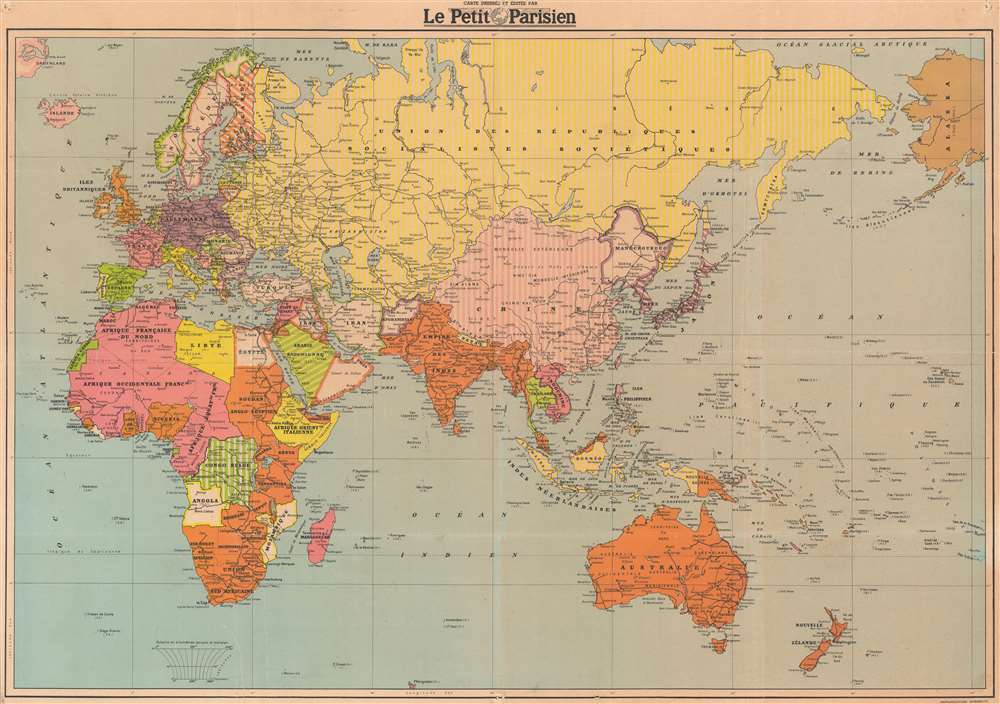
Le Petit Parisien (October 15, 1876 - August 17, 1944) was one of the main newspapers of the French Third Republic. On the eve of World War I, it was one of the four largest daily newspapers in France, along with Le Petit Journal, Le Matin, and Le Journal. Founded in 1876 by Louis Andrieux, it began as a radical leftist newspaper. In 1884 Jean Dupuy bought Le Petit Parisien, which would stay in the Dupuy family until it was suspended after World War II. At its most successful, just after the end of World War I, the paper had a distribution of 2 million copies, the largest circulation in the world at that time. Jean Dupuy died on December 31, 1919, and direction of the newspaper fell to his two sons, Pierre and Paul. On the eve of World War II, its circulation had begun to falter, but the newspaper was still in print and reported the news. The edition of June 11, 1940 of Le Petit Parisian would be the last ‘true’ edition of the paper to be printed in Paris. Following the Armistice, the paper remained in print, but began to feel the pressure of the Occupation and the Vichy regime. Eventually, Pierre Dupuy was convinced by German and French authorities to return to Paris and to continue printing Le Petit Parisien, but by February 1941, the newspaper had been completely coopted by the Germans and became a mouthpiece for the Occupation. A former worker at the time stated that the paper ceased to be le Petit Parisien, but became le Petit Berlinois. Dupuy, disgraced, left the newspaper, and went to Vichy. The Germans continued to print the newspaper, and continued to pressure Dupuy to sell them the paper. After the liberation of France, Dupuy and others who worked for the newspaper were arrested and charged with collaboration offenses. HIs trial did not begin until 1949, and he was finally acquitted in July 1951. The newspaper Parisien libéré replaced Le Petit Parisien after the war. Today’s newspaper, Le Parisien has its roots, particularly its naming rights, in the Petit Parisien, which were sold several times before being bought by Émilien Amaury, who founded Parisien libéré and, eventually, Le Parisien. More by this mapmaker...

Condition


Very good. Backed on archival tissue for stability. Blank on verso.