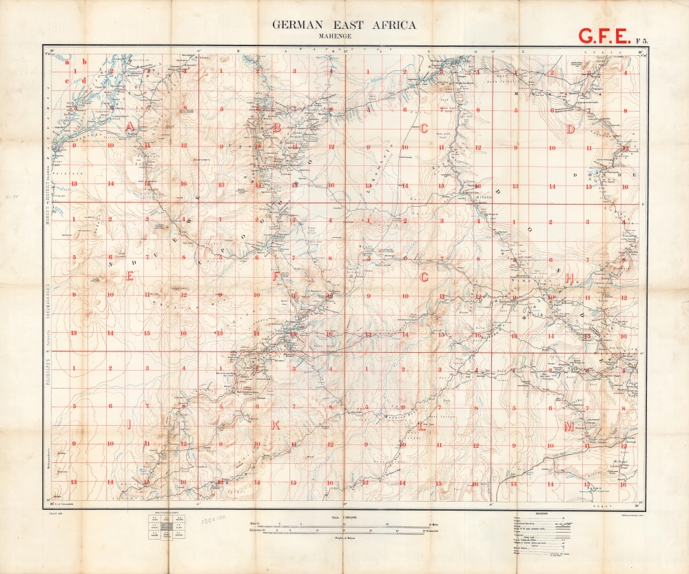
A large format 1916 map of Mahenge and environs in German East Africa, produced by the British Ordnance Survey. Shortly afterwards, this region became the objective of the Mahenge Offensive, a successful Allied operation won primarily by Belgian Congolese forces that resulted in the occupation of the namesake town.
A Closer Look
Focusing on southern-central German East Africa (now Tanzania), with the town of Mahenge appearing near top-center, this map takes in rural, hilly, and largely forested terrain, much of which is now part of the Nyerere National Park. Towns and villages, roads of various types and quality, mission stations, and other features are indicated throughout, including 'mbuga,' low terrain that becomes swampy in rainy seasons (the more-or-less standard Ordnance Survey legend of the time also includes features that are not present on the map, such as railways). Extensive notes pertaining to water sources and terrain appear, key information for military planners.
A grid overlays the map, subdividing latitude and longitude lines into discrete parcels that could be used for precise reference. Notes in the margins refer to neighboring areas; at left, 'Wanga's District,' 'Fliguafu's, formerly Sakamaganga's,' and 'Mohamakiro's' presumably denote indigenous leaders. As seen in the bottom margin, this sheet was part of a series produced by the Ordnance Survey covering German East Africa; though not stated explicitly, it is highly likely that German maps produced in the years preceding the war were consulted extensively to prepare the present map.The East Africa Campaign
The opening phase of the First World War in East Africa was highly disappointing and even embarrassing for Allied forces. Unlike the trench warfare of the Western Front, the conflict in Africa was defined by mobile frontier campaigns, fought largely by colonial troops and African conscripts called askari. The greatly outnumbered German forces under Paul Emil von Lettow-Vorbeck (1870 - 1964) repeatedly defeated or otherwise tied down their foes with guerilla tactics, inspired by Lettow-Vorbeck's earlier battles against insurgents in German Southwest Africa.
Nevertheless, after bringing in reinforcements and drafting a massive labor force of porters, the British and Belgians launched a largely successful offensive in the spring of 1916 that resulted in the capture of most of the northern portion of German East Africa. By September 1916, Allied troops controlled the railways and German troops had been pushed to the south. This map would have been used to help plan the following offensive, known as the Mahenge Offensive (August - October 1917), largely fought to the northeast in the Morogoro Region. Again, Belgian troops and porters proved critical, and by October 3 the Allies had captured Mahenge. Satisfied with these gains, most of the Allied troops withdrew to secure captured railways to the north, while German forces would hold out in the south until the end of the war, continuing their effective use of guerrilla tactics and even launching offensives into Portuguese Mozambique and British Rhodesia.
The East Africa campaign is significant not only for the changes it brought to the region's geography and political arrangements, but because of the postwar activities of its major antagonists. Lettow-Vorbeck returned to Germany as a hero and helped to put down the Spartacist uprising in 1919. After being implicated in the failed Kapp Putsch of 1920, Lettow-Vorbeck left the army and later entered politics; he was oriented on the far right but had a difficult and testy relationship with the Nazis. The main Allied commander, Jan Smuts (1870 - 1950), became the Prime Minister of South Africa and played an important role in the creation of the League of Nations and later the United Nations.Publication History and Census
This map was produced in 1916 by the British Ordnance Survey and was one of a series produced by them for the Geographical Section of the General Staff (abbreviated and coded at bottom-left). It is noted among the holdings of the University of Cape Town, the British National Archives, the United Nations Archives in Geneva, and the National Library of Australia and is very scarce to the market.
Cartographer
The British Ordnance Survey (1791 - present) is the national mapping agency of Great Britain and is one of the largest producers of maps in the world. This non-ministerial department of the government of the United Kingdom is responsible for producing maps of Great Britain and many of its overseas possessions. The history of the Ordnance Survey goes back as far as 1747, following the Jacobite rising, when King George II commissioned a comprehensive military survey of Scotland to assist further campaigns. The result, produced by Paul Sandby, John Mason and William Roy, was the Duke of Cumberland's Map, the first military quality map of the British Isles. This grew into the Principal Triangulation of Great Britain (1783-1853) under William Roy, and eventually lead to the creation of the Ordnance Survey in 1791. Today the Ordnance Survey produces a large variety of paper maps and digital mapping products. Its large scale maps, issued to the scale of 1:10000, available in sheet map form until the 1980s, are now only available digitally. All maps produced by the Ordnance Survey are in copyright for 50 years after publication. More by this mapmaker...
Good. Toning and wear along fold lines, with some loss at intersections. Mounted on linen.
OCLC 903416378.