1950 Sheets Pictorial Historical Map of Northern California

PageantHistoryNorCal-sheets-1950
$250.00
The Pageant of History in Northern California its colorful and adventurous beginnings. - Main View
Processing...

1950 Sheets Pictorial Historical Map of Northern California

PageantHistoryNorCal-sheets-1950

God, gold, and guns.
$250.00

Title


The Pageant of History in Northern California its colorful and adventurous beginnings.
  1950 (undated)     15 x 21.5 in (38.1 x 54.61 cm)     1 : 725000

Description


A richly illustrated c. 1950 pictorial map of Northern California, drawn by Millard Sheets and commissioned by the American Trust Company. It provides an overview of the early history of the region, from its indigenous inhabitants through the gold rush and beyond.
A Closer Look
Replete with historical allusions, the map covers the area from Sonoma County at north to the Monterey Peninsula at south and inland to the Sierra Nevada. At top is Fort Ross, a Russian trading post in today's Sonoma County, and the Sonoma Barracks, site of the 1846 Bear Flag Revolt. Less than a month after the revolt, U.S. marines captured Monterey, depicted near bottom, as part of the Mexican-American War. Further inland are scenes depicting dancing Native Americans, Spanish friars and conquistadores, vaqueros wrangling cattle, the gold rush, the arrival of railroads, battles between settlers and Native Americans, a stagecoach robbery, the dispensation of frontier justice, and bucolic depictions of trees and animals.
Publication History and Census
This map was drawn by Millard Sheets around the year 1950 and printed by lithogravure. It was paired with a map done in a similar style titled 'The Panorama of Today in Northern California.' Due to uncertainty over the publication date of this work, it is cataloged twice in the OCLC. By either reckoning, the map is held by Stanford University, the University of California Berkeley, the University of California Los Angeles, the University of Illinois at Urbana Champaign, and the Huntington Library.

Cartographer


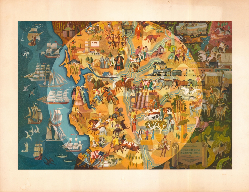
Millard Owen Sheets (June 24, 1907 - March 31, 1989) was an American artist and designer best known for his watercolors and murals. Born in Southern California, he attended the Chouinard Art Institute and was a student of Frank Tolles Chamberlin and Clarence Hinkle. Even before graduating, he was highly regarded for his watercolors and his work was soon displayed all over the country. During the Great Depression, he was a leading figure in the Public Works of Art Project, and during the Second World War, he spent time in South Asia as an artist-correspondent. During the 1930s-1940s, he increasingly took up large-scale mural projects, including mosaic murals. He also worked in bronze sculpture and stained glass, and also produced architectural designs. His works are strongly influenced by Realism, taking working and oppressed peoples as their subject, and bear some resemblance to other celebrated artists of the era, such as Diego Rivera. Sheets is considered one of the founders of California Scene Painting. More by this mapmaker...

Condition


Very good. Some uneven toning and other minor imperfections in the margins.

References


Rumsey 8081.000. OCLC 953572734, 24181008.