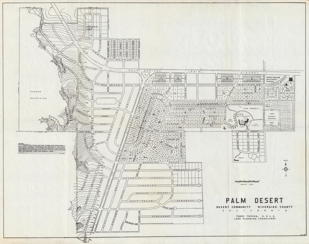
The original 1946 planning map of Palm Desert, California, by city founder Tommy Tomson. Palm Desert is one of California's most successful post-war planned communities - here laid out and planned when it existed only as a dream.
A Closer Look
This urban planning map presents Palm Desert, near the intersection of two highways, the Palm Springs-Indio Highway (CA-111) and the Palms to Pines Highway (CA-74, now officially designed as a Scenic Byway). Although Palm Desert materialized, its ultimate construction did not perfectly match this plan. For example, the layout and names of roads at bottom, south of Grapevine St., and at top, north of the Palm Springs-Indio Highway, differ significantly (a note at left indicates that changes were expected). Palm Desert's boundaries were also later extended far to the north (now consisting of multiple country clubs) and somewhat further to the south. But the town as constructed did largely reflect the contours seen here, including the distinctive shopping corridor of 'El Paseo' running parallel to CA-111 and the core of the community being the club seen here, soon afterward named the 'Shadow Mountain Club' (membership in the club came with the purchase of a plot of land).
Aside from the club, which added a golf course to the tennis courts seen here, most of the planned town consists of plots for housing in addition to a church, school, park, and stables, along with unplotted lands, including in the hills and mountains west of the town. El Paseo became a purely commercial corridor rather than mixed residential and commercial, as envisioned. The Palm Desert Corporation limited home sizes and styles to maintain the 'look' of the community, with plots and homes immediately east of the club and near Highway 111 designed to be smaller than those to the immediate west of the club. Tomson named and laid out the streets, with a preference for curvy streets (which he considered more interesting), as well as the landscaping along them. The goal was to combine the 'romance' of life in California's desert with modern conveniences, evidenced, for example, by the close proximity of bridle paths with parking lots.'Wasteland to Wonderland'
This portion of the Coachella Valley was historically inhabited by the Cahuilla people, many of whom became farmers on date farms established in the 1920s. During World War II (1939 - 1945), the future site of Palm Desert was used as a maintenance camp and training ground for U.S. Army tanks. A sustained town emerged in the postwar period when the Henderson brothers and their brother-in-law Tommy Tomson purchased the land from the government and developed it as a planned community, attracting investors among the business and entertainment elite of Los Angeles.
Among California's postwar planned desert communities, Palm Desert is one of the more successful, no doubt aided by its magnificent scenery and warm winters (like other towns in the Coachella Valley, Palm Desert's population varies considerably by season). Though growth was relatively slow at first (just shy of 1,300 residents in 1960), it picked up, reaching over 6,000 residents by 1970, over 23,000 by 1990, and over 50,000 today.Publication History and Census
This map was drawn by land planning consultant Tommy Tomson for the Palm Desert Corporation in December 1946, with the added note at left dated May 1947. We are unaware of any other examples.
Cartographer
Tommy Tomson (1900 - 1986), also known as Charles G. Tomson and Golden Sands Tomson, was a surveyor, landscape architect, and urban planner closely associated with the development and history of Palm Desert, in California's Coachella Valley. Born in Zanesville, Ohio, Tomson trained as a surveyor in Michigan before relocating to the American Southwest, working in Albuquerque, Texas, and Hollywood. After briefly considering a career as an actor, Tomson committed to surveying and urban planning. In Los Angeles, he met and married Dorris Henderson, a California native from the inland desert to the east and south of Los Angeles. After a stint in Portland, Oregon, Tomson returned to Los Angeles, where he was tasked with planning the landscaping for the infield at the Santa Anita Park horse racing track. This project gained him acclaim and many new clients, including celebrities (the likes of Henry Fonda, Frank Sinatra, and Red Skelton) looking for elaborate landscaping for their homes. He was also given additional projects for public institutions, including a patio at Union Station, laying out swimming pools for hotels in Beverley Hills, and designing the landscaping for the Park La Brea housing community. His designs are credited with helping create the postwar image of Southern California defined by swimming pools, palm trees, and an adaptation of California's romanticized, mythologized past to homes designed with outdoor leisure in mind. He became particularly well known for his 'kidney shaped' and figure 8 swimming pool designs, as well as the famous piano-shaped swimming pool in Frank Sinatra's Palm Springs home. After the Second World War, Tomson and his four brothers-in-law undertook a project to develop land in the inland deserts of Southern California. Government-owned land, which had been used by the military during the war, was being sold at a very favorable price on the condition that investments and improvements were made to the land. The land chosen by Tomson and the Hendersons in 1946 was just off Highway 74, not far from Palm Springs, and was dubbed by one of Tomson's brothers-in-law as Palm Desert. Tomson chose a plot and built a house for his family, though they initially only stayed for weekends given the lack of services and infrastructure. Later, Tomson retired to a grand, distinctive Spanish-style 'hacienda' that he designed and built in Palm Desert, complete with a chapel, blacksmith shop, and faux ruins of an aqueduct. More by this mapmaker...
Good. Light wear and toning along original folds. Toning and chips around edge. Area of infill at central fold intersection. Two areas of infill along edges.Several tears professionally repaired.