Title
Thurston's Map of Pasadena So. Pasadena Altadena and San Marino.
1915 (dated)
26.5 x 20 in (67.31 x 50.8 cm)
1 : 20600
Description
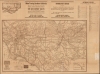
An unrecorded 1915 map of Pasadena and surrounding towns produced by Albert G. Thurston and the Western Map and Publishing Co. It displays Pasadena undergoing a period of rapid growth wherein the city developed its distinctive identity.
A Closer Look
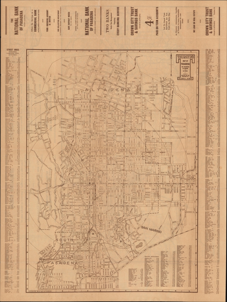
Coverage embraces most of today's Pasadena, Altadena, South Pasadena, and San Marino, this map captures the area's explosive early 20th-century growth. At the time, these towns were growing so rapidly that mapmakers, as here, were compelled to chart future development rather than existing urbanization. This fact becomes clearer when comparing the present map to editions published in subsequent years.
This map predates several of the area's later landmarks, including Pasadena City Hall, the Rose Bowl Stadium, and the Huntington Library. It does include other recognizable features, such as the Mt. Lowe Railway, the only scenic mountain electric traction railroad built in the United States (operational from 1893 until 1938). The importance of regional railways in spurring urbanization is evident here. Lines of the 'Pacific Electric Railway', 'Southern Pacific Railroad, Atchison, Topeka, and Santa Fe Railroad', and the 'San Pedro, Los Angeles, and Salt Lake Railroad' are delineated. Some were elevated on trestles, but others were at-grade street crossings, a consequence of the rushed construction and tight budgets.
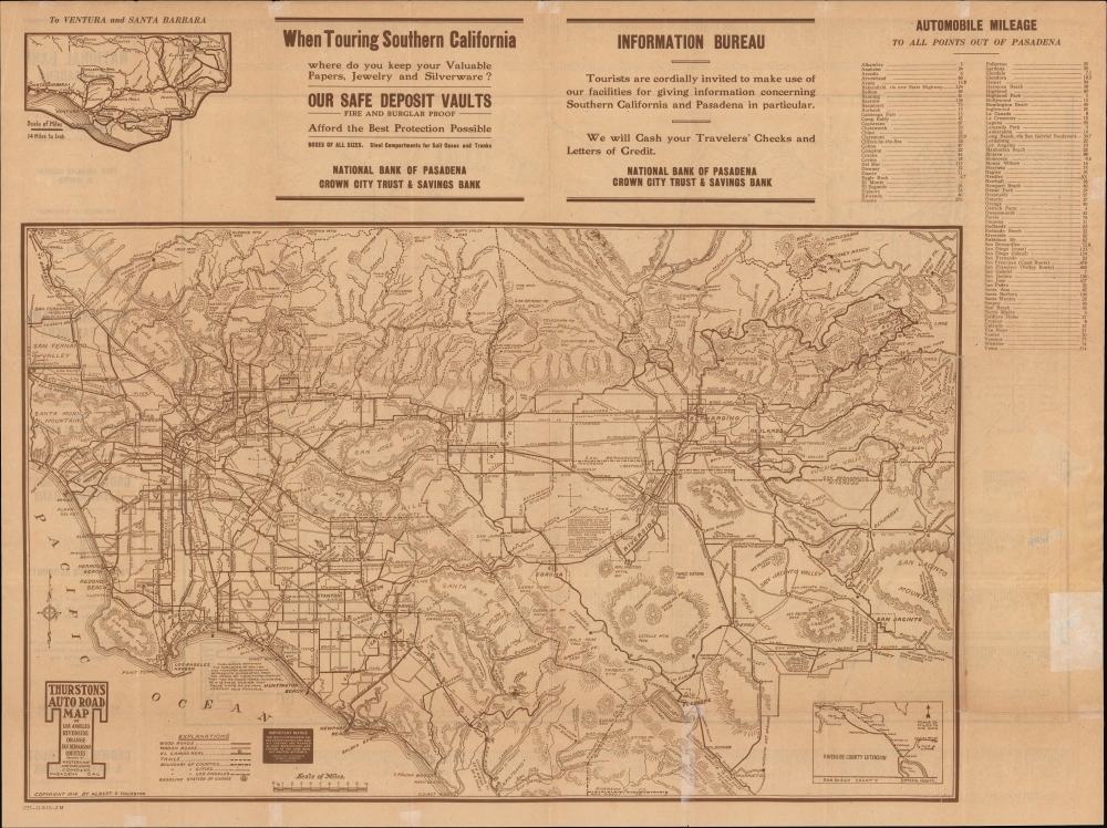
Streets are labeled throughout and listed in an index surrounding the map. Concentric circles at half-mile intervals emanate from the intersection of Colorado Street and Fair Oaks Avenue. Lines mark the city boundary (extended in preceding years), borders between neighborhoods, and projected park sites. A large map on the verso (copyrighted 1914) presents the greater Los Angeles area, with an inset of Riverside County Extension at bottom-right. Major roads and the lines of the Pacific Electric Railway are marked throughout. At top-left is a standalone inset of the roads leading to Ventura and Santa Barbara, while at top-right is a mileage chart of distances between Pasadena and other cities in Southern California and beyond.San Marino, Tournament Park, and the Huntington Estate
Tournament Park, bottom-right in San Marino, is named for the Tournament of Roses held there. The park also hosted the first eight Rose Bowl games, which were later relocated to the Rose Bowl Stadium, which opened in 1922. To the southeast of Tournament Park is the large estate (not labeled) of Henry Huntington, president of the Pacific Electric Railway and a tycoon with interests in various fields, including large real estate holdings in and around Pasadena. Huntington was one of the founders of San Marino, incorporated in 1913, and his lands occupied one of three pre-existing ranchos that combined to form the city. After retiring in 1916, Huntington dedicated his attention to philanthropy and the arts, founding the library and gardens that bear his name.Paradise at the Foot of the San Gabriels
The 'Los Angeles and San Gabriel Valley Railroad' began service in 1885, connecting Pasadena with Los Angeles. Soon afterward, it was acquired by the 'Atchison, Topeka, and Santa Fe Railway' and connected to the latter's expansive network, which opened the growing town to visitors from across the continent. The area's ideal climate soon began to draw tourists. With the support of effective local boosterism, Pasadena became renowned as a Mediterranean-style resort town with opulent hotels and other services. The Mount Lowe Railway and other attractions became destinations in themselves. From less than 5,000 residents in 1890, Pasadena grew to more than 30,000 by 1910.
In the early 20th century, the city center highlighted here, now known as 'Old Pasadena,' took on its distinctive Mediterranean Revival and Spanish Colonial Revival aesthetic, culminating in the 1927 completion of the opulent City Hall complex. Locals developed a strong sense of identity and pride centered on the area's spectacular landscape and climate, summed up in the memorable phrase of Charles Holder, who helped organize the first Tournament of Roses (held on New Year's Day): 'In New York, people are buried in the snow. Here our flowers are blooming and our oranges are about to bear. Let's hold a festival to tell the world about our paradise.'Publication History and Census
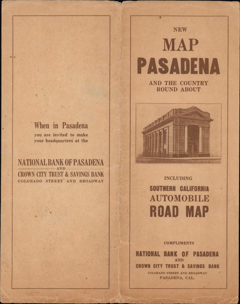
This map was produced and printed by Albert G. Thurston in 1915, with sponsorship from the National Bank of Pasadena (which also owned the Crown City Trust and Savings Bank). Thurston produced maps of Pasadena, where his firm (the Western Map and Publishing Co.) was later based, and nearby cities from 1915 until 1930. The present edition of the map is not independently cataloged among the holdings of any institution and has no known history on the market. As mentioned above, it differs in some respects from the 1916 edition which followed and more so from the 1919 edition. (Collectively held by three institutions - the University of California Berkeley, the California Historical Society, and the University of California Santa Barbara - OCLC 951433392; a 1916 edition is also held by Princeton University, cataloged as OCLC 986267463). A similar map may have appeared in Thurston's Pasadena guide to all streets and intersections, buildings, churches, fire alarm boxes, hospitals… (OCLC 9164438, held by the Wisconsin Historical Society), but the present map is separately-issued.
Cartographer
Albert G. Thurston (c. 1880 - 1930) was a publisher of maps and directories based in Los Angeles and Pasadena, California. The details of Thurston's life are uncertain, partly because several Albert Thurstons lived in the Los Angeles area at the same time. His name appeared in Pasadena city directories (some of which he published) between 1903 and 1929. Thurston published maps and other works under his name, but usually also in conjunction with the Western Map and Publishing Co., which he likely headed. Early in his career, he joined Charles Morris and other partners to form the Morris-Thurston Company, a stationary printer. Thurston looks to have lived and been based in Pasadena but also occasionally appears in records as residing in Los Angeles, where the Western Map and Publishing Co. was based until about 1915. In addition to Los Angeles and Pasadena, Thurston also published maps and directories related to the 'inland empire,' especially Riverside County, and, once it was created in 1907, Imperial County. More by this mapmaker...
Condition
Very good. Light wear along original folds. Several tears professionally repaired. Accompanied by original covers.
References
OCLC 951433392, 986267463 (later editions).