This item has been sold, but you can get on the Waitlist to be notified if another example becomes available, or purchase a digital scan.

1780 Gongora y Lujan de Almodovar Map of the Philippines

Philippines-gongora-1790
$1,600.00
Mapa de Las islas Filipinas. - Main View
Processing...

1780 Gongora y Lujan de Almodovar Map of the Philippines

Philippines-gongora-1790

The Duque de Almodovar's Map of the Philippines.

Title


Mapa de Las islas Filipinas.
  1790 (undated)     15.75 x 12.25 in (40.005 x 31.115 cm)     1 : 3625000

Description


This is an extremely scarce 1790 map of the Philippines prepared for Pedro Jiménez de Góngora y Luján, Duque Almodóvar del Río. The map embraces most of the Philippines from northern Luzon to just south of Mindanao, and west to Palawan.
Sources
Most scholarship suggests this map is derived from Pedro Murillo Velarde's 1734 Carta Hydrographica y Chorographica de las Islas Filipinas, but we do not find this to be a supportable position. The present map offers both greater and lesser detail than the Velarde, with significant corrections in Mindanao, Luzon, Palaway, and among the lesser islands. The present map includes mountains and volcanos not present on the Velarde. Here too, major river systems are enlarged to exaggerate both their course and navigability. Likely he is drawing from latter sources including British and Spanish nautical charts of the late 18th century.
Publication History and Census
This map was made to illustrate Historia política de los Establecimientos Ultramarinos de las Naciones Europeas, published in Madrid between 1784 and 1790. This map appeared in the final volume, published in 1790. No engraver is credited. The separate map is rare both in institutional collections and to the market.

Cartographer


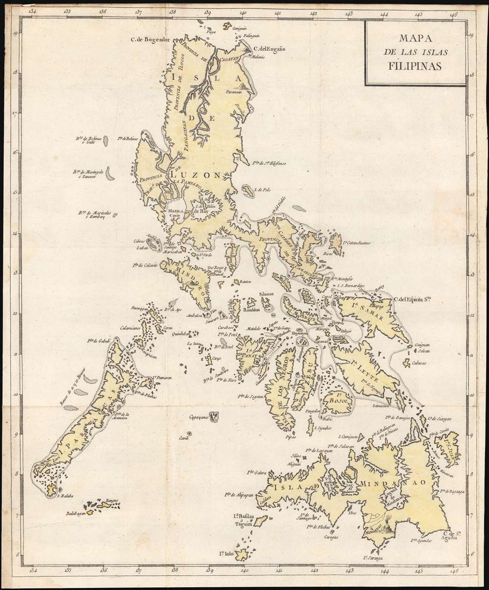
Pedro Francisco de Luján y Góngora (September 18, 1727 - May 14, 1784), 1st Duke of Almodóvar del Río, was a Spanish nobleman, ambassador, and historian. He was made a Grandee of Spain in 1779 and was named 1st Duke of Almodóvar del Río on July 11, 1780. He was the fourth director of the Real Academia de la Historia from January 6, 1792 to May 14, 1794 when he died, although his death has also been quoted as 1796. From 1784, annoyed at the anti-Spanish verbiage of Guillaume Thomas François Raynal's popular Histoire philosophique et politique des établissements et du commerce des Européens dans les deux Indes, Pedro set out to write his own version of the work, Historia política de los Establecimientos Ultramarinos de las Naciones Europeas. An ambitious 12 volumes were planned, but only 5 were published. The early volumes mirrored Raynal's work, but from volume 3, he introduced new ideas and concepts. Nonetheless, after volume 5, José Moñino y Redondo, the Count of Floridablanca (1728 - 1808) prohibited further publication. More by this mapmaker...

Source


Malo de Luque, E., Historia política de los Establecimientos Ultramarinos de las Naciones Europeas, Vol V, (Madrid: Sancha) 1790.    

Condition


Very good. Lower right margin extended.

References


Quirino, C., Philippine Cartography 1320 -1899, page 163.