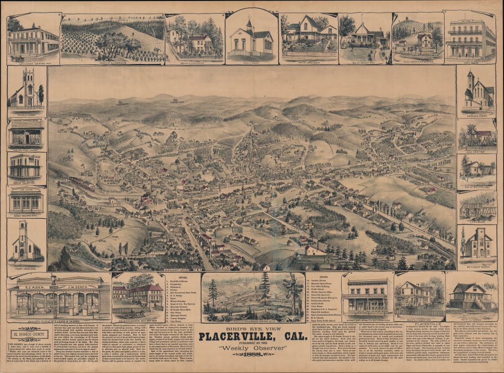
A scarce 1888 Louis Henry Roethe bird's-eye view of Placerville, California, popularly known as 'Hangtown'; for its raucous and violent history during the Gold Rush. Presenting a more urbane image of the town several decades after the Gold Rush, the view nonetheless references Placerville's tumultuous past.
A Closer Look
Oriented towards the north-northeast, this view covers the town of Placerville, with reference to the nearby towns of Georgetown, Greenwood, and Coloma (famous as the site of Sutter's Mill, where gold was first discovered in California), along with the Sierras in the background. Lake Tahoe lies not too far beyond the hills in the right background. This view is unusual and fascinating in that it depicts one of the archetypal Gold Rush towns decades after the Gold Rush, thus representing an early example of local romanticization of the Gold Rush era.
Presenting remarkable detail, down to individual buildings, the view labels streets and waterways throughout, while numbering thirty locations keyed to an index at bottom. These include churches, hotels, railroad infrastructure, schools, a courthouse, an opera house, the post office, a brewery, and more. Several are illustrated in a border surrounding the view, along with depictions of the homes of prominent local residents, local businesses, and the office of the
Weekly Observer, which published the view (some still stand). A small inset view above the title presents the town in 1851 when it was still known as Hangtown (see below). At the bottom, text expounds on the history of El Dorado County while promoting its climate and economic (mostly agricultural) potential.
Rehabilitating Hangtown
Placerville's early history offers one of the clearest examples of the heady, chaotic, and often violent environment of the California Gold Rush. Soon after James W. Marshall discovered gold at nearby Sutter's Mill, thousands of prospectors poured into the region and pitched tent cities, which soon developed into frontier towns. Initially known as 'Dry Diggin's,' the town seen here very quickly came to be known as 'Hangtown' for the frontier justice meted out there. Lacking a police force, mob violence and lynchings were the typical ways of handling murders and other crimes, which usually resulted from barroom brawls and robberies. Historians debate whether Hangtown was more prone to frontier justice than other gold rush boomtowns, and the moniker has long been debated among locals. Some embrace it as a sign of frontier hardiness (the city's official seal included a noose until 2021), while others reject it as a shameful chapter in the city's history. In any event, a group of respectable citizens successfully lobbied to have the town incorporated under Placerville rather than Hangtown in 1854. (Although the waterway running through town is still called Hangtown Creek.)
More than just a group of diggings, Placerville developed as a logistics and financial hub for gold mining, which gave it greater longevity than other boom towns when the gold rush died down in the late 1850s. Though the population declined in the late 19th century, the presence of the railroad (the Southern Pacific) and surrounding farmland helped maintain economic activity, as seen here. The text at the bottom, particularly the portion on Placerville at the bottom-right, admirably tries to present a more genteel and even quaint view of the city, considerably exaggerating the town's population, if nothing else, in the process. Since the mid-20th century, Placerville has benefitted from being a convenient stopping point between Sacramento and Lake Tahoe, as the latter became a popular tourist destination.
American City Views
City views were being produced in the United States as early as the 1830s, but the genre exploded after the American Civil War (1861 - 1865). Bridging the gap between maps and pictures, most 19th-century American bird's-eye views presented cities to the public from high points: some imagined, but others drawn from hot-air balloons or nearby hills. The presentation, combining high elevation, commercial interest, and new printing technology, created a uniquely American art form, as described by historian Donald Karshan,
Some print connoisseurs believe that it was only with the advent of the full-blown city-view lithograph that American printmaking reached its first plateau of originality, making a historical contribution to the graphic arts. They cite the differences between the European city-view prints and the expansive American version that reflects a new land and a new attitude toward the land.
The vogue for bird's-eye city views lasted from about 1845 to 1920, during which period some 2,400 cities were thus portrayed, some multiple times. Although views were produced in many urban centers, Milwaukee, Wisconsin, was the nexus of view production in the United States. The major American viewmakers were Stoner, Wellge, Bailey, Fowler, Hill Ruger, Koch, Burleigh, Norris, and Morse, among others.
Publication History and Census
This view was sketched by Louis Henry Roethe and printed by Wallace William Elliott for the
Weekly Observer, one of three local newspapers in Placerville. It is quite scarce and only occasionally appears on the market. Unfortunately, the OCLC combines records for originals and reproductions (perhaps further complicated because of the inset above the title that is 'reproduced from [an] earlier sketch' of 1851), but the University of California Los Angeles, the University of California Berkeley, Stanford University, the University of California Davis, and the California State Library look to hold originals. Reps notes examples at the Huntington Library, the California Historical Society, and the Society of California Pioneers.
CartographerS
Louis Henry Roethe (1860 - 1928) was an artist of Californian landscapes, scenes, and cities. Born in Shasta to parents who migrated during the Gold Rush, Roethe showed artistic skill at a young age and by 14 had entered the new San Francisco School of Design (now the San Francisco Art Institute). He studied under Virgil Macey Williams and Raymond Dabb Yelland (known for their California landscapes), as well as Oscar Kunath, known for portraiture. From 1880 - 1885, Roethe then spent five years in Bavaria, Germany honing his craft before returning to San Francisco and establishing a studio. More by this mapmaker...
Wallace William Elliott (fl. c. 1879 - 1891) was a short-lived but important lithographic artist, printer, and publisher based in the San Francisco Bay Area. The firm's (often but not always W.W. Elliott and Co.) output consists almost entirely of bird's-eye views of California cities (listed in Reps), along with histories of the young state's counties. Some other works also dealt with Arizona, Idaho, and the Pacific Northwest. Very little is known about Elliott (aside form being born in New York in 1842 and residing in Alameda County in his most active years) or his firm, which appears to have had operations in both San Francisco and Oakland. Learn More...
Very good. Light wear along centerfold.
OCLC 5483065 (co-mingles originals and reproductions). Reps (1984), 243.