This copy is copyright protected.
Copyright © 2024 Geographicus Rare Antique Maps
1927 Scheuerle Pictorial Map of Glacier National Park, Montana
RecreationalGlacierNP-scheuerle-1927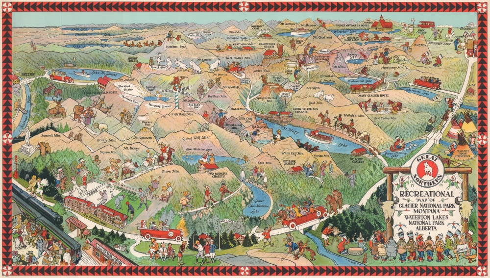

Joseph Scheuerle (March 15, 1873 - March 25, 1948) was an Austrian-American artist, illustrator, and painter. Born in Vienna, Austria, to vacationing German parents, he grew up in Stuttgart, Germany. Scheuerle immigrated to the United States with his family in 1882. The family lived in Cincinnati, Ohio, where Scheuerle's parents enrolled him in school. Once his teachers realized that he spoke almost no English, they sat him in the back of the classroom, where he spent all his time drawing. Then, he attended the Art Academy of Cincinnati and graduated in 1896. After graduation he started working for the Strobridge Lithographing Company, where he made circus and Wild West posters. In 1900 Scheuerle moved to Chicago and continued working as an illustrator. While in Chicago, Scheuerle commenced his series of portraits of Native Americans, meeting and painting the portraits of the performers traveling with Buffalo Bill's Wild West show. Scheuerle traveled to the Pine Ridge Reservation in South Dakota in 1909, where he painted the portrait of several Sioux. Among his subjects was the Lakota leader Red Cloud, who was almost ninety years old. In 1910 Scheuerle began creating work for the Great Northern Railroad, including its iconic mountain goat logo. This led to his first trip to Glacier National Park in during the summer of 1910. Sheuerle took advantage of this trip to visit other Native American reservations and paint portraits of the people he met. Over the course of his career, Scheuerle produced over two hundred portraits of Native American people. He died of a heart attack at home in South Orange, New Jersey. Scheuerle married Carolyn Lohrey in 1904, with whom he had a daughter in July 1906. More by this mapmaker...
Copyright © 2024 Geographicus Rare Antique Maps | Geographicus Rare Antique Maps
This copy is copyright protected.
Copyright © 2024 Geographicus Rare Antique Maps