1905 General Lithographing and Printing Map of Seattle, Washington

Seattle-generallitho-1905
$2,500.00
New Guide Map of Seattle Washington. - Main View
Processing...

1905 General Lithographing and Printing Map of Seattle, Washington

Seattle-generallitho-1905

...while the iron is hot.
$2,500.00

Title


New Guide Map of Seattle Washington.
  1905 (dated)     37.5 x 25.5 in (95.25 x 64.77 cm)     1 : 24000

Description


A scarce large format 1905 city map of Seattle produced by General Lithographing and Printing during one of the city's most momentous decades, defined by ambitious public works projects that reshaped the city and capped by the 1909 Alaska-Yukon-Pacific Exposition. The map is suffused with a sense of change and transience underscored by the surrounding real estate advertisements, enjoining the viewer to strike while the iron is hot.
A Closer Look
The growing city of Seattle is displayed with neighborhoods, streets, and city blocks labelled and concentric circles marking out one-mile intervals from Pioneer Square. Streetcar (solid black lines) and rail lines (black lines with hash marks) are indicated throughout.

Bouncing back from the Great Seattle Fire of 1889, when this map was published the city was booming due in part to the Klondike Gold Rush. Some nearby towns, such as West Seattle and Columbia, were at this time independent but were soon to be annexed by Seattle. Other elements of the map reflect a city in transition, with an eye towards the future.

Most of the Seattle Tide Lands seen here, including Harbor Island, were still in the process of being reclaimed and would not be usable until 1909. Other artificial waterways meant to tame the waters surrounding the city and open up land for development were similarly still in the works. An inset map at bottom left displays a proposed new water supply system from the Cedar River; over the following decade, this plan was realized by carving out a watershed owned by the city of Seattle and completely rechanneling the Cedar River to empty into Lake Washington.

The University of Washington, such as it was, is seen at its present campus, which it relocated to in 1895. The mostly empty university grounds were utilized for the Alaska-Yukon-Pacific Exposition in 1909, after which the number of university buildings on campus increased considerably. Elsewhere, evidence of the city's growth can be seen in neighborhoods with ephemeral names and unnamed parks which never materialized.
Ambitious Public Works
The 'Government Canal' seen here is the Fremont and Montlake Cuts, which today, along with the later Chittenden (or Ballard) Locks (at the Salmon Bay Waterway), link Lake Washington and Lake Union with the Pacific Ocean via a ship canal, a project long discussed and debated but uncompleted at the time of publication. The ultimate realization of the waterways in the following years was due in large part to the guiding hand of City Engineer Reginald H. Thomson, who also championed other public works projects that completely reshaped the city, including straightening and deepening the Duwamish River, a modern sewage and electrical system, and leveling (regrading) of some of the city's larger hills and using the excavated dirt as landfill for seawalls, islands, and expanded waterfront districts.
Publication History and Census
This map was produced by the General Lithographing and Printing Co. in 1905 for M. B. Jackson and Sons Real Estate. Only one other example is known to exist, held by the University of Washington.

Cartographer


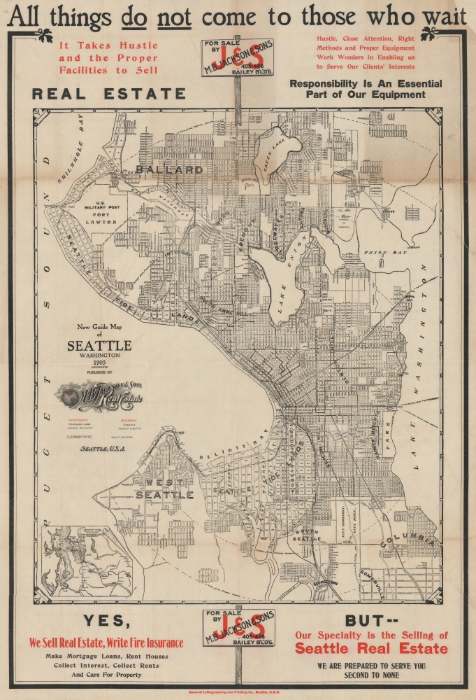
General Lithographing and Printing Co. (fl. c. 1905 - 1911) was a short-lived printer based in Seattle in the early 20th century. Among its few surviving works are a 1905 map of Seattle and an interesting work advocating for Japanese immigration to the U.S. (which peaked in the first decade of the 20th century) published by the Japanese Association of the Pacific Northwest. More by this mapmaker...

Condition


Good. Two-color lithograph. Onion-skin paper. Some toning and wear on old fold lines. Recornered upper right. Laid down on archival tissue.

References


OCLC 21589178.