Title
Portion of Middle Florida, Shewing the Seat of Hostilities between Seminole Indians, and United States.
1839 (undated)
11.25 x 12.75 in (28.575 x 32.385 cm)
1 : 820000
Description
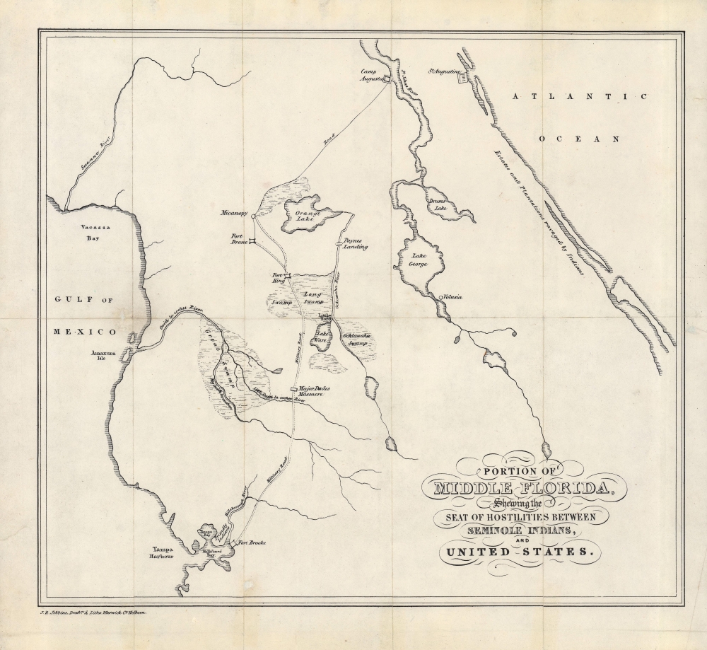
A rare 1839 map of central Florida, produced during the Second Seminole War (1835 - 1842), by John Richard Jobbins for Frederick Marryat's A Diary in America, with Remarks on Its Institutions.
A Closer Look
The map details central Florida, covering from St. Augustine and Fort Brooke to Tampa. A single road with a branch to Fort Drane, built for military use and commonly known as the 'Fort King Highway' or simply the 'military road,' connects Camp Augusta with Fort Brooke. As the map was produced during the Second Seminole War, forts constructed during the war are noted. The site of 'estates and plantations ravaged by the Indians,' a cause célèbre among American settlers, is also indicated.The Second Seminole War
Fought between 1835 and 1842, the Second Seminole War was a conflict between the United States Government and the various American Indian groups known collectively as the Seminole. Fought primarily in peninsular Florida, the Second Seminole War was the most significant of the three Seminole Wars, and the longest Indian War in U.S. history.
The Seminole were a composite nation formed from various southeastern American Indian tribes that were relocated to a large reservation in Central Florida. These included the Alabamas, Choctaw, Yamasees, Yuchis, and Creek peoples, as well as escaped slaves. Most of the land seen here was reserved for the Seminole according to the terms of the 1823 Treaty of Moultrie Creek, negotiated soon after Florida was granted to the U.S. in the Adams-Onís Treaty of 1819. According to the 1823 treaty, the U.S. would provide protection and assistance for the Seminole on the condition that roads could be constructed through the reservation.
Pressure soon mounted, however, as white settlers arrived in Florida in greater numbers. The Seminole lands were seen as a haven for escaped slaves, and white plantation owners claimed that former slaves among the Seminole had been stolen from them (a tenuous claim used to justify their own slave raiding). Matters were not helped by increasing pressure to resettle the Seminole outside of Florida and the election of Andrew Jackson, who had made his name in part through the First Seminole War (fought against Seminole and escaped slaves who had been armed by the British in the last days of the War of 1812).
In 1834 the United States government forced the Seminole to sign the Treaty of Payne's Landing, which gave the tribe three years to move west of the Mississippi. The Seminole, rightly claiming unfair negotiations, renounced the treaty and, instead of moving west, entrenched themselves in the Florida swamps. Skirmishes increased and on December 23, 1835, a column of 110 U.S. troops was ambushed by Seminole warriors and killed almost to a man. Along with raids on nearby plantations, the event incensed the white population, and more volunteers and regular army forces were devoted to the fight. The subsequent war proved long and bloody, with neither side gaining a solid advantage. Ultimately, the superior resources and numbers of the United States military proved decisive. Most of the Seminole were removed to the Indian Territory (Oklahoma) while the remaining Seminole in Florida moved to a large informal reservation located between Lake Okeechobee and Tampa.Publication History and Census
This map was drafted and lithographed by John Richard Jobbins and appeared in Frederick Marryat's book A Diary in America, with Remarks on Its Institutions, first published in 1839. Marryat was an English writer and naval officer who traveled North America in 1837 - 1838. Though best known for his works of nautical fiction (he is credited with inventing the genre), his Diary in America was popular and translated into French and German, with American editions printed in New York and Philadelphia. This map is not independently cataloged with any institution and is scarce to the market. Establishing an accurate census for the Diary in America is difficult given the variety of editions in several languages, but the 1839 London edition (Longman, Orme, Brown, Green, and Longmans) is well-represented in the collections of major research institutions.
Cartographer
John Richard Jobbins (fl. c. 1837 - 1866) was an engraver and lithographer based in London, working out of an office at 3 Warwick Court, Holborn. Despite being rather prolific, producing plates for dozens of works and publishing many standalone prints and broadsides, little is known of his biographical details or training. He was the in-house engraver of the Journal of the British Archaeological Association (and was also a member of the association), which carried a brief obituary upon his death in 1866, noting that he had trained as a land surveyor before taking up printing. The obituary credits him with inventing the technique of etching with a brush upon stone and zinc, a method he used to produce illustrations for the journal. More by this mapmaker...
Condition
Very good. Wear along fold lines with a few areas of loss repaired on the verso.
References
OCLC 30691672.