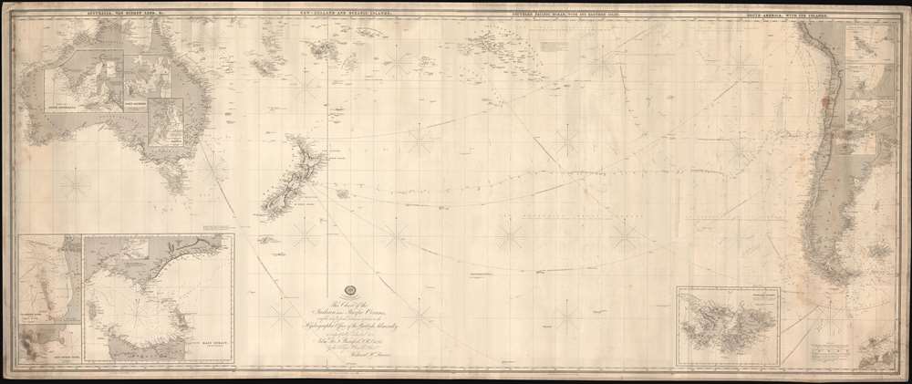
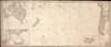
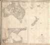
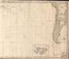
A rare 1880 blueback nautical chart or maritime map of the South Pacific by Richard Holmes Laurie. This map consists of four charts, joined and laid on blue manila paper - designed specifically for navigation of the South Pacific. The chart in aggregate covers from Australia to Buenos Aires, and from Cape York, Australia, to the South Shetland Islands. The present chart offers extensive meandering pencil annotations recording voyages in 1880 and 1881 - apparently around Cape Horn, into the Pacific, and northwards to San Francisco.
Dedicated to Francis Beaufort
Laurie dedicates this chart to the Irish Admiral Francis Beaufort (1774 - 1857), a Royal Naval officer and hydrographer. Beaufort served at sea from 1789, his signature work including detailed surveys of Rio de la Plata and the coast of Turkey. In 1829, he was appointed Hydrographer of the Navy, a post he retained for twenty-six years, overseeing the production of over 1,000 charts. He retired in 1855 as a Rear-Admiral, a KCB, and a Fellow of the Royal Society, the Royal Astronomical Society, and the Royal Geographical Society. Choosing so august a personage to whom to dedicate this chart was no doubt an attempt to confer legitimacy.
Blueback Charts
Blueback nautical charts began appearing in London in the late 18th century. Bluebacks, as they came to be called, were privately published large format nautical charts known for their distinctive blue paper backing. The backing, a commonly available blue manila paper traditionally used by publishers to wrap unbound pamphlets, was adopted as a practical way to reinforce the low-quality paper used by private chart publishers in an effort to cut costs. That being said, not all blueback charts are literally backed with blue paper. The earliest known blueback charts include a 1760 chart issued by Mount and Page, and a 1787 chart issued by Robert Sayer. The tradition took off in the early 19th century, when British publishers like John Hamilton Moore, Robert Blachford, James Imray, William Heather, John William Norie, Charles Wilson, David Steel, R. H. Laurie, and John Hobbs, among others, rose to dominate the chart trade. Bluebacks became so popular that the convention was embraced by chartmakers outside of England, including Americans Edmund March Blunt and George Eldridge, as well as Scandinavian, French, German, Russian, and Spanish chartmakers. Blueback charts remained popular until the late 19th century, when government subsidized organizations like the British Admiralty Hydrographic Office and the United States Coast Survey, began issuing their own superior charts on high quality paper that did not require reinforcement.
Publication History and Census
From about 1841 Richard Holmes Laurie began advertising his twelve-map chart set illustrating the full Pacific and Indian Oceans. The current chart comprises four maps form the set:
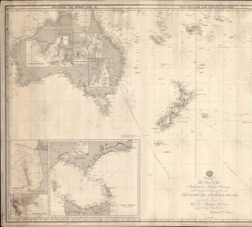
- Sheet 9. - The WHOLE COAST of AUSTRALIA, VAN DIEMEN'S LAND, Sec; with enlarged Plans of Bass's Strait, Port Philip, Cockburn Sound, King George's Sound, Bays of South Australia, Port Jackson, and Entrances to the River Derwent. 7s. 6d.
- Sheet 10. - NEW ZEALAND and OCEANIC ISLANDS. 4s.
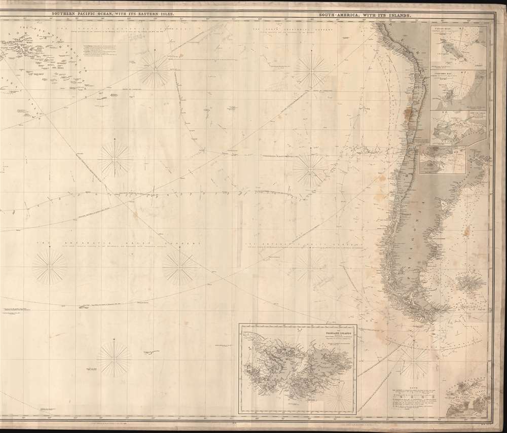
- Sheet 11. - SOUTHERN PACIFIC OCEAN, with its Eastern Islands. 4s.
- Sheet 12. - COAST of SOUTH AMERICA, with its Islands, from Lima to La Plata; with enlarged Plans of Falkland Islands, Port Desire, Port San Carlos, Coquimbo Bay, and Callao Road. 7s. 6d.
The present issue dates to 1880, and was likely published by one of Laurie's heirs, possibly Findlay or one of his heirs. We note no other examples from this edition.
Cartographer
Richard Holmes Laurie (December 2, 1777 - January 19, 1858) was a British map and chart publisher and seller. Born in London to publisher Robert Laurie and his wife Esther Jouret, R. H. Laurie took over his father's share of the Laurie and Whittle publishing firm upon his father's retirement in 1812 and began trading as Whittle and Laurie. After Whittle died in 1818, Laurie continued the business by himself, trading under the imprint R. H. Laurie. During the 1820s and 1830s, Laurie expanded the nautical chart business until he was overtaken by Admiralty charts. Laurie married Susan Ann Coates on February 6, 1814 and later married Mary Ann Dennison on October 15, 1833. He left his business and all his property in trust for his two surviving daughters (both of whom were minors) with his principal engraver, Alexander George Findlay. Findlay continued the business in Laurie's name after acquiring its equity from his daughters. More by this mapmaker...
Good. Original blue backing. Some water stains and wear. Pencil annotations relating to 1880 - 1881 voyages.