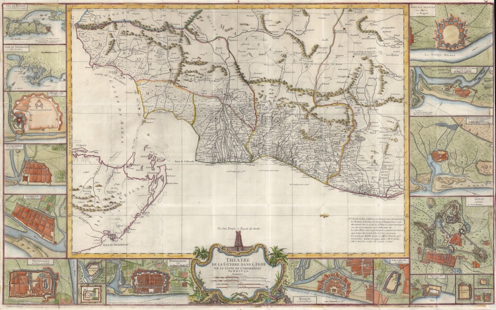
Title
Theatre de la Guerre Dans l'Inde sur la Coste de Coromandel Par M. B. C. T. 1770.
1770 (dated)
22.75 x 37 in (57.785 x 93.98 cm)
1 : 100000
Description
This superb 1770 map of Tamil Nadu, India was engraved in Paris by P. Croisey and is attributed to Jean Bourcet, the chief French military engineer in the city of Pondicherry during the Seven Years’ War. The map, oriented to the west, depicts the Carnatic and the southern Coromandel Coast, the theatre of the Carnatic Wars (1744 - 1763) and the First Anglo-Mysore War (1767 - 1799). Though often fought locally between the Nawabs of the Carnatic and the Sultanate of Mysore, the conflict was essentially between the British East India Company and France.
Proxy Wars
Beginning as an offshoot of the War of the Austrian Succession and extending through the Seven Years’ War, England and France fought in a series of conflicts throughout India. The central and deciding regional fights would all fought in the south, within the bounds of this map. Direct battles between the European powers were rare: the fighting was largely characterized by small, disciplined, and technologically superior European forces employed to shift the balance of forces in local power struggles. Key battles are marked on the map and dated. Those with a French commander present are noted with that officer’s name, and a notation indicating the character of the fight: a French win, a French loss, or a draw.The Fortifications
Nineteen inset views detail the fortifications of cities at play, each associated with a larger power: French, English, Dutch, Danish, or Carnatic. These include Cuddalore, Machilipatnam, Negapatam, Poonamallee, Pondichéry, Bombay, Chingleput, Tranquebar, Tiruchirapalli, Wandiwash, Vishakhapatnam, Gingee, Calcutta, Arcati, Trincomalee, Divicoté, Madras, Carangouli, and the Pagoda of Chalembron. The source for these views is likely Bourcet, the chief French military engineer in Pondicherry, and the figure to whom the overall map is generally attributed.Publication History and Census
This map was engraved and published in Paris, France by P. Croisey, likely based upon cartography provided by Paul Bourcet. The map is rare: British Library, the Sachische Landesbibliothek, the University of Bern, and the BNF. We see trade catalog records for three examples of this map going back to 1994.
CartographerS
P. Croisey (fl. c. 1765 – c. 1800) was a French line-engraver active in the 18th century. Croisey was based in Versailles, France and is best known for his fine portrait of Marie Antoinette, when Dauphiness. He also maintained a location on Rue Haute-Feuille, Pairs. One of his early trade cards survives in which he describes himself as a geographical engineer and engraver of civil and military architecture, topography, and geography. His wife, Madame Croisey was also an engraver, specializing in music and text. He died around 1800. More by this mapmaker...
Jean Claude Bourcet (August 15, 1732 - December 28, 1776) Was a French Officer and military engineer. Bourcet was born in Grenoble, France. He served as chief of fortifications in Pondichéry, the linchpin of France's colony in India during the Seven-Years' War. Bourcet died in Pondichéry. Learn More...
Condition
Good. Recornered with slight manuscript reinstatement of border area. Surface mends at left and right with virtually no loss. Folds reinforced, with few areas of visible wear. Else very good.
References
OCLC 556971834. Gole 69.