This is a 1932 Mary Hall Atwood pictorial map of Los Angeles and vicinity created for attendees of the 10th Olympic Games.
A Closer Look
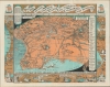
Oriented toward the northeast, the map depicts the region from Ventura and Simi Valley to Basset, Covina, and Azusa, and from Newhall and the Angeles National Forest to Palos Verdes and the Pacific Ocean. Los Angeles proper, situated near the center, is surrounded by other communities, including Van Nuys, Burbank, Glendale, Pasadena, and Long Beach. Both U.C.L.A. and the University of Southern California are labeled, as are the Rose Bowl and the Los Angeles Memorial Coliseum, then known as the Olympic Stadium. A legend along the right border lists all the Olympic events and where they will be held.Scenic Drives
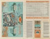
The whole is framed on three sides by smaller pictorial maps illustrating scenic drives. The map on the left traces a route along the coast from Santa Ana south to San Diego and Ensenada, Mexico. The drive along the bottom goes from Los Angeles through San Bernardino to Indio, while the one highlighted by the map on the right extends north from Los Angeles along the coast to San Luis Obispo and Morro Bay. Waypoints along each route are labeled, some of which are illustrated by a vignette, and the distance from Los Angeles to most of them is given in miles. A smaller pictorial map of the Olympic City is printed on the verso.The Depression Olympics
The 1932 Summer Olympics, the Xth Olympiad, held in Los Angeles, were set against the backdrop of global economic depression. Lacking finances, only 37 nations competed, as opposed to the 45 that competed in the 1928 Amsterdam Summer Olympics. Curiously, Los Angeles was the only city that applied to host the Olympics in that year and so was selected by default.Unocal
The publisher, the Union Oil Company of California and Unocal Corporation, was a major petroleum explorer and marketer active from the late 19th century through the early 21st century. It was headquartered in El Segundo, California, United States and was a sponsor of the Xth Olympiad.Publication History and Census
This map was designed and illustrated by Mary Hall Atwood and published by the Union Oil Company in 1932. We note two examples cataloged in OCLC which are part of the collections at the Newberry Library and Stanford University.
Cartographer
Mary Hall Atwood (February 20, 1894 - October 4, 1950) was an American artist who specialized in murals and map-making. Born in Chicago, Atwood studied in Paris at the Academie Julian, where she was a student of Robert-Fleury and Jean Francois Millet. She moved to Los Angeles in the late 1920s and soon gained a reputation for the decorative maps of Southern California, which she called 'Travel and Pleasure Maps'. She was an active member of the California Watercolor Society and in her travels throughout the Southwest United States, completed a mural commission for the Phoenix Rotary Club. Atwood died in Glendale California in 1950. More by this mapmaker...
Very good. Even overall toning. Light soiling. Pictorial map of the Olympic City and other content on verso.
Rumsey 6790.003. OCLC 953572866.