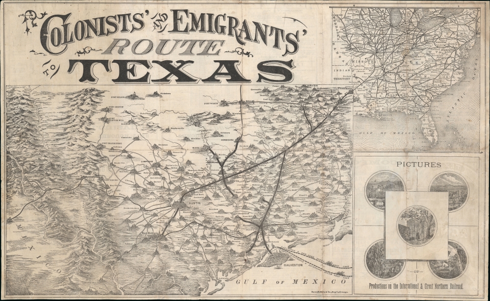
A striking 1877 Rand McNally pictorial map of Texas issued to promote the International-Great Northern Railroad (IGNRR). The map follows in the wake of the post-Civil War Reconstruction Era (1863 - Mar 31, 1877) and illustrates Texas's efforts to promote emigration. The generally successful drive redefined Texas' cultural landscape and helped stabilize the foundering post-war economy.
A Closer Look
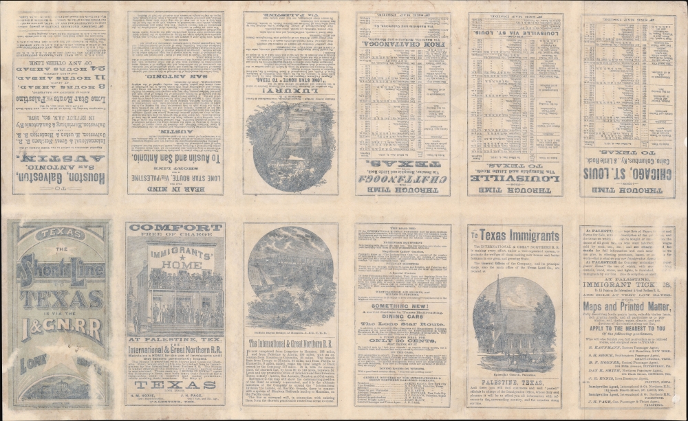
Centered on Austin, coverage extends from Chihuahua, Mexico to Texarkana, and from Fort Belcamp to Laredo. Villages and cities are illustrated pictorially with a distinctly European flair, including hill-like towns with church steeples. Heavy lines emphasize the routes offered by the IGNRR. In the upper right, a general map illustrates connections to other rail lines throughout the eastern United States. Pictures in the lower right illustrate the agricultural bounty of Texas. On the verso, individual panes provide timetables, promotions for the railroad, and enticements to immigrants.Reconstruction and Railroads
Texas was hit hard by the American Civil War (1861 - 1865) wherein its infrastructure, particularly its fledgling railroads, were either stunted or altogether destroyed. Moreover, the Texan economy, heavily dependent upon plantation culture and slave labor, was devastated. What it did have was an excess of free land. The Texas legislature realized they could leverage their greatest asset - real estate - to entice railroad development and emigration. In 1869, Texas amended its constitution to provide extensive railroad grants from public lands. The IGNRR received over 3,000,000 acres.International - Great Northern Railroad
IGNRR was founded in September of 1873 when the 'International Railroad' and the 'Houston and Great Northern Railroad' merged. The IGNRR was based in Palestine, here greatly exaggerated in size, and controlled roughly 1,106 miles of track throughout Texas - with connections to the International Overland Route from Austin to Chihuahua. As part of their mandate, the IGNRR did much to encourage emigration to Texas, offered free or low-cost land, and ran an 'Immigrant's Home' (pictured on verso) in Palestine that acted as a sort of halfway house until emigrants could find a more permanent domicile.Publication History and Census
This map was issued by Rand McNally and Company on behalf of the IGNRR. The verso bears a date of 1878, but it was more likely printed in 1877. Rare. The Texas General Land Office issued an interesting article about the map and offers reproductions for sale - which have found their way into multiple institutions, but originals, as here, are extremely rare. We note examples at the University of Texas Arlington and the Library of Congress.
Cartographer
Rand, McNally and Co. (fl. 1856 - present) is an American publisher of maps, atlases and globes. The company was founded in 1856 when William H. Rand, a native of Quincy, Massachusetts, opened a print shop in Chicago. Rand hired the recent Irish immigrant Andrew McNally to assist in the shop giving him a wage of 9 USD per week. The duo landed several important contracts, including the Tribune's (later renamed the Chicago Tribune) printing operation. In 1872, Rand McNally produced its first map, a railroad guide, using a new cost effective printing technique known as wax process engraving. As Chicago developed as a railway hub, the Rand firm, now incorporated as Rand McNally, began producing a wide array of railroad maps and guides. Over time, the firm expanded into atlases, globes, educational material, and general literature. By embracing the wax engraving process, Rand McNally was able to dominate the map and atlas market, pushing more traditional American lithographic publishers like Colton, Johnson, and Mitchell out of business. Eventually Rand McNally opened an annex office in New York City headed by Caleb S. Hammond, whose name is today synonymous with maps and atlases, and who later started his own map company, C. S. Hammond & Co. Both firms remain in business. More by this mapmaker...
Good. Soiling. Laid down on archival tissue, but verso content remains accessible. Wear on old fold lines.
Library of Congress, G4031.E27 1877 .M5. OCLC 761874406.