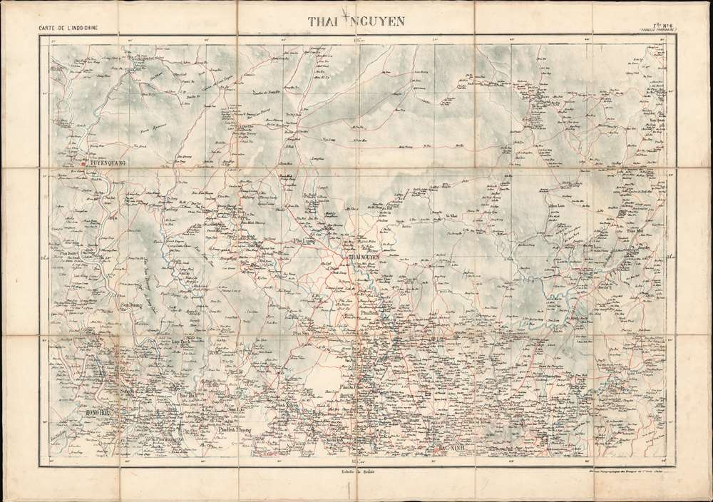
A rare 1895 map of the Thái Nguyên region in northern Vietnam, north of Hanoi. The map was issued by the Bureau Topographique des Troupes de l'Indo-Chine and is sheet 6 of the Carte de L'Indo-Chine, an otherwise lost large-scale French military survey of the region. The area covered here, Thái Nguyên, is a mountainous, midland region. It is the gateway, via road, rail and waterways, for socio-economic exchange with the important Red River Delta. It is also the site of Tam Đảo National Park. The map is the work of surveys completed between 1886 and 1887 by French topographic surveys completed at the order of the Bureau Topographique as well as surveys completed by the 1886 Commission de Delimitation, which determined the Indochina-China border.
Carte de L'Indo-Chine
The Carte de L'Indo-Chine is an elusive but impressive military survey of the entirety of French Indo-China published between 1892 and 1895. Presented on a staggering scale of 1:200000, the full set contained over 50 individual sheets. We have been unable to trace any complete sets, with even a search at the Bibliothèque Nationale de France Catalogue Général (BnF) turning up no other examples of this magnificent production. Nor is it clear if the full survey was completed. What we know is that it was issued by the Bureau Topographique des Troupes de l'Indo-Chine based upon surveys completed by Dominique Eugène Paul Balagny (1863 - 1948) between 1889 and 1991, earlier Indo-chine military surveys, and new surveys completed by Bureau expeditionary teams between 1886 and 1893. We have found but one reference to this work, a vague note in an 1898 collection recording the correspondence of the service during the previous 10 years. That note merely suggests that 1:200000 map was planned as early as 1888. Although all sheets are undated, they were most likely printed in Hanoi after 1890, when the Bureau Topographique acquired a local press. Stylistic variations between maps in the series, for example, how large bodies of water are shaded, suggests that they may have also employed external presses. Publication History and Census
Although undated, this was most likely issued in 1895, in Hanoi, by the Bureau Topographique des Troupes de l'Indo-Chine. The map is sheet no. 6 of a massive 1:200000 topographical survey of Indochina containing at least 50 sheets, of which this is only one of 5 known surviving sheets. No institutional or private holdings have been identified.
Cartographer
Bureau Topographique des Troupes de l'Indo-chine (fl. c. 1886 - 1900) was founded in 1886 in Hanoi. Its first major project was a 1:2000000 map of the entirety of Indochina, for which they drew on source maps created by the Service Hydrographique de la Marine and those created by an expeditionary corps sent throughout the region. Before establishing its own printing facilities in Indochina in 1890, the Bureau Topographique transferred their work back to Paris to be printed by the Service Géographique de l'Armée. In 1890 the Bureau Topographique also began to increase its cartographic output. The Bureau Topographique sent army officers on triangulation and topographic missions in unexplored areas of Indochina throughout the 1890s, some of which proved fatal for the participants. It is unclear when the Bureau Topographique shut down, but no examples of their work postdate 1900. More by this mapmaker...
Very good. Original linen backing stable.