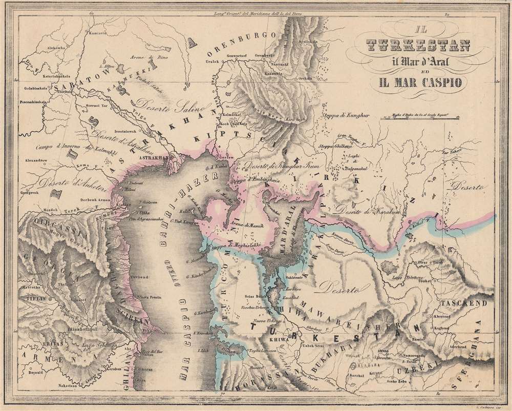
A thorough Italian language map of Central Asia (Turkestan) produced by Francesco Marmocchi for his 1858 work Il Globo Atlante di Carte Geografiche. It portrays the vicinity of the Caspian and Aral Seas at a time when the Russian Empire was beginning a methodical conquest of the entire region.
A Closer Look
Coverage extends from the Caucasus in the west to the Ferghana Valley in the east, and from Orenburg in the north to Bukhara in the south. Aside from the two seas noted in the title, the map is especially detailed in the indication of waterways, including the dozens of lakes amid the steppes of today's central and eastern Kazakhstan. Other ecological features, along with cities and mountains, are also indicated. The location of Bukhara is denoted with a hand-written annotation, most likely a result of the lack of knowledge about the emirate in Europe.
The Aral Sea is seen here before its drastic reduction beginning in the 1960s, due to massive irrigation projects on the lower Syr Darya River (here as Sir Deria), which have contributed to the near-complete disappearance of the lake. Russia's Expansion into Central Asia
Russian contacts with Central Asia predated this map by many centuries and Russian national identity is largely rooted in the relationship with the steppe and interaction (trade, warfare, etc.) with steppe-dwelling peoples. In the 17th and 18th centuries, the Russian Empire established a series of border forts that roughly followed the edge of the forested land before reaching the steppe, also concurrent with the present-day border between the Russian Federation and Kazakhstan. Occasional forays into the steppes were attempted but conquering those territories in any meaningful sense remained elusive.
Using the latest military, communication, and transportation technology, the Russian Empire focused intently in the mid-19th century on subjugating Central Asia. Although the region had lost some of its wealth and luster from the height of the Silk Road, it was still home to powerful states that held their own in tussles with neighboring empires in the 18th and early 19th centuries.
The Russians encountered difficulties in trying to control the region, starting with a disastrous attack on Khiva in 1839 (it was eventually conquered in 1873). Rather than military strategy or technology, the main obstacle was supplying troops so far from the Russian heartland in a region with minimal infrastructure. Getting supplies to the main staging area at Orenburg was difficult enough, but then they needed to be moved across vast distances through desert and steppe. What could not be moved up rivers had to be carried over land, usually by caravans of horses, oxen, and camels, which required their own food and water.
Thus, Russian progress into Central Asia was consistent but slow. Following the Khiva debacle, sights were set on establishing a line of forts along the Syr Darya River, encroaching on the territory of the Khanate of Kokand. This string of forts allowed the Russians to overcome their logistical challenges and expand further into the eastern Kazakh steppe, reaching the portion of Central Asia controlled by the Qing Dynasty by 1851. With this eastern flank secured, the next several decades were spent in conquering Kokand, Khiva, Bukhara, and other territories to the west and south. Publication History and Census
This map appeared as Plate No. 12 in Francesco Marmocchi's Il Globo Atlante di Carte Geografiche, published in 1858, the year of Marmocchi's death. The maps in the atlas employ the plates used in his earlier work Geografia Commerciale, including the title of that work on each map, which may explain the close cutting of the margin here. It was engraved by G. Cattaneo and published by Paolo Rivara in Genoa. This map is not independently cataloged in the OCLC and is very scarce to the market, while the entire atlas is held by the David Rumsey Historical Map Collection, the Newberry Library, and the National Library of Australia.
Cartographer
Francesco Costantino Marmocchi (August 26, 1805 - September 9, 1858) was an Italian geographer. Following in the footsteps of his father, a professor of physics, he began his studies in the natural sciences. He became involved in the Italian nationalist movement and was an associate of Guiseppi Mazzini, leading to his being arrested and briefly imprisoned before being put under house arrest in his hometown of Poggibonsi. He tried to move to Naples under a pseudonym, but was discovered and was forced to leave, settling in Rome. He then focused on publishing, producing translations, original works, and managing a popular broadsheet dedicated to scientific discoveries. More by this mapmaker...
Source
Marmocchi, Francesco C., Il Globo Atlante di Carte Geografiche, (Genoa: Paolo Rivara) 1858.
Good. Even toning. Impression light along the border, especially at bottom.
Rumsey 12235.013.