Title
Map of the Uganda Protectorate to illustrate the paper by Sir Harry Johnston, G.C.M.G., K.C.B.
1902 (dated)
17.5 x 18.5 in (44.45 x 46.99 cm)
1 : 2000000
Description
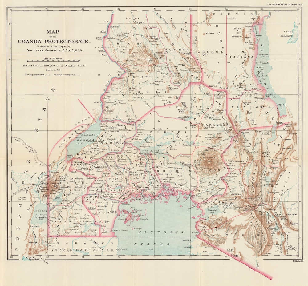
This is a 1902 Royal Geographical Society and Harry Hamilton Johnston 'Scramble for Africa' map of the Uganda Protectorate - including modern-day Uganda and western Kenya. The map was issued to accompany a descriptive article by Johnston, which emerged as the British were working to assert administrative and economic control over the region through the building of the Mombasa-Victoria Railway, the establishment of new administrative zones, and the construction of colonial trade towns.
A Closer Look
The map highlights the British colonial Uganda Protectorate - encompassing a massive territory ranging from the Congo border east as far as Nairobi, Kenya. Lake Victoria (Victoria Nyanza) dominates the bottom border. The region's impressive topography is illustrated, with individual mountain peaks identified - including an impressive Mount Kenya (Elgon). Lake Albert, Lake Kyoga, and Lake Rudolf (Lake Turkana) appear as well. The Nile River runs north from Lake Albert, creating part of the border of the Uganda Protectorate. The Mombasa-Victoria Railway, opened one year earlier in 1901, extends form Nairobi in the lower right to Lake Victoria. Although most of the line was complete when this map was issued, the dashed section here emphasizes that it had not yet reached its terminus at Kisumu. A notation along the route states 'site of projected new capital', which never emerged.Uganda Protectorate
The Uganda Protectorate, established by the British in 1894, marked the beginning of formal colonial rule over the kingdom of Buganda and its neighbors. The era was characterized by administrative, economic, and social changes, as the British sought to consolidate their control through indirect rule, leveraging the existing traditional kingdoms. The introduction of cotton and coffee transformed the local economy, integrating the region into the global markets and altering traditional agricultural practices. The period also saw the establishment of Christian missions, which played a crucial role in education and the spread of Christianity, alongside the introduction of Western legal and administrative systems. Despite these changes, the protectorate era was marked by resistance and negotiation between the British and the local rulers, leading to a complex legacy of colonial rule that shaped Uganda's path to independence in 1962.The Mombasa-Victoria (Uganda) Railway
An ancient Kikuyu prophecy predicted 'an iron snake will cross from the lake of salt to the lands of the Great Lake.' Prophecy became reality in 1896, when the British began construction of an ambitious meter-gauge railway from the Indian Ocean port of Mombasa to the Ugandan city of Kisumu, on Lake Victoria. The construction was plagued by difficult terrain, infectious disease, and the man-eating lions of Tsavo. It also ran excessively over budget, so much so that political critics in London dubbed it the 'Lunatic Express'. Nonetheless, by 1901, the line was complete and proved a strategic coup. The British used railroads as a logistical and tactical tool to assert 'Effective Occupation' during the Scramble for Africa. In this case, the Uganda Railway, as it came to be known despite running almost entirely in Kenya, opened the African Great Lakes region to economic and military development and proved to be the binding linchpin of British East African hegemony. From 1929, the line began running under the management of Kenya Railways as one of the world's great heritage railroads. Passing through some of Africa's most beautiful terrain, travel on the train became a luxury staple for the safari-set, carrying Theodore Roosevelt, among others. Today, although much faded from its colonial glory, the railroad remains little changed, using original tracks, moderately-well maintained original cars, old-world table services, and more.Scramble for Africa
The map is an artifact of the 'Scramble for Africa,' the series of late 19th and early 20th century occupations, usurpations, annexations, divisions, and land seizures by European powers in Africa, here specifically England, Germany, and France. The Scramble for Africa was mainly characterized by heightened occupation and direct ownership of colonial lands. Rivalries and treaties led to a number of new African states, many of which remain, but few of which paid heed to traditional boundaries or cultural distinctions. The Scramble began at the Berlin Conference of 1884, wherein European colonization of Africa was regulated, and the doctrine of Effective Occupation adopted as a baseline for establishing and maintaining colonial claims. According to this doctrine, colonial powers needed to prove 'effective occupation.' This means they needed to establish the existence of treaties with local powers, show that their flags were being flown, build railroads and other infrastructure, or have active forts in the region. The doctrine led to increased European military and economic activity in Africa as colonizers sought to bolster their claims. While this, in part, led to the advancement of infrastructure in Africa, including the construction of modern facilities such as hospitals and railroads, it also led to more intensive direct ownership of colonial lands by Europeans and the exploitation of indigenous peoples.Publication History and Census
This map was drawn by British Africanist Harry H. Johnston and lithographed by H. Manly for publication in the January 1902 edition of The Geographical Journal. We note 3 examples of the separate map in OCLC: Indiana University, Simon Fraser University, and the University of Cambridge.
Cartographer
Harry Hamilton Johnston (June 12, 1858 - July 31, 1927) was a British explorer, linguist, artist, botanist, and colonial administrator who spoke several African languages. Born in London, Johnston attended King's College London and then studied painting at the Royal Academy for four years. He traveled to southern Angola in 1882 with the Earl of May, and he met Henry Morton Stanley in the Congo the next year. During that visit, he became one of the first Europeans after Stanley to see the Congo River above the Stanley Pool. In 1884, the Royal Geographical Society and the British Association appointed Johnston to lead a scientific expedition to Mount Kilimanjaro, during which he concluded treaties with local chiefs (succeeding where German efforts had not), to the advantage of the British East Africa Company to whom the treaties were transferred. Johnston became vice-consul in Cameroon and the Niger Delta in October 1886 and was promoted to acting consul in 1887. Throughout the 1880s and 1890s, Johnston played an important role in Britain's efforts during the Scramble for Africa, spending time in Katanga, Nyasaland, and North-Eastern Rhodesia. Johnston was appointed Knight Commander of the Order of Bath in 1896 and was transferred to Tunis to serve as consul-general, since he was suffering from 'tropical fevers' (malaria). Johnston was sent to Uganda to serve as special commissioner to reorganize the administration of that protectorate in 1899. He published over forty books on African subjects. He retired to Poling, in West Sussex, in 1906, and spent his retirement focused on literary endeavors. Between 1883 and 1915, he published roughly 190 maps of various parts of Africa, most in conjunction with the Royal Geographical Society or British War Office, but some privately with the Bartholomew firm. In 1925, Johnston suffered two strokes, from which he never fully recovered and became partially paralyzed. He died two years later. More by this mapmaker...
Source
Johnston, H., 'The Uganda Protectorate, Ruwenzori, and the Semliki Forest', The Geographical Journal, Vol. XIX No. 1 January 1902, (London: Royal Geographical Society) 1902.
Condition
Very good. Light wear along original fold lines. Small area of reinforcement on verso. Accompanied by Johnston's article.
References
OCLC 49359949, 243538858, 49580317.