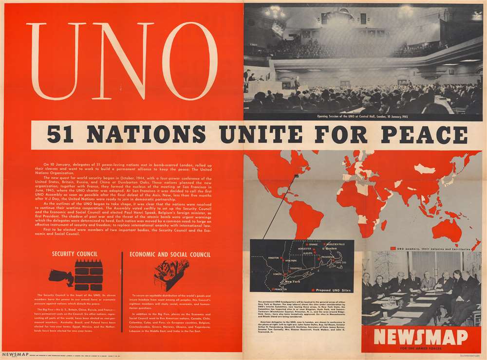
This is a 1946 Army Information Branch Newsmap map of the world celebrating the First Session of the United Nations General Assembly. A map of the world occupies a little less than one quarter of the sheet with the members of the nascent United Nations (U.N.) (and their colonies) shaded red. A black inset focuses on the area from Boston, Massachusetts, south to Princeton, New Jersey, and red stars mark potential locations for the United Nations' permanent headquarters. A photograph of the opening of the session occupies the upper right quadrant, while an image of the U.S. delegation appears below the map in the lower right corner. On the left side, text provides a short history of the creation of the U.N. and the events of the session. Text and graphics in the lower left corner inform the viewer of the existence of the Security Council and the Economic and Social Council.
The First Session of the United Nations General Assembly
The First Session of the United Nations General Assembly took place from January 10 through February 14, 1946, at Methodist Central Hall, Westminster, London. The Security Council and the Economic and Social Council also met periodically during this session. While numerous topics were discussed, perhaps the most important achievement of this meeting was finishing the organizational phase of the United Nations. The Assembly established the Atomic Energy Commission, determined that the official languages of the United Nations would be Chinese, English, French, Russian, and Spanish, and laid the groundwork for how non-governmental organizations would participate with the UN.Verso Content - The Scuttling of the French Fleet at Toulon
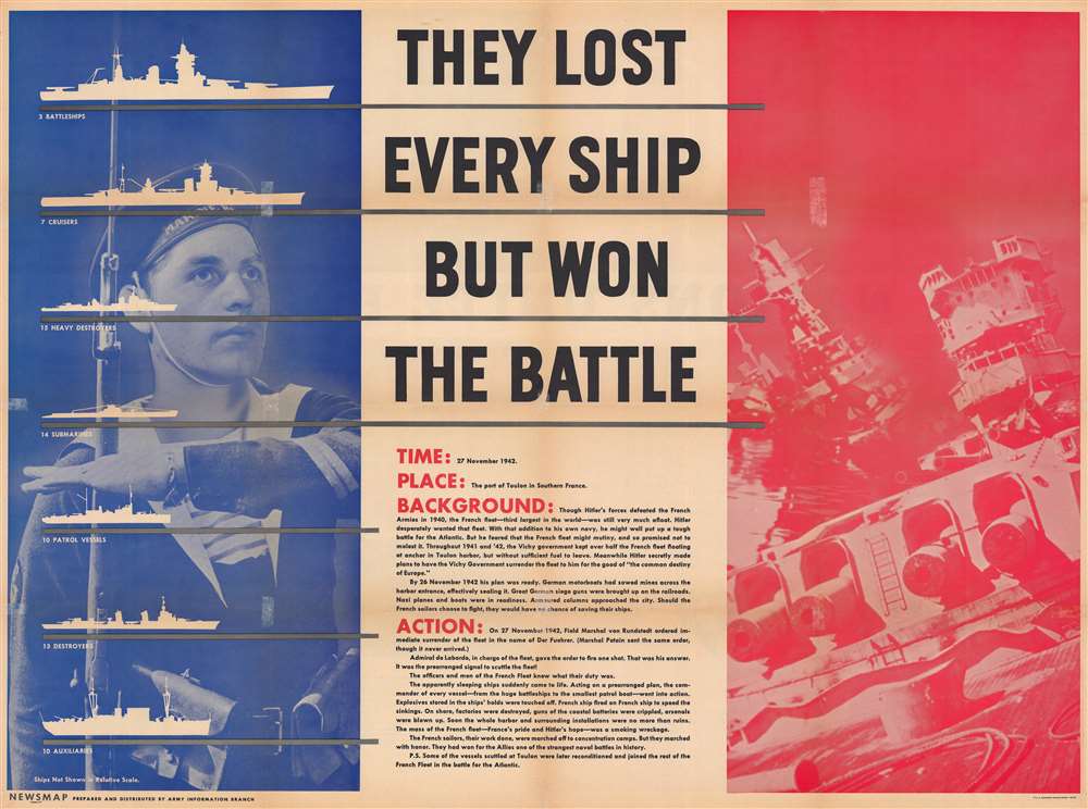
The verso of this Newsmap highlights the scuttling of the French fleet at Toulon on November 27, 1942. After the French signed the armistice with Germany after the Fall of France in 1940, the French navy was confined to harbors in France and the French colonies. Following the Allied invasion of North Africa in November 1942, Nazi Germany invaded the 'free zone' and ended any illusion of an independent France. Most of the French fleet was anchored at the naval base at Toulon and had been ordered by high command to not allow any foreigners (Allied or German) to take control of the fleet. After the invasion of the 'free zone', German forces turned their sights to capturing the fleet at Toulon. German tanks arrived in Toulon around 4 a.m. on November 27 and tried to make their way to the harbor. French forces successfully delayed the Germans long enough that seventy-seven naval vessels were successfully scuttled at anchor. Four submarines disobeyed orders and successfully evaded German ships guarding the harbor and fled to North Africa. All major French naval vessels were destroyed, effectively keeping them out of German control. However, the Germans did manage to capture thirty-nine small ships, although this did not keep the operation from being viewed as a disaster. The present broadside celebrates the French 'victory' at Toulon. Silhouettes of warships, images of burning naval vessels, and a portrait of a French sailor are superimposed over the bleu, blanc, et rouge of the French flag, along with text that declares 'They Lost Every Ship But Won The Battle'.Publication History and Census
Part of the Newsmap series, this map was prepared and distributed by the Army Information Branch in January 1946. We note seven examples cataloged in OCLC which are part of the collections at Denison University, Ohio Wesleyan University, Davidson College, the Library of Michigan, Southern Illinois University and Edwardsville, the Denver Public Library, and the University of Missouri - Columbia.
Cartographer
The Army Orientation Branch (1940 - c. 1949) created special maps for teaching the Army Orientation Course and was based at The Pentagon in Washington, D.C. The Army Orientation Branch was part of the Information and Education Division. More by this mapmaker...
Source
NEWSMAP Series.
Newsmaps were published weekly between April 1942 and March 1946. Their content usually featured world maps, short summaries of the week’s military action, and photographs of troops and materiel. Early Newsmaps were printed on one side only, but, later in the war, they were printed on both sides, with the reverse bearing large-format maps, photographs, or other visual information. Several different versions of Newsmaps were produced: a large domestic version, a smaller overseas version, and an industrial version, which included more information about war production efforts. Two other editions appear in the
United States Government Publications Monthly Catalogs, a 'Newsmap Special Edition' and a 'Newsmap Special Supplement for Special Training Units'.
Per the National Archives and Records Administration, ‘NEWSMAPS were not issued for general distribution. The posters were distributed to military installations, government and civilian groups working on War Department projects, and certain depository libraries, as designate by Congress, and one copy to Congressmen, if requested.’ The importance of the Newsmaps to the Army is related in the 1944 Basic Field Manual for The Special Service Company. The Manual states that as soon as the company reaches its destination ‘the company commander should contact the Special Service Branch in theater of operations headquarters, for copies of the weekly Newsmap.’ Also per the Manual
The librarian should check the weekly Newsmap as soon as it is made available and should post it in a conspicuous place. He should take steps to see that the place where the Newsmap is posted is made known to all troops of the area in which the company or platoon is operating. This can be done effectively through notices in soldier newspapers, verbal announcements by those directly in charge of troops, and by posting announcements on bulletin boards.
Good. Wear along original fold lines. Verso repairs to fold separations. Closed margin tears professionally repaired on verso. Verso repairs to separations at every fold intersection. Slight loss at a few fold intersections. Printed text and images on verso.
OCLC 60931857, 62717479.