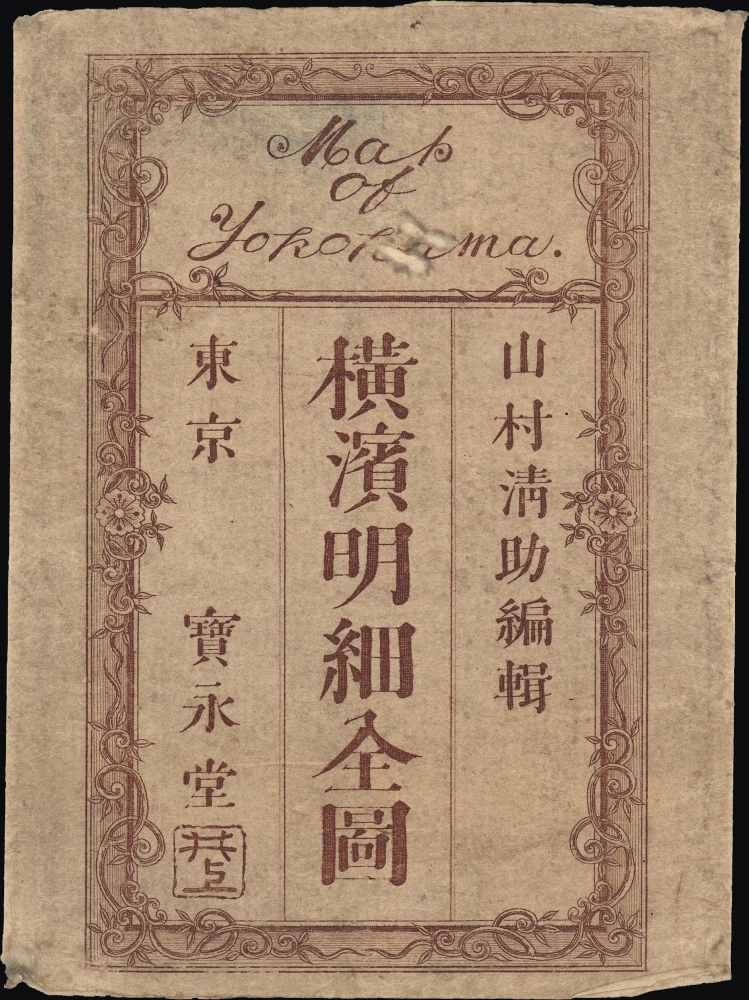
Title
改正橫濱明細全圖 / Map of Yokohama.
1878 (dated)
13.5 x 19.75 in (34.29 x 50.165 cm)
1 : 10150
Description
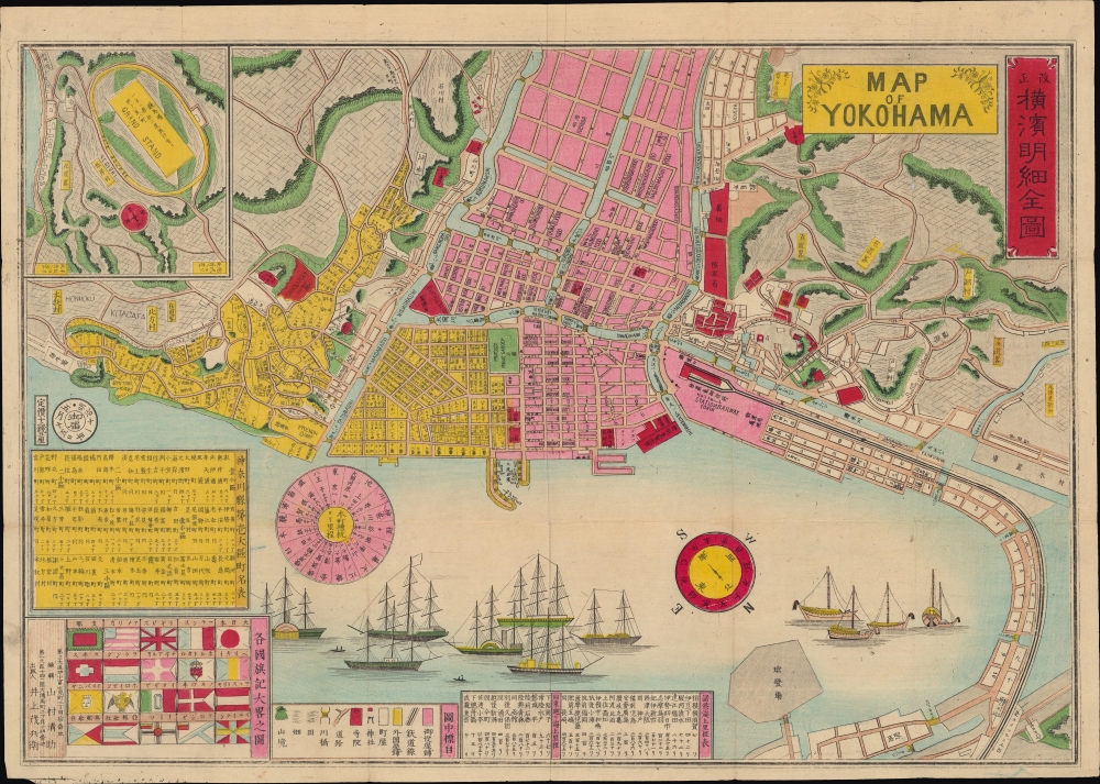
A scarce, colorful bilingual 1878 map of Yokohama, Japan edited by Yamamura Seisuke and published by Inoue Mohei. It depicts the city nearly twenty years after its opening as Japan's main outlet for trade and interaction with the outside world, and demonstrates how internationalized it had become in that short period.
A Closer Look
Oriented towards southwest, the map is interspersed with Romanized Japanese placenames (such as the bridges, as 'hashi' or 'bashi') and English words ('Grand stand,' 'Station railway train'). The foreign words, often with individual letters written backwards, were likely copied from a Western map of the city and transposed rather imperfectly ('Race gourse,' 'Pobuc Garoen'); some are so garbled they are indecipherable. Space limitations also prevented more complete translation or transliteration, as with the building simply labelled 'British' at left (a hospital or infirmary 英病院).
The foreign-inhabited portion of the city is shaded yellow, with addresses of each building recorded in the Western fashion (building number and street name), while the Japanese portion of the city is shaded pink and allows for the location of buildings using the Japanese system of neighborhoods (町) and city blocks (丁目). Buildings belonging to the government or military, as well as those with a public function, such as parks, schools, and temples, are shaded red. These include early industrial efforts, such as an iron works (製鉄所) and a factory producing beacons (燈明臺製造寮), hinting at Yokohama's later economic development. Immediately adjacent to the docks at center is a customs office (稅関). The train station, prominent at right, is notable as the first railway line linking Tokyo and Yokohama had only begun operations in 1872, marking the start of Japan's long association with rail travel.
At top-left is an inset map of Negishi (根岸村), a suburban area beyond the scope of the map notable for containing a Western-style racetrack. At bottom-left, the national and maritime flags of Japan and the foreign nations who operated trading posts at Yokohama are represented. Above the flags is a table, shaded yellow, of the neighborhoods (町), and blocks (丁) of Yokohama, officially known as the 'Large No. 1 Ward of Kanagawa Prefecture' (神奈川県第壱大區). To the right of this list is an interesting, pink-shaded circular graphic constituting a table of distances from Yokohama to other cities in eastern Japan. At bottom, below illustrations of a group of foreign ships in Yokohama's harbor, is a legend and two tables of maritime distances. Yokohama – Japan's Gateway to the Outside World
Although Japan had reluctantly signed a 'Treaty of Peace and Amity' with the United States in 1854, allowing for greater foreign presence and influence in Japan, the terms were quite vague until a subsequent treaty, the Treaty of Amity and Commerce (also known as the Harris Treaty), was signed in 1858, opening Japanese ports to foreign trade. Other foreign powers piled into Japan to sign similar treaties stipulating rights for their nationals to trade and reside in certain Japanese ports. The most important of these 'treaty ports' were Nagasaki and Yokohama, the former having been a major port for centuries, the latter much less so.
The foreign powers demanded a port near Tokyo, understanding that the capital itself was not an option. Yokohama was primarily chosen because the most obvious choice, Kanagawa-juku, a nearby coastal station on the Tōkaidō, was opposed by the Shogun. Much like Shanghai in China, Yokohama grew rapidly and became the main conduit for the exchange of people, goods, and ideas between Japan and the outside world. Aside from Western traders, Chinese merchants and workers also resided in Yokohama in large numbers, establishing an important Chinese community there, still the largest Chinatown in Japan.
Woodblock artists rushed to depict the new visitors, who were regarded with both curiosity and revulsion, but in either case were an object of keen interest throughout Japan. These prints were so popular that they spawned an entire genre, known as Yokohama-e (橫濱繪).
As the city itself was a product of the treaty port system, Yokohama was quick to embrace foreign technology, and Japan's first major rail line was opened from Yokohama to Edo (by then renamed Tokyo) in 1872. Eventually, Yokohama would grow to swallow up Kanagawa-juku and other nearby towns, becoming the capital of Kanagawa Prefecture and the second largest city in Japan. Publication History and Census
This map was edited by Yamamura Seisuke (山村清助) and published by Inoue Mohei in 1878 (Meiji 11). The title notes the outfit Hōeidō (寶永堂), which was closely associated with Inoue, to the extent that it might have been his own operation. Only one example of this map is noted in institutional holdings, at the National Diet Library. The present map looks to have been the basis for Sugiura Tomekichi's 1892 map of Yokohama (also sold by us).
CartographerS
Inoue Mohei (井上茂兵衛; 1852 - 1927) was a Japanese cartographer and publisher active in the Meiji period. At the end of the nineteenth century, he served as the head of the Tokyo Jihon Engraving Sales Association (東京地本彫画営業組合), a descendent of the publishers' guilds (地本問屋) that produced ukiyo-e, popular literature, and other essential cultural production of the Tokugawa era. Inoue generally produced nishiki-e (錦絵), an elaborated form of ukiyo-e that were very popular during the Meiji period and which often depicted the introduction or influence of foreign technology, fashion, and ideas in Japan. More by this mapmaker...
Yamamura Seisuke (山村清助; 1847 - 1899), which can also be read Yamamura Kunitoshi or Yamamura Kiyosuke, also known as Utagawa Kunitoshi, was a Japanese woodblock print artist of the Meiji period. As his professional name suggests, he was a member of the esteemed Utagawa school, studying under Utagawa Kunisada I (1786–1865), Utagawa Kunitsugu (1800–1861), and Utagawa Kunisada II (1823-1880). His career overlapped with the opening of Japan to the outside world, and his work falls squarely within the Yokohama-e and kaika-e genres, depicting foreigners and new technologies in Japan, above all in Yokohama. Learn More...
Condition
Very good. Light wear along original folds.
References
OCLC 675574381.