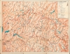
A colorful 1954 map of the northern portion or 'North Country' of Yosemite National Park, including mountains, lakes, reservoirs, and hiking trails, made by Lewis W. Clark.
A Closer Look
Covering the northern portion of Yosemite National Park and its environs, the map extends from the vicinity of Emigrant Meadow and Emigrant Lake in the north to Mather and Tenaya Lake in the south, taking in the Hetch Hetchy and Eleanor Reservoirs, critical to the water supply of San Francisco. Ranger stations, camps (including official National Park Service campsites), trails of various types and quality (including the John Muir Trail, which joins the Tuolumne River Trail), mountain passes, roads (paved and dirt), glaciers, sites for fishing, and other features are noted throughout. Mountains, lakes, rivers, and passes are labelled with their elevations noted.
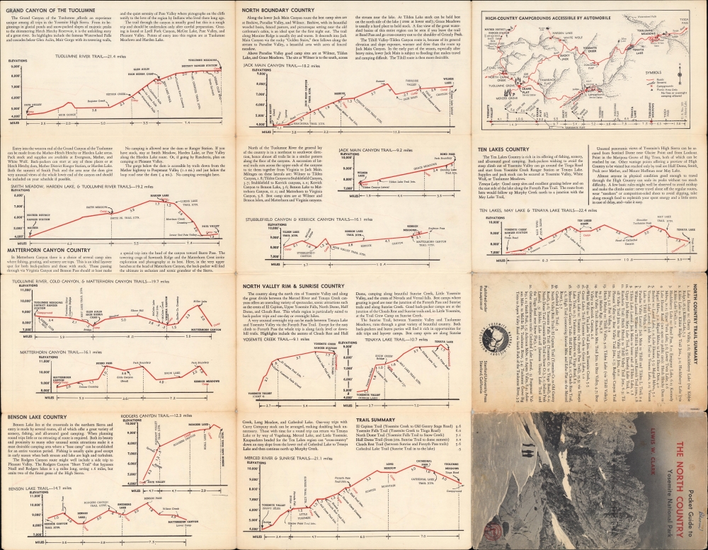
On the verso, a series of hikes are displayed in profile to illustrate changes in elevation. Above each chart is a brief description of the hike, its highlights, potential problems, and other important information. A map at top right focuses on high country campgrounds accessible by automobile. The verso also includes the back of the outside cover of the map when folded, which lists the main trails covered in the recto map.Hiking the High Sierra
Hiking has been a popular means of enjoying nature and getting around in the High Sierra of California for well over a century, and in fact much longer when considering the history of Native Americans in the region. Following the California Gold Rush, more and more tourists came to Yosemite and surrounding areas to experience the remarkable natural beauty there. Among them were John Muir and Galen Clark, who became enamored with the region and dedicated their lives to studying and preserving it. In 1864, Congress passed the Yosemite Grant Act, which set aside lands to be protected by the State of California (though the state did not do a stellar job in this regard) and laid the groundwork for the creation of Yosemite National Park twenty-five years later. As more migrants moved to California, hiking in the High Sierra became an increasingly popular and accessible leisure activity. More trails were designated and maintained, including the John Muir Trail (constructed between 1915 and 1938) and the Pacific Crest Trail (designated in 1968 and completed in 1993, following the John Muir Trail in the area seen on this map before turning north to Benson Lake). Publication History and Census
This map was prepared by Lewis W. Clark and published by the Stanford University Press in 1954. It is one of a series of three books, the other two being Pocket guide to the South Boundary country (1955) and Pocket guide to the High Sierra camp areas, Yosemite National Park (1953). We note the presence of the present map and guide in the holdings of twelve institutions in the OCLC.
Cartographer
Lewis W. Clark (fl. c. 1952 - 2002) was an author of guides and maps relating to the Sierra Nevada of California, including Yosemite National Park, Mount Whitney, Sequoia and Sequoia and Kings Canyon National Parks, Mammoth and Mono Lakes, and the John Muir Trail. Little is known of his life and work aside from these publications. More by this mapmaker...
Good. Wear along original folds. Several small tears professionally repaired. Pinholes areas of loss at fold intersections.
OCLC 64095389, 54783326.