
1646 Dudley Nautical Chart of the Pacific w/ Coast of California

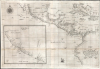

Carta prima generale d'America dell'India Occidentale e Mare del Zur.
Earliest published sea chart focusing on the California coast!
- Digital Map Information
- Suitable for large format printing
- File Size: 26.19 MB
- File Type: ZIP / TIFF
- ICC color profile embedded
- Delivered instantly via download link
Earliest published sea chart focusing on the California coast!
This is the 1646 first state of Robert Dudley's chart of the middle part of the Americas, illustrating the proximity of the Caribbean Sea and the Pacific Ocean and emphasizing the narrow parts of Central America dividing the two bodies of water. The chart features the western part of the Caribbean, but it is particularly noted for being the first printed sea chart to focus on the Pacific coast, including California. It is, along with Dudley's more narrowly focused charts, the first printed chart of the West Indies and South Florida to employ the Mercator Projection. An inset chart in the lower left focuses specifically on the coast of California, from Baja to Cap Mendocino.A Closer Look
The main chart presents the Americas from 27º north to 10º south, and reaches as far west as the tiny Roca Partida, and to Hispaniola in the east. The chart embraces the Pacific coast as far north as the Baja California Sur, inclusive of coastal Mexico and Central America, and reaching down the South American coast to about halfway down the coast of Peru. Dudley's charts, in addition to the employment of the Mercator projection, were the first printed charts to include prevailing winds and currents; these are evident here, as well as shoals and other navigational hazards. There is minimal interior detail - these are nautical charts, focusing on coastal information - but Mexico City is noted, as well as a mountain in southern Mexico: 'M. Ecarepec,' possibly referring to the Oaxacan highland town Santa Maria Ecatepec. Dudley's manuscript charts (which survive in the Bayerische Staatsbibliothek in Munich) name this mountain 'Tecoantepec.' Dudley hyphenates it, so 'Ecarepec' here might be a mistranscription of 'antepec.' 'Tecoantepec' is quite close to the actual name of the isthmus in which this mountain is shown: Tehuantepec. While the Isthmus of Tehuantepec in fact has no mountain in it, it was nevertheless an important feature, since this isthmus represented the narrowest land crossing between the Gulf of Mexico and the Pacific Ocean.California Coast
The large inset of California is important in and of itself, being the first printed chart of this coastline. It presents the California coast from Cap Mendocino in the north, to 'Plaias' in the south; its southernmost latitude is 27º north, consistent with the northern limit of the main chart (which also names 'Plaias' in this location). At about 30º appears a gap in the coast labeled 'Golfo Profondo,' together with a note: 'This gulf has recently been reported as very large but has not been well explored'. At the north end of the gulf is 'Capo Engaño,' while the south is marked with 'I. de Cedros' and 'P. de S. Bartolomeo.' Since the Isla de Cedros is quite accurately placed (it, in actuality, is located at 28º north, quite close to its position on the chart), this 'Golfo Profundo' is the first printed representation of Sebastián Vizcaíno Bay, on the Baja coast. The written account of the 1602 Vizcaíno voyage had stated that the head of the bay could not be seen, and this is reflected both in the text of the map and in the uncertain, dotted depiction of the bay further inland. Contemporary maps such as the 1625 Briggs and 1626 Speed maps place a 'B. De Francisco' between Capo Engaño and P. de S. Bartolomeo, a tantalizing similarity to San Francisco but clearly not the same place, as San Diego appears to the north with a reasonably accurately placed 'I. de S. Caterina'.California-as-an-Island
By the time Dudley produced this chart, both Dutch and English mapmakers had begun to embrace the idea of an insular California. Dudley's Pacific nomenclature mainly resembles that of John Daniell's 1637 manuscript chart, whose Spanish toponymy reflects Sebastián Vizcaíno's official chart of his 1602 voyage, which pre-dated the California-as-an-island canard by more than twenty years. Daniell's chart clearly presents Baja as a peninsula. This chart's Sebastián Vizcaíno Bay, appearing as it does incomplete and in mystery, has sometimes been considered an allusion to the California-as-an-island myth, but it appears to be an irrelevance here. The mouth of the Gulf of California appears on the main map, not the inset, and the placement of the speculative bay is considerably north of that. At best, Dudley's chart can be said to reveal nothing with respect to the question of California's insularity: the composition of the main chart does not reveal the upper reaches of the Gulf of California at all. The California coast beyond Cap Mendocino trails off without resolution, albeit at an angle reminiscent of the upper coastline of the island of California as presented on the Briggs and the Speed. Dudley's manuscript charts show that while he wrestled with modern representations of the Pacific Coast and their incompatibility with earlier models, he was not interested in the California as an island myth. While his manuscripts include many variations on the Pacific Coast to the north, two include the Gulf of California, and both unambiguously present Baja California as a Peninsula, not an island at all.The chart discusses divergent opinions on the correct latitude of Cape Mendocino, which it plots at about 43º N latitude, but includes a note stating: 'Some believe Cape Mendocino is at 41º N Latitude.' The actual latitude of the cape is just above 40º N.
Among the important coastal cities and bays are 'P. dell nuovo Albion scoperro dal Drago C. Inglese' (Point New Albion discovered by the English Captain Drake), 'P. di Moneerei' (Monterey Bay; plotted just below 37º N latitude), the Channel Islands off Santa Barbara, and 'P. di S. Diego' (San Diego; plotted just below 35º N latitude.
A large Quivira - the legendary city said to possess enormous wealth - which by this time had captured the imaginations of Europeans for over a century, and would persist on maps for the rest of the 17th century, is placed inland.
Passage to the Pacific
We do not see a direct source for Dudley's West Indies, but it does not resemble the Dutch charts of Blaeu and Gerritsz. While it is not identical to any of the surviving manuscripts of the Thames cartographers, it more closely resembles these, particularly in its distinctive (albeit incorrect) presentation of Lake Nicaragua as a bay opening to the Caribbean. A lost Daniell or Comberford chart might be a good candidate for a source. This tantalizing water passage through Nicaragua between the Pacific and the Caribbean may have been, for Dudley and contemporary readers, the most important feature of this chart: a possible easy passage from the Atlantic to the Pacific. Dudley's manuscript chart of this region includes the Italian note that 'Some maps show Lake Nicoragua with two long islands in the middle, others are sure that the country is low and flooded.' The manuscript quite clearly presents the lake model, as here.Publication History and Census
This chart was prepared by Englishman Robert Dudley, then residing in Florence, and was engraved by Antonio Francesco Lucini in 1646 for inclusion in Dudley'sDell'arcano del mare. (The general charts such as this were among the first charts actually executed for the 1646 first volume of Dell' Arcano Del Mare; the Carti Partocolari mostly appeared in volume 3 of the work, published 1647). This map is scarce, only being independently cataloged in the OCLC among the holdings of the University of Michigan and the Biblioteca Nacional de España, while the entire Dell'arcano del mare is somewhat more widely distributed, though still quite rare.Cartographers
Sir Robert Dudley (August 7, 1573 - September 6, 1649) was an English explorer and cartographer, the publisher of the Dell’Arcano de Mare, one of the greatest nautical atlases of all time. He was the illegitimate son of Robert Dudley, 1st Earl of Leicester (a favorite of Queen Elizabeth I) and Douglas Sheffield, the widow of John Sheffield, 2nd Baron Sheffield. In 1594, Dudley led an expedition across the Atlantic, with the intent of harassing Spanish merchantmen. His expedition met with a series of misfortunes, but successfully returned to England the following year. In 1596, Dudley joined an expedition led by Robert Devereux, 2nd Earl of Essex, against Cadiz. He served as the commander of the Nonpareil, and was knighted for his conduct in the capture of Cadiz. In 1603, Dudley made an attempt to establish his legitimacy at court and gain several inheritances, after being (possibly erroneously) informed that his parents had been secretly married. No concrete proof of the marriage could be furnished, thus the judgement was handed down against him in May 1605. Dudley left England in July of the same year, with his lover and cousin Elizabeth Southwell, who was disguised as his page. They married in Lyon in 1606 having received a papal dispensation. The couple settled in Florence, where Dudley began using his father’s title, Earl of Leicester, and his uncle’s, Earl of Warwick. In Florence, Dudley designed and built warships for the arsenal at Livorno and became a naval advisor to Ferdinand I, Grand Duke of Tuscany. In 1607, James I revoked Dudley’s travel license once ordered that he return to provide for his deserted wife and family. Dudley refused, was subsequently labeled an outlaw, and his estate was confiscated. By far Dudley’s most important work was the Dell’Arcano del Mare (Secrets of the Sea). His most celebrated achievement, is the atlas of sea charts of the world which accompanied the work. This maritime atlas was the first nautical atlas of the entire world in print, the first made by an Englishman, the first to show prevailing winds and currents, and the first to use the Mercator projection throughout. Further Details...
Antonio Francesco Lucini (January 1, 1610 - 1661), a.k.a. Anton, was an Italian engraver and printmaker. Lucini was born in Florence born in 1605. Lucini initially studied engraving with Stefano della Bella (1610 - 1664) under Jacques Callot (c 1592 - 1635), who lived in Florence from 1612 to 1621. He is recorded in 1616 as Callot's assistant in Florence. After 1621, he joined flowed Callot in Nancy to continue his training. He returned to Florence sometime before 1631, when he published a series of plates on the Great Siege of Malta. He is best known in cartographic circles as the engraver for Sir Robert Dudley's seminal maritime atlas Dell'Arcano del Mare (Of the Mysteries of the Sea), published in Florence in 1645 - 1646. The 200 engraved plates and 146 charts which Lucini produced for Dudley occupied 12 years occupied 12 years of his life and consumed some 5000lbs of copper. The engravings exhibit Lucini’s masterful craftsmanship and are outstanding examples of Italian Baroque engraving. Indeed, while Dudley was a master chartmaker, it is Lucini's virtuoso engraving and fine calligraphy that most define Dudley's work. Further Details...
Source
Dudley, R., Dell'Arcano del Mare, (Florence: Francesco Onofri) 1646.
Dell’Arcano del Mare (Secrets of the Sea) is a six volume 17th century maritime encyclopedia by English nobleman Sir Robert Dudley (1573 - 1649). It is considered to be one of the most important maritime atlases of all time, the first of its kind in print: the first sea atlas to treat the entire world (not just Europe), the first by an Englishman, the first to illustrate prevailing winds and currents, and the first to universally employ a Mercator projection. The charts themselves are notable for being all new works, created by Dudley based upon a lifetime of collecting maritime data. All of the roughly 130 known charts in the Dell’Arcano del Mare were engraved in the Italian baroque aethetic by Antonio Francesco Lucini, a Florentine master engraver. It is said that the work took Lucini 12 years and consumed more than 5000lbs of copper. It was published in Florence between 1645 and 1646 in six folio volumes. Another edition was issued in 1661 but contained fewer charts.
Condition
Very good. Reiniforced at horizontal fold; wear at junctures of folds with minimal loss. Margin reinstated at insertion point.
References
Wagner, H. R., The Cartography of the Northwest Coast of America to the Year 1800, #350. cf. Leighly pp. 36-7; Wendt, Plate 10. OCLC 879247783, 431588327.