
1939 Brooklyn-Manhattan Transit Map of the BMT Subway for the 1939 World's Fair

This item has been sold.
BMT Lines Rapid Transit Division.
Ferrying Passengers to the World's Fair.
Choose a Collection:
- Digital Map Information
- Suitable for large format printing
- Full resolution TIFF file
- ICC color profile embedded
- Delivered instantly via download link
This Item
Enquire
Ferrying Passengers to the World's Fair.
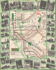
This is a 1939 Brooklyn-Manhattan Transit Corporation (BMT) map of the BMT subway system promoting ridership to get to the 1939 New York World's Fair. The fair saw the introduction of express service on the Flushing Line (now the 7 train of the NYC Subway), then shared between the BMT and the Interborough Rapid Transit Co. (IRT), which was one of the main means by which attendees reached the fairgrounds.A Closer Look
The map depicts the region from Manhattan to Jamaica in Queens and from the East River to Coney Island. Very few locations around the city are labeled, although a few, such as the Empire State Building, Radio City Music Hall, and Brooklyn College, are illustrated in profile. The whole is surrounded by a green border overlaid by photographs of numerous New York City landmarks, including the Empire State Building, Coney Island, Rockefeller Center, Times Square, the New York Public Library, and Coney Island.History of the BMT
The BMT was incorporated in 1923 to take over the assets of the Brooklyn Rapid Transit Company, which went bankrupt in 1919. The system blended subway lines and elevated lines, which this map differentiates through color. Express and local station transfers are also differentiated, and each stop along all the lines is labeled. The Long Island Railroad is also illustrated, since it connected to the BMT system at Atlantic Avenue in Brooklyn and at Woodside in Queens.The 1939 - 1940 New York World's Fair
The 1939 - 1940 New York World's Fair took place in Queens at Flushing Meadows Corona Park, with the opening coinciding with the 150th anniversary of George Washington's inauguration. During its two exhibition seasons, over 44 million people attended, making it one of the busiest world's fairs of all time. It was also the second-most-expensive World's Fair in the United States, behind the 1904 Louisiana Purchase Exposition in St. Louis, Missouri. With a focus on the future, Art Deco and streamlined design dominated, from architecture to automobiles, sculpture, and interior design. Particularly memorable were the Trylon and Perisphere, the symbols of the fair (in the upper-right corner here), and General Motors' pavilion, designed by Norman Bel Geddes (1893 - 1958), titled 'Futurama,' which is credited with introducing the notion of a national network of automobile expressways to the American public.The government pavilions reflected the geopolitics of the era, with the Italian, German, Japanese, and Soviet governments spending lavishly to outdo each other in terms of grandiosity. Other nations tried to use the fair to attract attention and gain support in the United States, including Poland and a Jewish Palestine pavilion, one of the best attended of the entire fair. World War II began four months after the fair opened, and many of the displays were affected, particularly those pavilions of countries under Axis occupation. After the fair closed in 1940, many of the European staff were unable to return home, so they stayed in the United States.
This map was prepared to promote not only the BMT and the world's fair, but specifically the express service, which was inaugurated on April 24, 1939. At this time, the BMT and IRT shared track east of Queensboro Plaza, and the two companies had to coordinate in order to ferry the large volume of passengers to the fair from their respective networks in Manhattan and other boroughs.
Publication History and Census
This map was created and published by the Brooklyn-Manhattan Transit Corporation and printed by the Tabard Press, Inc. in 1939 (dated '4-39' on the verso). It is noted among the collections of nine institutions in the OCLC and is also held by the David Rumsey Historical Map Collection.Condition
Good. Slight loss, reinstated, at center fold intersections. Slight margin loss at some fold endpoints. Stabilized.
References
Rumsey 9992.001. OCLC 184990505.