
1926 McCandlish Manuscript Bootlegger's Map of the United States

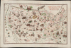
Bootlegger's Map of the United States.
Only Known Manuscript Example of Classic Pictorial Map.
- Digital Map Information
- Suitable for large format printing
- Full resolution TIFF file
- ICC color profile embedded
- Delivered instantly via download link
Only Known Manuscript Example of Classic Pictorial Map.
This is a unique example of Edward McCandlish's famous 1926 Bootlegger's Map of the United States, here presented in manuscript, drawn on linen rather than printed. Produced at the height of Prohibition, the Bootlegger's Map is one of the great pictorial maps of its era.A Closer Look
The map covers the Continental United States with portions of Canada and Mexico. Illustrations throughout poke fun at local culture, customs, and stereotypes in a fashion common to pictorial maps of the era. But many of these illustrations and the modified placenames, such as Lake Champagne for Lake Champlain and Chi-Keg-O for Chicago, are jokes about alcohol, bootlegging, and Prohibition. A scale at bottom-left measures different volumes for liquids, while the compass rose ('pints of the compass') and the map's subtitle ('Honi soit qui mal y pints!') include additional alcohol references.Prohibition: The Great Experiment
Prohibition in the United States (1920 - 1933) was a nationwide constitutional ban on the manufacture, sale, and transportation of alcoholic beverages, enacted through the 18th Amendment and enforced by the Volstead Act. Intended to curb alcoholism, reduce crime, and strengthen public morals, it instead triggered a vast illicit liquor industry, fueling the rise of speakeasies, bootlegging networks, and powerful organized crime syndicates such as those led by Al Capone. While some rural and religious communities embraced the reform, many urban Americans openly defied it, and uneven enforcement bred corruption and public cynicism. The policy ultimately proved unpopular and ineffective, especially amid the hardships of the Great Depression, leading to its repeal by the 21st Amendment in 1933 - the first and only time the U.S. has reversed a constitutional amendment.Publication History and Census
The publication history of the Bootlegger's Map is quite obscure but can be traced to a double-page cartoon produced by McCandlish in 1926 for the Washington Post, where he was working as the lead cartoonist, though his work hitherto had been squarely geared towards children. By the late 1920s, McCandlish had relocated to Detroit to work as the head cartoonist for the Detroit Free Press, and a local publisher, the Griswold Press, issued the Bootlegger's map separately in 1928, which is the edition most often encountered (not always dated). This edition of the map generally includes a claimed copyright date of 1926, with McCandlish's name at the bottom left, though McCandlish may not have filed for copyright until 1930. Various states of this edition appear, often with brewers' advertisements in the bottom-left corner. The map appears to have been issued by other publishers around 1930, and its popularity increased as Prohibition ended and in the years after its repeal. A third edition (second separately issued edition), printed in color and with a similar spirit and appearance, though with new content, was published in 1944 as Bill Whiffletree's Bootlegger's Map of the United States (Hagstrom).In any event, the present example is fully in manuscript, drawn directly on linen. Aside from being drawn in color, it matches the Bootlegger's Map issued by Griswold Press (see Rumsey 6870.000) almost perfectly, though close inspection reveals very minor differences, such as the end of the barrels held by the bootlegger figures to the left of the title being circles within circles rather than straight lines. We are unaware of any other manuscript examples of this map. The map is not signed, but may have been a proof draft of sorts for McCandlish. If not done by McCandlish himself, it was certainly meticulously copied and hung in a speakeasy for amusement, as the Prohibition-era printed issues of McCandlish's map generally were.
Cartographer
Edward Gerstell McCandlish (March 10, 1887 - December 4, 1946) was an American artist, craftsman, toy-maker, and jack-of-all-trades. Born in Piedmont, West Virginia to Upton Beall McCandlish (1848 - 1915) and Margaret Lindsay Landstreet McCandlish (1855 - 1919), not much is known about McCandlish's childhood. He attended Maryland Agricultural College, the Philadelphia Academy of Fine Arts, and another professional art school in Baltimore. It is said that, early in his life, McCandlish worked as a sailor, lumberjack, and highway laborer. He established himself as a toy-maker in Piedmont and Hancock, West Virginia in the years leading up to World War I. By June 1917, when he was drafted into the 116th Engineers in the U.S. Army, he had moved to Baltimore, Maryland and was working as a painter at a local steel works. McCandlish spent most of his time with the Allied Expeditionary Force (A.E.F.) in France working on camouflage (which was hand-painted at the time) and in painting sets for A.E.F. theatre productions. After returning to the U.S., he began teaching art to wounded and disabled veterans at St. Elizabeth's Hospital in Washington, D.C., and was active in the American Legion Veterans' Organization. After a move to Staten Island, New York, McCandlish and his wife Maybelle Bowen (1899 - 1973), whom he married in July 1919, moved to Stonington, Connecticut, where McCandlish established a new toy company, the Character Toy Guild of Stonington. He received copyrights on several of his new toys in June 1920. During the 1920s and 1930s, McCandlish worked as a cartoonist, illustrator, and children's columnist for the Detroit Free Press and the Washington Post, during which time he and his family lived in Northville and Ann Arbor, Michigan. By 1940, the McCandlish family (which now included seven children) had moved to Van Wert, Ohio, and would soon move to Geneva, New York. While in Geneva, in April 1941, McCandlish received a patent for a new roller skate design. By October 1942, McCandlish had elected to forego life as a commercial artist and instead took a job working at one of Curtiss-Wright's aircraft factories in Buffalo, New York. By early 1945, McCandlish had again moved on, after accepting the position of promotion director of the radio station WHEB in Portsmouth New Hampshire, a position he held until August 1945, when he resigned to form a new company, Allied Arts Inc. He is known for two important pictorial maps, the 'Bootlegger's Map of the U.S.' which went through several editions from about 1920 to 1944, and the exceedingly rare 'Ration Map of the U.S.' published in 1944. He died suddenly on December 4, 1946 near North Brookfield, Massachusetts, and was buried at Arlington National Cemetery. Further Details...
Condition
Very good. Drawn on cloth.
References
Barron, R., 'US Comic Maps and the Prohibition Era, 1920-1933 - Part 2: Edward Gerstell McCandlish's 'Bootlegger's Map of the United States' (https://barronmaps.blog/us-comic-maps-prohibition-era-1920-1933-part-2-the-bootleggers-map-of-the-united-states/).