
1874 Bowditch / Williams Pocket Map of Boston, Massachusetts and Environs

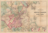
Map of Boston and the Country Adjacent, showing Rural Parks.
Building Out Boston.
- Digital Map Information
- Suitable for large format printing
- Full resolution TIFF file
- ICC color profile embedded
- Delivered instantly via download link
Building Out Boston.
This is a c. 1874 folding map of Boston, Massachusetts and environs published by Alexander Williams. It presents the city during a period when it was being completely reshaped by land reclamation, annexation, and industrialization.A Closer Look
The map presents the greater Boston area as far north as Saugus, Lynn, and Swampscott, as far south as Hingham and Cohasset, and as far west as Lexington, Waltham, Newton, and Needham. Individual towns are color-shaded for easy distinction. Impressive detail includes individual buildings in the suburbs. Roads, railways (including horse railroads), cemeteries, train stations, industrial works, waterways, educational institutions (including Harvard College), charitable and social institutions (including the Massachusetts General Hospital), and other features are recorded throughout. Portions of the Back Bay and South Boston are ghosted in, indicating that the reclamation work that created these neighborhoods was still underway. Although this map does refer to some parks, it does not represent the proposed park system developed by Ernest Bowditch, despite the title (see ' Publication History and Census ' below).Historical Context
This map presents Boston in a period when the city was being transformed by land reclamation, industrialization, and annexation of surrounding towns. The railroads crisscrossing the map reflect Boston's status as the rail hub for all New England, with lines feeding into North and South Stations, the basis for today's MBTA Commuter Rail system. As mentioned above, the map reflects ongoing land reclamation efforts, which would only intensify in the following years. Boston was also expanding by aggressively annexing surrounding towns, including Roxbury, Dorchester, Charlestown, Brighton, and West Roxbury between 1868 and 1874. This 'Greater Boston' vision ensured that the city maintained its tax base as the middle class fled the urban core for the quieter, rail-accessible periphery. Moreover, less apparent on the map but equally significant, Boston suffered widespread destruction in the Great Fire of 1872. Although tragic, the fire enabled the city to widen streets and modernize the downtown commercial district.Publication History and Census
This map was prepared and published by Alexander Williams in Boston. It is undated, but corresponds to dated maps from the early-mid 1870s, while Bowditch's career history suggests a similar date. It appears that Bowditch employed a modified version of an existing Williams map of Boston and environs (e.g., BostonCounties-wallingwilliams-1872) to illustrate his proposed parks. The Williams map went through several editions and printings, most not showing Bowditch's parks but some retaining that subtitle, as is the case here, for reasons that are unclear (for comparison, the Leventhal Map and Education Center at the Boston Public Library has digitized both the present map and the map of the same title showing Bodwitch's parks). In any event, the many iterations have been cataloged indiscriminately, making a true census difficult to establish.Cartographer
Alexander Williams (August 24, 1818 – January 11, 1900) was a Boston based bookseller and publisher active in the middle to late 19th century. Williams was born near Fort Hill, Roxbury, Boston in 1818, the son of an Episcopalian bookseller, and grandson of Captain Robert Williams. As a young man he was indoctrinated into the book trade by his father and uncle, then the largest booksellers in Boston, who operated under R. P. and C. Williams on Cornhill Square at 209 Washington Street. It is said that the Cornhill bookstore was a popular hangout for luminaries of the period, including Emmerson, Longfellow, Willis, Sargent, Holmes, and others. In 1832 Williams moved to New York in order to expand his knowledge of the book trade under Elam Bliss, a New York bookseller and publisher. In New York, Williams befriended Aaron Burr, J. Fennimore Cooper, Fitz Green Halleck, and Washington Irving, among others. Williams returned to Boston in 1840 to take a position with George W. Redding in the publishing and magazine distribution department of Redding and Company. By 1841, he had become a silent partner in the Redding firm setting up a magazine delivery service throughout New England. By 1855 the newspaper and magazine delivery service became so prosperous that the partners determined to split it off as the New England News Company, with Williams as the head and primary shareholder. Shortly thereafter, Williams left the New England News Company to work again with his father and uncle on Washington Street. In 1869, one of the most iconic bookstores in Boston, the Old Corner Book Shop (27-29 Bromfield Street) became vacant. Williams took it over, operating it until his retirement in 1869. In 1883, he dissolved the old Cornhill Shop, which was at the time a partnership consisting of Williams, C. L. Damrell, H. M Upham, and J. G. Cuppers. Williams lived at 139 Newbury Street, Boston. He died in 1900 of complications relating to pneumonia and advanced age. He was survived by two sons, Alexander Williams J. and Charles C. Williams, and one daughter. Further Details...
Condition
Good. Some wear on old fold lines with slight loss at fold intersections. Accompanied by original gilt stamped green linen binder.
References
OCLC 20908325.