
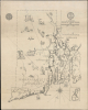
1925 Witherell Pictorial Historical Map of Rhode Island


This item has been sold.
A Map of the Colony of Rhode Island and Providence Plantations, 1636-1740.
Land of Hope.
- Digital Map Information
- Suitable for large format printing
- Full resolution TIFF file
- ICC color profile embedded
- Delivered instantly via download link
Land of Hope.
This is a 1925 pictorial and historical map of Rhode Island, prepared by Eugene E. Witherell for the Rhode Island chapter of the National Society of Colonial Dames. It presents the colony of Rhode Island as it existed in the late 17th century, a tenuous group of settlements inhabited by religious dissenters and at risk of attack from several directions.A Closer Look
The map covers colonial Rhode Island, labeling settlements, Native American groups, and topographic features throughout. 53 sites are numbered and explained in a key on the verso. Illustrations depict early colonial-era settlements, Native Americans, local wildlife, forests, and ships. An inset of Block Island appears at the bottom-right. Ships off the coast, which the verso indicates is a reference to the 'first American naval battle' in 1690 (during King William's War, 1688 - 1697) when English buccaneer Thomas Paine fought off a larger group of French privateer vessels.Aside from the threat of French attacks, the early colonial settlers had to manage relations with local Native American groups, particularly the powerful Narragansett. These relations were generally peaceful thanks to skilled diplomacy by the likes of Roger Williams, but went disastrously wrong in the run-up to King Philip's War (1675 - 1678), a brutal conflict that took a heavy toll on both the colonists and the Native American groups arrayed against them, particularly the Wampanoag, who were essentially eradicated.
Publication History and Census
This map was drawn by Eugene E. Witherell under the direction of Howard M. Chapin, the Librarian of the Rhode Island Historical Society, for the Rhode Island chapter of the National Society of Colonial Dames. It is noted among the holdings of 12 institutions in the OCLC and is also held by the Providence (John Hutchins Cady Map Collection) and Brownstown Public Libraries. We see no market history.Cartographer
Eugene E. Witherell (May 21, 1904 - December 14, 1987) was an artist, architect, and government administrator active up and down the East Coast of the United States in the 20th century. Witherell was born in Taunton, Massachusetts and attended high school in Attleboro, on the border with Rhode Island. After graduating, he attended the Rhode Island School of Design, where he met his wife, Beryl Wood, who worked as an arts educator in Fall River, Massachusetts, and with whom he had two children. Witherell's cartographic and artistic output was limited, with two known works, both historical, pictorial maps of Rhode Island from 1925, one separately issued and another appearing on the inside back cover of the 1925 book Our State Rhode Island by Lilian Burleigh Miner. Witherell also studied at the Beaux Arts Institute in New York and worked for a time as an architect in New York City before he and Beryl relocated to Virginia. He appears to have briefly worked as an architect in Virginia before joining the Federal Government's General Services Administration, rising to be Director of the Architectural and Structural Division of the Public Buildings Service. He helped design buildings of the National Institute of Health campus in Bethesda, Maryland as well as the backdrop of the Declaration of Independence and Constitution in the National Archives Building. Witherell also served in the U.S. Navy during the Second World War, rising to the rank of lieutenant commander. After retiring from the federal government, he and Beryl relocated to North Port, Florida near Sarasota. Further Details...
Condition
Average. Pinholes in corners. Closed edge tears. Closed tears extending 3 and 4 inches, respectively, through printed area professionally repaired on verso. Creasing. Text on verso.
References
OCLC 4572942.