
1928 Bodley Pictorial Map of Concord, Massachusetts

This item has been sold.
A Map of Concord. The Old Musketaquid Plantation.
Evokes the earliest history of Concord.
- Digital Map Information
- Suitable for large format printing
- Full resolution TIFF file
- ICC color profile embedded
- Delivered instantly via download link
Evokes the earliest history of Concord.
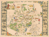
This is a 1928 Helen Bodley pictorial map of Concord, Massachusetts. The map celebrates Concord's Revolutionary War history and many surviving historic homes.A Closer Look
Coverage embraces the town of Concord, Massachusetts, blending the historical and modern. American Revolutionary War (1775 - 1783) references include a note near Peter's Field reading 'Birthplace of American Liberty April 19, 1775', the site where colonials ate breakfast the morning of the Battle of Lexington and Concord, and footprints marking the Colonial Army's path to intercept British soldiers at Merriam's Corner. A minuteman and a British redcoat glare at each other along the right side. Sites around Concord are identified as well, including the library, armory, and Concord Country Club. Branches of the New York, New Haven, and Hartford Railroad run through the area. Vignette views of historic houses and other important buildings create the left and right borders.The Musketaquid and Concord
The map's title references the 'Old Musketaquid Plantation.' Concord was founded in 1635 by English Puritan settlers led by Simon Willard and Rev. Peter Bulkeley, making it one of the earliest inland colonial towns in New England. The area was originally called Musketaquid - 'grassy plain' in Algonquian - was home to the Massachusett tribe, who agreed to a land transaction with the settlers, an unusually peaceful exchange for the time, which inspired the name 'Concord.' Well located at the confluence of the Sudbury and Assabet Rivers, the town became an agricultural hub and center of revolutionary activity. By the 18th century, Concord was immortalized as the site of the first battle of the American Revolutionary War on April 19, 1775 - a moment later celebrated as the 'shot heard 'round the world.'Publication History and Census
This map was created by Helen Bodley and published by the Houghton Mifflin Company in 1928. We note at least five institutional holdings: Buffalo and Erie County Public Library, the University of Minnesota at Minneapolis, the Norman B. Leventhal Map Center at the Boston Public Library, the David Rumsey Map Collection, and the University of Washington.Cartographer
Helen Gertrude Bodley (November 15, 1906 - January 19, 1997) was an American artist. Born in Boston to English immigrant parents, Bodley attended the Museum School of Boston. She published a pictorial map of Concord, Massachusetts, in 1928. In the summer of 1936 she was commissioned to paint portraits of the children at the Nursery Training School of Boston as a fundraiser for the school. She died in Seattle, Washington, on January 19, 1997. Little else is known about her life or her artistic career. Further Details...
Condition
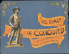
Very good. Light wear along original fold lines. Closed margin tears professionally repaired on verso, else excellent. Accompanied by original envelope which is in good condition (see image).
References
Boston Public Library, Leventhal Collection, 06_01_014642. Rumsey 13333.002. OCLC 13555112.