
1861 Bufford Map of the Concord and Sudbury Rivers, Massachusetts

This item has been sold.
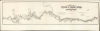
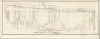
Plan of Concord and Sudbury Rivers, with the Meadows Adjoining. 1861. (with) Profile of the Concord and Sudbury Rivers 1861.
Inundated Meadowlands of the Concord River.
- Digital Map Information
- Suitable for large format printing
- Full resolution TIFF file
- ICC color profile embedded
- Delivered instantly via download link
Inundated Meadowlands of the Concord River.
This is J. H. Bufford's 1861 map of the Concord, Sudbury, and Assabet Rivers in Massachusetts, drawn from surveys made to assess the combined effects of various hydrographic projects on the meadowlands of those rivers. While the politician and lawyer D. W. Alvord oversaw the project, the work was undertaken by the renowned civil engineers Charles Storer Storrow and Joel Herbert Shedd.While nowhere credited, it is very probable that Storrow and Shedd's surveys were built upon the locally - produced surveys of Henry David Thoreau, (1817 - 1862) famed American essayist, poet, naturalist, and erstwhile surveyor.
A Closer Look
This elegant map, oriented just north of west, follows the course of the Sudbury River from Saxonville to its confluence with the Assabet River at Concord; from there, the river continues as the Concord River to Billerica Mills. Some tributary streams are also included, such as the West Brook (shown as far as Mill Village). Local bodies of water, such as Heard Pond and Baldwin Pond, are visible. Towns marked along the rivers include Saxonville, Wayland, Concord, and Billerica. Bridges are marked, as are shallow bars in the river. Particular attention is given to swamps and meadows along the rivers' edges. The map notes specific locations at which the surveyors took depth measurements.The map is attended by a second sheet, showing the rivers in profile and recording fluctuations in the depths of the rivers as measured at specific locations along their courses.
Charting Changes in the Rivers
These were published for inclusion in a Massachusetts state government publication, 'Report of experiments and observations on the Concord and Sudbury Rivers in the year 1861.' The report presented the results of a study prompted by complaints, brought before the state in 1860, that rising river levels had inundated the seasonal hay meadows on their banks, with catastrophic effects for the agriculturalists of the river valley. The flooding was thought to be caused in part by the damming of the Concord River to feed the Middlesex Canal, and in part by the maintenance of new reservoirs built to water Boston. Numerous lawsuits against the canal proprietors were filed but were unsuccessful, partly due to scientific uncertainty and partly to the political power of the mill, canal, and reservoir proprietors. 20th-century analysis suggests that the Billerica Dam had probably caused flooding of the hay meadows as far as 25 miles up the watershed, resulting in the abandonment of many of them. These are now wetlands.Publication History and Census
This map was lithographed by J. H. Bufford (reduced to 1/4 the size of the manuscript original) for inclusion in the 1862 'Report of experiments and observations on the Concord and Sudbury Rivers in the year 1861.' Thirteen examples of the report are listed in OCLC. We see examples of the separate map cataloged only by Harvard University and the State Library of Massachusetts. It is extremely rare on the market.Cartographers
John Henry Bufford (July 27, 1810 - October 8, 1870) was a Boston based lithographer and printer. Bufford was born in Portsmouth, New Hampshire. He apprenticed as an artist and lithographer at Pendleton Lithography (1825 - 1836) of Boston. In 1835 he relocated to New York where he took independent commissions from George Endicott and Nathaniel Currier, among others. Returning to his hometown of Boston in 1839, he took a position of chief artist with the firm of Benjamin W. Thayer, heir to Pendleton Lithography. He probably married Thayer's sister, Anna Melora Tufts Thayer (1808-1878). Bufford has been highly criticized as an engraver, with one historian, David Tatham, stating he had 'a mediocre sort of craftsmanship at best' and 'no very special skills as an original artist.' We, however, find no justification for this harsh criticism. Instead Bufford gravitated toward business and management. By 1844 Thayer's shop was renamed J. H. Bufford and Company. The firm specialized in decorative sheet music, panoramic views, illustrations for books, retractions of paintings, and commercial printing. Bufford is credited with being one of the first employers and mentors of the important artist and engraver Winslow Homer. Bufford died in 1870, passing on the business to his sons Frank G. Bufford and John Henry Bufford Jr. These young men, operating under the imprint of 'J.H. Bufford's Sons, Manufacturing Publishers of Novelties in Fine Arts', expanded the firm with offices in New York and Chicago. A possibly related lithographic printing firm named Bufford Chandler was incorporated in Boston in 1893. It later relocated to Concord, New Hampshire but closed in 1925 when its state business charter was repealed. Further Details...
Charles Storer Storrow (March 25, 1809 - April 30, 1904) was an American civil engineer. He is known for having designed the dam and textile mill complex of Lawrence, Massachusetts. He was born in Montréal and educated in Paris, where his father did business. He returned to America in 1824 to attend Harvard. After graduating in 1829, he again moved to Paris to study hydraulics. He brought his new expertise to America in 1832, where he joined the staff of the Boston and Lowell Railroad as an engineer. In 1845. Storrow became chief engineer at the Essex Company, a company organized to harness the water power of the Merrimack River. He would not only design and build the Great Stone Dam across the Merrimack, but he also built several textile mills there, along with a small city - Lawrence - to house their workers. He would become the first mayor of Lawrence in 1853. He had literally written the book on the mathematical theory of hydraulics: A Treatise on Water-Works for Conveying and Distributing Supplies of Water; he would author an array of reports on projects ranging from the Hoosac Tunnel to the impact of hydraulic projects on the meadows of the Concord River. Further Details...
Joel Herbert Shedd (May 31, 1834 - November 27, 1915) was an American civil engineer and surveyor. He was born in Middlesex, Massachusetts, and learned the surveyor's trade in a Boston office. He worked as a surveyor in conjunction with Charles S. Storrow. For much of his later career, he was City Engineer of Providence, Rhode Island, and was chairman of the Rhode Island Harbor Commission. In 1880, he became a founding member of the Providence Art Club and was a member of the advisory board of Brown University. He was broadly published; he was credited on several maps, but a wide array of reports of a technical nature on sewerage and drainage. He also applied his skills on a smaller scale, co-authoring an 1859 'Suggestions on landscape gardening.' Further Details...
DANIEL W. ALVORD (October 21, 1816 - August 3, 1871) was an American lawyer and politician. He was a graduate of Union College in 1838, and thereafter studied law under the tutelage of his father, uncle, and brother, all lawyers. He became district attorney of the Northwestern district in Massachusetts from 1856 to 1862. He was a member of the Massachusetts Constitutional Convention in 1853, and state senator in 1854. Further Details...
Source
Commissioners of Experiments and Observations on the Concord and Sudbury Rivers.,Report of experiments and observations on the Concord and Sudbury Rivers in the year 1861. (Boston: William White, printer to the State) 1862.
Condition
Excellent, untrimmed. Profile sheet with marginal mends not impacting image.
References
OCLC 57138463.