
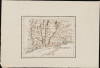
1833 A.J. Wetherell Miniature Schoolboy / Schoolgirl Map of Connecticut

Connecticut.
Could 'you' draw this map in 20 minutes?
- Digital Map Information
- Suitable for large format printing
- Full resolution TIFF file
- ICC color profile embedded
- Delivered instantly via download link
Could 'you' draw this map in 20 minutes?
This is a beautifully executed yet whimsical 1833 schoolboy / schoolgirl manuscript map of Connecticut, in a remarkably precise, miniature format. Signed by A. J. Wetherell and dated February 19, 1833, it may well have been executed from memory. Astonishingly, there is reason to suppose that the drafting of this beautiful map was a timed exercise, and that it took all of 20 minutes.A Closer Look
This painstakingly drawn map covers all of Connecticut and the northeastern coast of Long Island, including Fishers Island. County borders are highlighted in color. Mountains are presented pictorially. It features a few interesting points of local history, such as Devil's Den in Weston County. The Shaker community in Enfield, Connecticut, is noted. The source for the map is almost certainly an example of Anthony Finley's map of the state, based in particular on the distinctive pattern of the mountains in the western two thirds of the state, the specific use of the term 'Shakers' instead of 'Enfield' for that community, and for the use of the place name 'Lyndes Pt.' at the mouth of the Connecticut River. These features all combine to identify the Finley source, especially considering the likelihood that the map was drawn from memory. There are some errors that could be ascribed to memory. For example, the position of Manchester is occupied by the town of Oxford (in addition to the unrelated Oxford in New Haven County). Manchester was established in 1823, and appears as such on the Finley maps of Connecticut, but prior to that, it was Orford Parish of East Hartford.Wetherell
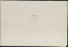
The verso of the map is signed 'A. J. Wetherell,' and dated February 19, 1833. The boy Wetherell - who may have gone on to become a veteran of some of the Civil War's most brutal fighting, surviving to a ripe old age also included a cryptic note beneath the date: '20 Mts'. In the note-taking conventions of 1833, the contraction 'Mts' generally refers to 'Minutes' - raising the speculation that this superb little map was executed as a timed exercise, from memory, in only 20 minutes. The drafting of maps under a time limit fits the pedagogical methodology for the period, but we have not encountered such a piece with its time limit so noted. (This writer, should he have been able to achieve such a feat, would certainly have printed the time much more boldly.)Schoolgirl (or Schoolboy) Maps
While the use of mapmaking in teaching is first seen in Europe, mainly England, the Schoolgirl Map became a peculiarly American pedagogical tool in the first part of the 19th Century, a period in which standards and purposes in women's education were changing. While boys were frequently taught the practical execution of surveys and charts, the production of attractive and informative maps appears to have been primarily the domain of young women. Such maps can be found of the world, the United States, or specific states. These were usually based on generally available reference maps, such as those found in the atlases produced by Carey and Lea, Finley, and Mitchell.The goals of these exercises were more far-reaching than teaching geography. Girls learned penmanship, with maps commonly incorporating three or more lettering styles. Mapmaking sharpened the retention and recall of factual information. Students were encouraged to take pains in their draftsmanship and often achieved beautiful flourishes of artistic expression. But most peculiar to the American iterations of educational mapping was the goal of instilling a sense of civic pride and responsibility. Indeed, the key desired result of the education of girls in the post-Revolutionary-War United States was to prepare for the education of the next generation of American citizens, a patriotic duty which would primarily fall on the shoulders of these young women.
For a good overview of Schoolgirl Maps, see Betty Mason's '19th Century Schoolgirls Were Incredibly Good at Drawing Maps.' Published July 27, 2016 by National Geographic.
Publication History and Census
This map is a unique manuscript.Cartographers
A. J. Wetherell (c. 1815 - c. 1900) was an American soldier, and possibly an engineer or carpenter, living and working in Connecticut. We know him only through his signature on a single manuscript map dated February 19, 1833. The date suggests a birthdate between 1815 and 1820. He appears to have lived mainly in Hartford County, in Manchester or New Britain. At the end of the 19th century, a carpenter named 'A. J. Wetherell' appears in the Manchester, Connecticut Directory. The New Britain, Connecticut City Directory of 1891 lists an Albert J. Wetherell as an engineer by trade. If either of these refers to our Wetherall, he lived long! An 'Albert. J. Wetherill, alias Joseph A. Wetherell' served as an enlisted man in the Connecticut Infantry during the Civil War, notably with the Connecticut First Infantry. This unit, made up of Hartford County volunteers, fought with distinction at the First Battle of Bull Run. He served in the 8th Connecticut Infantry for the rest of the war, mustering out on December 12, 1865, having survived Antietam, the Second Battle of Fredericksburg, and the Siege of Petersburg. If this Wetherell is the same as ours, these achievements are more remarkable considering that in 1861, he would have been a venerable 43 to 46 years old. Further Details...
Anthony Finley (August 25, 1784 - June 9, 1836) was an American book and map publisher based in Philadelphia, Pennsylvania. Finley was born in Philadelphia in 1784. He opened a bookshop and publishing house at the Northeast corner of Fourth and Chestnut Street, Philadelphia in 1809. His earliest known catalog, listing botanical, medical and other scientific works, appeared in 1811. His first maps, engraved for Daniel Edward Clarke’s Travels in Various Countries of Europe, Asia, and Africa also appear in 1811. His first atlas, the Atlas Classica, was published in 1818. He soon thereafter published the more significant A New American Atlas and the New General Atlas…, both going through several editions from 1824 to 1834. Although most of Finley's cartographic material was borrowed from European sources, his atlases were much admired and favorably reviewed. In addition to his work as a printer, Finley ran unsuccessfully on the 1818 Democratic ticket for Philadelphia Common Council. He was a founding officer of the Philadelphia Apprentices’ Library, and a member of both the American Sunday-School Union and the Franklin Institute. He was also an ardent supporter of the American Colonization Society, an organization dedication to returning free people of color to Africa - which led to the founding of Liberia. Much of his wealth was dedicated to supporting this cause. Finley was active as a publisher until his 1836 death, apparently of a 'lingering illness.' Shortly thereafter advertisements began appearing for his map business and plates, most of which were acquired by Samuel Augustus Mitchell. Further Details...
Condition
Fine. Manuscript with original outline color. Generous margins on wove paper. Whatman 1829 watermark.