
1955 Mathis Pictorial Map of U.S. Route 40, Donner Pass, California and Nevada

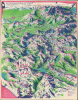
Donner 'U.S. 40' Follow the Route of the Old Donner Trail... Along Famous U.S. Highway 40. Fun Map, Donner Ski Trails for Winter Sports, Road Map for Summer Fun
From Emigrant Trail to Expressway.
From Emigrant Trail to Expressway.
This is a c. 1955 George Mathis pictorial map of U.S. Route 40 and environs in California and Nevada. Passing through California's former gold country and near the scenic beauty of Lake Tahoe, the highway's route also had a darker history, following the path taken by the ill-fated Donner Party in 1846-47.A Closer Look
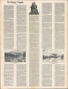
Oriented towards the east, the map covers the Sierra Nevada Mountains from a point northeast of Sacramento to Reno, focusing on the route of U.S. 40, now Interstate 80, itself largely following earlier emigrant routes. Multiple references are made to the history of the Donner Party (discussed below), which gave its name to the high pass through the mountains, and to the importance of this region to the California Gold Rush of the late 1840s and 1850s. Other illustrations and references relate to the 'fun map' facet of the subtitle, with a dozen ski areas numbered and indications of prime areas for fishing, hunting, and horseback riding. The verso contains an extensive history of the Donner Party tragedy.Historical Context
U.S. Route 40's track across northern Nevada and eastern California closely followed the historic paths forged by 19th-century pioneers traversing the Great Basin and the Sierra Nevada. The pass earned its infamous name following the tragic winter of 1846-47, when the ill-fated Donner Party became trapped by early, severe blizzards near Donner Lake, resulting in the deaths of nearly half their group. Following the surge of migration during the California Gold Rush, this treacherous mountain passage was improved into the Dutch Flat and Donner Lake Wagon Road in the 1860s, establishing the summit as the primary overland entry point into northern California.In 1913, these wagon paths across Nevada's high desert and California's mountain passes were incorporated into the Lincoln Highway, before being officially designated as U.S. Route 40 in 1926. Stretching from the Utah border through Reno, over Donner Summit, and down through the Sacramento Valley to San Francisco, US 40 became a major transcontinental artery, though negotiating its narrow, winding turns near the summit remained notoriously dangerous during winter months. By the 1960s, the demands of modern traffic led to the construction of Interstate 80, which largely incorporated the existing highway but bypassed the steepest, most perilous stretches of old U.S. 40 around Donner Summit. Today, surviving scenic segments of original U.S. 40, including the landmark Rainbow Bridge near the pass, stand as historic monuments to both the tragedy of early westward expansion and the engineering triumphs that eventually bridged the continent.
Publication History and Census
This map was prepared by artist George Mathis around the year 1955 and issued by Trip Teaser. It is only noted in institutional collections at Stanford University (the David Rumsey Historical Map Collection) and the Newberry Library.Cartographer
George Mathis (January 26, 1909 - September 28, 1977) was an American artist. Born in Seattle, Washington, Mathis suffered from Paget's disease as a child which led to him spending much of his time indoors. During these years Mathis developed an interest in art and his early art education was self-taught. After graduating from high school Mathis attended Washington State University, where he studied landscape painting under William T. McDermott and majored in art. He graduated in June 1932, moved to California, and began working as a commercial artist and art teacher. Mathis married his wife Jean in 1936. He and his wife Jean moved to Nevada City, California, in 1948 after living in the Bay Area for a few years. Here Mathis developed his desire to use art to recreate western history. During this time Mathis also began doing lithography, which soon led to a very successful business. The couple moved to Coloma, California, around 1960, and remodeled a Victorian-style house dating from the Gold Rush era. They operated a studio and art gallery here and named their home 'Friday House', using Jean's maiden name. Mathis' passion for recreating the Gold Rush era earned him the nickname 'pictorial historian of the Mother Lode'. He added a new dimension to his career in the 1960s, when he began creating illustrations for the Aerojet Corporation, the Sacramento-based aerospace company, then America's largest producer of rocket engines. Further Details...
Condition
Excellent.
References
Rumsey 8579.001. OCLC 953572899.