
1945 Cooke Geologic Map of Florida

This item has been sold.
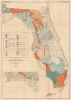
Geologic Map of Florida.
Florida's unique geology.
- Digital Map Information
- Suitable for large format printing
- File Size: 33.94 MB
- File Type: ZIP / TIFF
- ICC color profile embedded
- Delivered instantly via download link
Florida's unique geology.
This is a 1945 C. Wythe Cooke geologic map of Florida. Cooke was an accomplished geologist who published numerous books and articles on the subject.A Closer Look
Coverage embraces peninsular Florida east of the Apalachicola River, with an inset in the lower left corner illustrating the panhandle from the Apalachicola River west to Alabama. Color combinations and motifs highlight 22 geologic formations: the Pleistocene Series (6 formations), the Pliocene Series (7 formations), the Miocene Series (5 formations), and the Oligocene Series (4 formations). A legend in the Gulf of Mexico details the shading used to highlight formations and includes characteristics of each.Aside from geological information, cities and towns are labeled and counties identified. The railroad network is also illustrated in detail, with each railroad line labeled.
Publication History and Census
This map was created by C. Wythe Cooke and published by the Florida Geological Survey in 1945. An example of the map is part of the collection of the Touchton Map Library at the Tampa Bay History Center. The map and the associated report are both well-represented in institutional collections, but scarce on the private market, with the map rarely appearing with the report, as here.Cartographer
Charles Wythe Cooke (July 20, 1887 - December 25, 1971) was an American geologist, paleontologist, and stratigrapher. Born in Baltimore, Maryland, Cooke attended Johns Hopkins University, where he earned a Bachelor of Arts in 1908 and a Ph.D. in geology in 1912. He held his first job with the U.S. Geological Survey in July 1910 (while he was a graduate student at Johns Hopkins) as a Junior Geologist for the U.S.G.S.'s summer work. He joined the U.S.G.S. in 1913 until 1956, when he retired from the U.S.G.S. on November 30, 1956. That same year, he became a research associate with the Smithsonian, a position he held until his death. Cooke published numerous works, including several maps, from 1914 until his last in 1969. Further Details...
Source
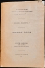
Cooke, C.W., Geological Bulletin No. 29 Geology of Florida, (Tallahassee, Florida: Florida Grower Press) 1945.
Condition
Good. Wear along original fold lines. Verso repairs to fold separations and at fold intersections. Closed .5 inch tear between Florida and the Florida Keys professionally repaired on verso. Accompanied by original government report in fair condition - dampstaining and back cover detached.
References
Tampa Bay History Center, Touchton Map Library L2018.087.022. OCLC 12569035.