
1952 Ichijo Map of the Island of Hawaii / Hilo

This item has been sold.
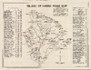
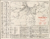
Island of Hawaii Road Map / City of Hilo.
Big Island on the Eve of Statehood.
- Digital Map Information
- Suitable for large format printing
- Full resolution TIFF file
- ICC color profile embedded
- Delivered instantly via download link
Big Island on the Eve of Statehood.
This is a 1952 Bungo Ichijo double-sided road map of Hawaii's Big Island and street plan of Hilo, issued for motorists through a collaboration of local civic promotion and commercial tourism. It serves as an early example of tourist potential amid a stunning and potentially hazardous landscape defined by active volcanoes. As a case in point, the map preserves the roads and visitor attractions of Kapoho and Kalapana before their destruction by later eruptions.A Closer Look
The map organizes the island around its encircling Belt Road, with the Hilo Post Office serving as the starting and finishing point of an extensive mileage table. Separate columns allow travelers to follow the circuit in either direction, via Hamakua or Kau. The itinerary measures a working landscape through post offices, plantation stores, schools, ranch gates, hotels, and road junctions. Additional tables explain the branch roads district by district, including access to beaches, waterfalls, mountain routes, and Hawaii National Park.The interior is dominated by hachured representations of Mauna Kea, Mauna Loa, Hualalai, and the Kohala Mountains. Saddle Road crosses between the great central volcanoes, while truck trails, the Stainback Highway, and a dashed Hilo-Kona Road extend the transportation network beyond the coastal circuit. Kulani Prison, Kilauea Military Camp, sheep stations, and former Civilian Conservation Corps camp locations appear alongside recreational destinations. Outlined and textured lava fields mark volcanic activity; particularly conspicuous are the flows dated 1950 on Mauna Loa's southwestern flank, recording the eruption of June 1-June 23, 1950, which sent three flows across the island's main highway before they reached the ocean. The accompanying touring notes recommend roadside examination of lava and explain the difference between smooth pahoehoe and rough aa.
The verso provides a detailed street plan of Hilo keyed to an alphabetical index through a letter-and-number border. Schools, hospitals, hotels, wharves, quarries, and the municipal golf course supply practical landmarks. Three inset plans continue the coverage around Wainaku, the eastern shoreline near Lehia Park, and the Uhaloa Road neighborhood. The airport's prominence is especially timely: General Lyman Field returned to civilian control on April 8, 1952, and construction of a new passenger terminal began that July. The touring notes on the verso direct visitors to Hilo's bulk sugar installation, a factory making insulating wallboard from sugar-cane residue, commercial orchid and anthurium growers, and a Kona coffee mill. A lauhala craft shop staffed by rehabilitated tuberculosis patients joins museums, churches, royal sites, and golf courses in the recommended itinerary.
Several recommended destinations now belong to a vanished landscape. Kapoho appears as a village with a school, nearby cinder cones, and access to warm springs; most of the village was destroyed in 1960. Kalapana and its celebrated black-sand beach are likewise presented as accessible touring destinations, decades before lava overran the community in 1990.
Publication History and Census
The island map is signed as traced by Bungo Ichijo on March 20, 1952. The Hilo plan separately credits Ichijo as preparer and states that it was issued by the Hilo Junior Chamber of Commerce. The map was presumably sponsored by the Kailua Motel and the Hilo-Kona U-Drive Company, identified with Aloha Aina Tours, Ltd., highlighted in red on the recto and verso, respectively. A map with this title was published between 1949 and the early 1970s (later editions undated), though only this edition credits Ichijo. All editions are quite rare in institutional collections, and the only cataloged example of this 1952 edition is with the Newberry Library.Cartographer
Bungo Ichijo (December 12, 1899 - December 8, 1980), born 'Bungoro Ichijo,' was a longtime resident of Hilo, Hawaii and a civil engineer employed by Hawaii County. Ichijo was born in Waiākea (Hilo) and married May Mika (Omika), also of Hilo, sometime in the early 1920s and had two daughters. Ichijo had a long career as an engineer - draughtsman with the county, beginning no later than 1925 (when he appeared as a draughtsman for the county in a directory), producing several road maps of the Island of Hawaii in the 1950s. Further Details...
Condition
Excellent.
References
OCLC 1032007086. Finch, R. H. and Macdonald, G., Hawaiian Volcanoes During 1950, U.S. Geological Survey Bulletin 996-B (1953), p. 27. Tilling, R., Heliker, C., and Swanson, D., Eruptions of Hawaiian Volcanoes - Past, Present, and Future, second revised edition, U.S. Geological Survey General Information Product 117 (2010), p. 51.