
1956 Florida Realty Bureau Promotional Map of Highlands County, Florida

This item has been sold.
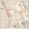
Sectional Map of Highlands County Florida Showing Location of Highlands Park Estates / Facts Folder and County Map for Highland Park Estates.
Promoting Florida's Interior.
Choose a Collection:
This Item
Enquire
Promoting Florida's Interior.
This is a 1956 Florida Realty Bureau promotional map of Highlands County, Florida, advertising the Highlands Park Estates housing development. The map and development serve as an important reminder of the extent of Florida's Postwar population and property boom, that reverberated well into the interior of the state, into previously sparsely inhabited areas.A Closer Look
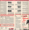
The map covers Highlands County, divided by survey lines into numbered blocks, with the Highlands Park Estates housing development shaded red and the development's public beach and property office indicated. Towns and other developed areas, such as an industrial area around Sebring Airfield, are outlined. Highways are traced and waterways are labeled throughout, including 'Highlands Lake' (Lake Istokpoga) adjacent to the development. Five insets appear, depicting, in turn, Sebring, highlighting the location of the Florida Realty Bureau office there, a map of Florida pointing out the location of Highlands County, and three plans of the towns of Avon Park, De Soto City, and Lake Placid. The verso includes text and images promoting the Highlands Park Estates development in particular and of Florida more generally. The map is also accompanied by a promotional letter sent to its original owner by the Florida Realty Bureau.Promoting Florida's Interior
When this map was produced, Highlands County was still relatively young, having been created in 1921 from portions of neighboring counties. While Florida's coasts, especially around Miami and Tampa Bay, saw rapid bursts of growth in the 1920s and again after World War II, the state's often remote, swampy, and inaccessible interior generally did not. However, Highlands County's relatively high elevation, cheap land, and highway access to the coasts made it a good candidate for spillover growth as land on the coasts became more expensive. Although Highlands Park Estates did not exactly become the next Palm Beach, the planned development site and nearby areas along U.S. Route 27 did see steady population growth in the Postwar period, roughly fifty percent per decade, that continued into the early 21st century.Publication History and Census
This map was prepared by the Florida Realty Bureau, managing agents of the development, in 1956. We have only been able to locate one other example of this promotional map, a 1958 edition held by Columbia University (miscataloged as 'Highland' rather than 'Highlands' Park Estates). The OCLC (1457976094) also notes one example of a 1959 edition of the base map, originally prepared in 1939 by W. H. Percy and Roger E. Miller and updated thereafter.Condition
Very good. Light wear along original fold lines. Text on verso.
References
OCLC 1430225297 (1958 ed.).