
1939 Zink Pictorial Tourist Map of Jacksonville, Florida, and Environs

This item has been sold.
What to Do What to See in and near Jacksonville Florida.
Enjoy exploring Jacksonville!
Choose a Collection:
- Digital Map Information
- Suitable for large format printing
- Full resolution TIFF file
- ICC color profile embedded
- Delivered instantly via download link
This Item
Enquire
Enjoy exploring Jacksonville!
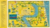
This is a 1939 first edition 'Zink' pictorial tourist map of Jacksonville, Florida, and its environs. Charming pictorial vignettes fill the sheet and highlight sites within Jacksonville and farther afield, even as far away as St. Augustine.A Closer Look
Downtown Jacksonville occupies the center of the sheet, with streets illustrated and labeled and a handful of locations are identified, including Confederate Park, Hemming Park, the Pose Office, the Tourist Bureau, and the Federal Reserve Bank. Outside the depiction of downtown, vignettes highlight the stadium, the municipal docks, the fruit and vegetable market, and the industrial park. Even farther afield, several other sites are marked, including farms and orange groves, Atlantic Coast beaches, and even other cities, such as St. Augustine. Distances from Jacksonville to tourist sites and other cities are provided outside the left border along the edge.Publication History and Census
This map was drawn by an artist known only as 'Zink' and published in 1939. We have identified 3 states. The present state includes Zink's signature, which is dated 1939, suggesting it is likely the first edition. Subsequent states are undated and have different verso content. Both undated states are part of the Touchton Map Library at the Tampa Bay History Center (2019.005.006 and 2018.080.028).Condition
Good. Wear along original fold lines. Loss along centerfold where previously stapled.