
1973 Joshua Tree Natural History Assoc. Map of Joshua Tree National Monument

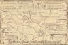
Joshua Tree National Monument. / Maps of Joshua Tree National Monument, California Regional Information and Major Hiking Trails.
Otherwordly Land of Inspiration and Wonder.
$250.00
Choose a Collection:
This Item
Enquire
Otherwordly Land of Inspiration and Wonder.
A curious 1973 map of Joshua Tree National Monument (now a national park), prepared by the Joshua Tree Natural History Association.A Closer Look
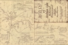
Employing coloration and motifs reminiscent of the area's desert landscape, the map covers the national monument and its surroundings. Within the federally protected land, roads, trails, springs, oases, ranger stations, and attractions are noted (in accordance with a legend at the bottom right). Palm Springs appears at left, and Twentynine Palms with its Marine Corps base at the top. Highways, including state routes and Interstate 10, are labeled. On the right are brands of some of the larger nearby ranches, while on the left are symbols associated with Native American groups. At the top are historical notes and the origin of the term 'Joshua Tree.' On the verso are smaller maps of different areas of the park, including the Wonderland of Rocks, Lost Horse Valley, and Cottonwood Spring.Publication History and Census
This map was prepared in 1973 by the Joshua Tree Natural History Association (founded in 1962), which later transformed into the Joshua Tree National Park Association, a partner organization of the National Park Service. (Joshua Tree National Monument became a National Park with the California Desert Protection Act of 1994.) The cover is signed 'PMB,' while the name 'D.M. Black' appears on the recto map. (Black was a park ranger at the time of the map's production.) The map is rare, with only one example appearing in OCLC: University of California Santa Barbara.Condition
Very good. Slight loss at the fold intersection.
References
OCLC 966686239.