
1940 Suchy Hand-Colored Limited-Edition Pictorial Map of Key West, Florida



This item has been sold.
Cayo Huesco / Key West Florida.
Signed, Hand Colored, 'Collector's Edition'.
Signed, Hand Colored, 'Collector's Edition'.
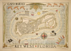
The most spectacular and desirable pictorial map of Key West, Florida, from the Golden Age of American Pictorial Maps, here in a 1940 'Collector's Edition' signed, numbered, and hand colored by artist Arthur B. Suchy. These Collector's Editions are exceedingly rare, having only been made in 100 examples (if that); signed and numbered examples are even scarcer.A Closer Look
The map covers all of Key West. City blocks are illustrated with important hotels, parks, trees, tourist attractions, and civic buildings numbered and keyed to lists surrounding the map: in all, more than 59 locations. The whole is surrounded by an elaborate border featuring decorative palm fronds and sea birds. Marine life and pirate historic ships populate the seas.Vignette text blocks celebrate Key West's past (pirates), present (the Overseas Highway), and future (the 'short route' on the Pan-American highway). The Overseas Highway reached Key West in 1938, two years before this map was issued, and ushered in a new era of prosperity for Key West as a tourist destination and retreat from Miami. The Pan-American Highway, which in the mini-map here connects Washington with Rio de Janeiro, was a bold project that never fully manifested, though parts remain in operation today. At the time, it was predicted that a secondary route, incorporating ferries between Key West, Havana, and the Yucatan, might open, but the Cuban Revolution (1953 - 1959) put an end to this dream.
Publication History and Census
This map was published in 1940 by Arthur B. Suchy in Cleveland, Ohio. There are two editions, the first, as here, known as the 'Collectors Edition', is about 30% larger, and was issued as a limited run of only 100 examples, each with hand coloring by Suchy. The earliest of these are numbered - the present example being 9/100 - and signed by Suchy. This is a practice that Suchy abandoned after the first few were completed. Possibly intimidated by the onerous and repetitive task of hand-coloring 100 maps, he abandoned the project or outsourced the colorwork. It is uncertain how many of the original 100 survived (or were actually produced); certainly, only a small fraction; most are not numbered or signed. We see examples of the first edition in the David Rumsey Collection and at the Touchton Collection at the Tampa Bay History Center, neither of which is numbered or signed. The second editions, easily distinguishable as they are printed in red ink, are common.Cartographer
Arthur Bartholomew Suchy (1901 - 1995) was a 20th century commercial artist, illustrator, and pictorial mapmaker. Suchy was born in Cleveland, Ohio and studied at New York's Colgate University from 1919 to 1923, where he distinguished himself as a student politician, athlete, and sportsman. His career as an illustrator and commercial artist spanned more that 50 years, but he was most active as a mapmaker between 1920 and 1940. Other than his map of Colgate University, most of his work focuses either on his native Ohio or his adopted home, Florida. Suchy's corpus is small but striking. His first map depicts his alma mater, Colgate University (1927). In the same year he issued a similar map of Swarthmore College (1927). This is followed by his large map The Heart of Cleveland (1928). He seems to have taken a 6-year break from pictorial mapmaking to focusing on his commercial career, but issued a new pictorial map illustrating his adopted home, Miami, in 1935. A second map of Cleveland, intending to illustrate the city as it appeared in 1836, was issued in 1937. This was followed by a general map of Ohio,Buckeye State issued in 1939. His final map, illustrating Key West, appeared in 1940. Some of his latter maps, particularly his Key West map, appeared in both hand-colored 'limited edition' formats and uncolored editions for the mass market. Further Details...
Condition
Very good. Laid down on linen. A few minor margin repairs.
References
Rumsey 9080.000. Tampa Bay History Center, Touchton Map Library, #2019.051.001. Hornsby, S. J., Picturing America: The Golden Age of Pictorial Maps, page 150, plate 71.