
1903 Kenyon Promotional Pocket Map of Louisiana

Map of Louisiana.
Shipping and Speculation.
$300.00
Choose a Collection:
- Digital Map Information
- Suitable for large format printing
- Full resolution TIFF file
- ICC color profile embedded
- Delivered instantly via download link
This Item
Enquire
Shipping and Speculation.
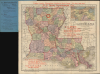
This is an unrecorded 1903 Kenyon Company pocket map of Louisiana, produced as a promotional piece for the E. C. Drew Investment Company. The map and promotional text reflect the prevalence of railroad and land speculation in the southern U.S. at the time.A Closer Look
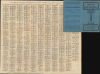
Coverage includes Louisiana with portions of neighboring states. Parishes are color-coded with congressional districts outlined and numbered, and cities, towns, rail lines, waterways, and terrain are noted throughout. The density of rail lines is noteworthy, as the repair of existing lines and construction of new lines were key elements in the postbellum Southern economy, in which New Orleans played a crucial role. An inset of New Orleans appears at the top right, while red promotional text for the E. C. Drew Investment Company appears at various points and on the cover. A grid surrounds the map, corresponding to a list of towns and cities on the verso with their populations.The E. C. Drew Investment Company
This map includes promotional overprint and advertisements on the cover for the E. C. Drew Investment Company in Monroe, the parish seat and largest city in Ouachita Parish, Louisiana. Although primarily invested in land and timber in northern Louisiana, Drew was nothing if not ambitious, with an office in St. Louis, interests in railways, and an agent in Dallas dedicated to the Texas and Pacific Railway (which did not go anywhere near Louisiana or St. Louis but which, like the Missouri Pacific and Iron Mountain Railway, was part of Jay Gould's railroad empire and was later merged into the Missouri Pacific).All these ventures might have overextended the E. C. Drew Investment Company or caused it to engage in questionable practices, as they were sued multiple times, including in one case that reached the Louisiana Supreme Court. In any event, the company looks to have gone out of business before the real windfall came to Ouachita Parish, when in 1916 a massive natural gas field was discovered at Monroe, making the city the 'natural gas capital of the world' and nearly doubling the city's population over the next decade.
Publication History and Census
This map was prepared by the Kenyon Company in 1903. We have not located another example from this year or the adjacent years in institutional collections or on the market; the nearest date is a 1911 edition held by the University of California, Los Angeles. It is likely the earliest map of Louisiana produced by the Kenyon Company.Cartographer
The Kenyon Company, Map Makers (fl. 1874 - c. 1930) was an American printing and publishing firm based in Des Moines, Iowa. The company published maps, atlases, and books, and advertised their high-grade calendars in the Des Moines Tribune. Further Details...
Condition
Very good. Slight wear on old fold lines.
References
OCLC 993607355 (1911 ed.).