
1940s Manuscript Pictorial Map of Mannhattan, New York City, by the Mattimores

This item has been sold.
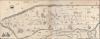
Manhattan by the Mattimores.
Playful hand drawn celebration of Manhattans's diverse entertainments.
Choose a Collection:
- Digital Map Information
- Suitable for large format printing
- File Size: 61.98 MB
- File Type: ZIP / TIFF
- ICC color profile embedded
- Delivered instantly via download link
This Item
Enquire
Playful hand drawn celebration of Manhattans's diverse entertainments.
A remarkable c. 1940s manuscript pictorial map of Manhattan, New York City, drawn by or for the Mattimore family. It is unclear who the Mattimores were, but we believe the happy family of three is illustrated at the center, in front of Rockefeller Center's Atlas statue.A Closer Look
The map is oriented to the northwest and covers Manhattan from the Battery to 125th Street. The whole is a pictorial tribute to New York, embracing its diversity of cultures, cuisine, monuments, and nightlife. We recognized the garment district, Hell's Kitchen, art in the West Village, the Financial District, Columbia University, Fulton Fish Market, the Theater District, and Harlem's vibrant lindy hop swing scene. Ethnic neighborhoods celebrated included Chinatown, Little Italy, Little Ukraine, and German immigrants in Yorkville. A man on 3rd Ave between 34th and 42nd appears to be coming off of quite the hangover. The title, set in the lower left on a classical plinth, can easily be misread as the 'Mallimores,' but close examination shows the 'l's to be 't's. Mattimore is a reasonably common name of Irish origin.Publication History and Census
This map is a unique manuscript. The artist is, unfortunately, unknown, as are the Mattimores.Condition
Good. Some soiling and glue discoloration at center - where two sheets are joined.