
1931 Bell Pictorial Historical Map of Minnesota

This item has been sold.
Historical Map of the State of Minnesota (The Land of the Cloud-Tinted Water).
Rare pictorial map of Minnesota.
- Digital Map Information
- Suitable for large format printing
- Full resolution TIFF file
- ICC color profile embedded
- Delivered instantly via download link
Rare pictorial map of Minnesota.
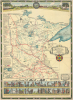
This is a 1931 Barbara Bell pictorial historical map of the State of Minnesota. Both visually striking and cleverly designed, it provides a comprehensive overview of the state's climate, ecology, and history from Native Americans to airplanes and automobiles. Stylistically, the map is clearly inspired by the work of Jo Mora, which it somewhat resembles.A Closer Look
The map covers the state of Minnesota, with rivers, lakes, railroads, Indian reservations, national forests, and contemporary (1931) cities noted. Historical sites such as forts, Native American villages, missionary stations, fur trading posts, roads, and frontier settlements are also labeled. Illustrations and text throughout refer to events, figures, and communities from the state's history, stretching back to the retreat of glaciers at the end of the last Ice Age, through Paul Bunyan, and down to the 20th century. Frequent references are made to the state's resources and modern economic output, from agriculture to mining to fishing. A band of text on the left provides brief historical timelines of the territorial history of the eventual state of Minnesota, the list of treaties with Native Americans that deprived them of most of their lands, the location and founding dates of religious missions, the dates and leaders of expeditions of exploration seeking the headwaters of the Mississippi River (ultimately found to be Lake Itasca, marked here with a merman and labeled 'Father of Waters'). Small inset maps cover Duluth and Minneapolis-St. Paul in more detail. Particular attention is paid to the history of Native Americans and the gradual encroachment of White settlers. Even though, the terminology sounds antiquated ('Primitive Indians still live here in their tribal state'), the sentiment towards Indians is generally sympathetic.Bands of illustrations cover the top and bottom of the sheet. At the top, to the left of the state seal is a depiction of the progression of transportation in different eras, from canoes and dogsleds when time was 'reckoned by the seasons' to airplanes in the era when speed has become 'paramount.' To the right of the state seal are representations of the state's main industries and economic activities. Below are silhouette drawings of the prehistoric animals of Minnesota, followed by two rows of illustrations of important figures (19 men and 1 woman) and events in the state's history, along with associated timelines. It is here, in the colorful, floral border, that the strong influence of Jo Mora can be seen, an early sign of his wider impact on pictorial cartography.
Publication History and Census
This map was drawn by Barbara Bell with research contributed by Clara Searle Painter and was published in 1931 by the Minneapolis College Women's Club, the local branch of the American Association of University Women. There are at least two printings of the map, which can be distinguished by the address of the College Women's Club below the title. The present example is an early printing, when the group was located at an address on Groveland Avenue. A later printing lists their address as 2115 Stevens Avenue, where the club is still located, and can also be distinguished by facsimile signatures of Bell and Painter in the lower-right margin. Catalog listings generally do not distinguish between these printings, as the copyright date of 1931 is maintained on both.Cartographers
Barbara Bell (fl. c. 1911 - 1946) was an artist active in Minneapolis, Minnesota. The details of her life are difficult to establish due to the presence of multiple Barbara Bells in Minneapolis at the same time. It is clear that she attended the Minneapolis Institute of Arts (now the Minneapolis College of Art and Design), where she won several awards, between roughly 1911 and 1915. She appears in Minneapolis city directories as an artist until 1946, while a 1928 newspaper article discussing a gallery display of her portraits of children describes her as a 'portrait painter and art school administrator,' likely at her alma mater. She was also an accomplished musician and singer who was known to collect and perform old folk songs as well as her own compositions. She also appeared in musical stage performances. Bell was active in several women's organizations, including the Minneapolis College Women's Club, Minneapolis College Women's Glee Club, and the National League of American Pen Women. Her somewhat frequent mentions in the pages of the The Minneapolis Star dealing with 'women's interest,' including coverage a steamship tour around the world, would suggest that she came from a high society family. Further Details...
Clara Evelyn Searle Painter (December 29, 1887 - May 12, 1975) was a researcher and education advocate based in Minneapolis, Minnesota. She was also heavily involved in local education issues, serving as the President of the Minneapolis Council of Parent-Teacher Associations and Secretary of the Citizens' Committee on Public School Finance. Painter (then Searle) was born in Massachusetts and attended Mount Holyoke College but moved to Minnesota upon marrying Hobart K. Painter in 1919 (the couple had four children). She contributed research to the 1931 pictorial 'Historical Map of the State of Minnesota,' drawn by Barbara Bell and published by the Minneapolis College Women's Club. Her work on that map inspired her to publish the book Minnesota Grows Up with Anne Brezler, a school principal in Minneapolis. The book told the history of the state in a style that was interesting and entertaining for children, with line drawing illustrations by Jane McCarthy, an artist at the University of Minnesota Press, which published the book in 1936. Further Details...
The American Association of University Women (AAUW) (1881 - present) is an American non-profit organization that advocates for equality for women and girls through advocacy, education, and research. Founded in 1881 in Boston by Marion Talbot and Ellen Swallow Richards, that AAUW now has over 170,000 members and supporters, 1,000 branches, and 800 college and university partners. Originally known as the Association of Collegiate Alumnae, the AAUW has participated in many campaigns advocating for women. In 1887, a fellowship was created to support women's education. The organization donated money to the campaign to purchase a gram of radium for Marie Curie in 1919. During World War II, the AAUW worked to support displaced female scholars and began raising money on their behalf. Today, the AAUW sponsors many different programs and still supports women's education through scholarships, grants, fellowships, and other awards. They also support research, STEM education, and leadership initiatives. Further Details...
Condition
Very good. Minor repair, top bottom margins, center. Laid down on archival tissue.
References
Rumsey 8301.000. OCLC 9398198.