
1945 Nahl Pictorial Map of Monterey Bay and Environs, California

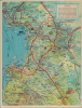
Cities of the Monterey Bay District California.
'The Most Alluring Spot in California.'
$250.00
Choose a Collection:
- Digital Map Information
- Suitable for large format printing
- Full resolution TIFF file
- ICC color profile embedded
- Delivered instantly via download link
This Item
Enquire
'The Most Alluring Spot in California.'
This is a charming c. 1945 pictorial map of the Monterey Bay region of California, prepared by Nahl Studios and printed by the Mysell-Rollins Bank Note Company. It depicts Monterey's rich economic bases and abundant recreational opportunities.A Closer Look
The map covers from the vicinity of Boulder Creek in the north to Big Sur and Soledad in the south, and as far inland as Hollister. Cities, towns, campgrounds, redwood forests, national forests and monuments, and other features are labeled throughout. Local produce, other economic products, and recreational activities are labeled, from grapes, lettuce, and fruit to hunting, fishing, and golfing. Roads, railways, shipping lines, and waterways are traced. Illustrations depict these various industries and activities, along with local landmarks such as the Del Monte Hotel and the 17-Mile Drive on the Monterey Peninsula, or the historic mission at San Juan Bautista. Andersen's Dahlia Farm is highlighted, with promotional text for the region at the top-right.Historical Context
At the time this map was produced, the Monterey Bay region was dominated by two industries: commercial fishing and industrial-scale agriculture. Monterey itself became the 'Sardine Capital of the World,' centered around the bustling industrial strip known as Cannery Row. During the peak of the 1930s and early 1940s, the canneries processed hundreds of thousands of tons of Pacific sardines annually, fueling a global export market and providing jobs for a diverse workforce of Italian, Portuguese, Japanese, and Chinese immigrants. The introduction of refrigerated rail cars in the 1920s allowed local growers in the Salinas Valley to ship lettuce, artichokes, and strawberries to East Coast markets, turning the fertile valley into a massive engine of agricultural wealth. However, this period also saw significant economic volatility and social unrest. Anti-immigrant sentiment was intense, particularly against Japanese, Filipino, and other Asian migrants who worked in the agricultural sector. The Great Depression brought internal migration ('Okies' and 'Arkies') as well as labor unrest to the fields and docks, and by the late 1940s, the sardine population collapsed due to overfishing and shifting ocean currents.Publication History and Census
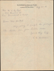
This map was prepared by Nicholas Nahl and printed by the Mysell-Rollins Bank Note Company, both of San Francisco. A handwritten note on the verso is dated August 29, 1945 (just days before the end of World War II, incidentally). However, the map may have been drawn significantly earlier, as Nahl's and the Mysell-Rollins Bank Note Company's other known, dated works significantly predate World War II. The map is reminiscent of a contemporary pictorial map of the region prepared by Ruth Taylor White for the L. and W. Land Company. (Previously sold by us as MontereyBay-whiteruthtaylor-1950.) We have seen other examples of that map with different companies' letterheads on the verso, and it appears that local chambers of commerce arranged for artists to produce promotional maps as an attention-grabbing backing for various farms' and companies' correspondence. The present map is quite rare, appearing only in the collections of the University of California, Berkeley (perhaps an earlier printing, dated 1930) and the Newberry Library. (The OCLC also notes Stanford University, but its own catalog does not include this map.)Cartographer
Nicholas V. Nahl (fl. c. 1922 - 1945) was an illustrator and printer based briefly in Oakland and then San Francisco, operating as V. Nahl Studios in the mid-late 1920s. The firm's output was limited and appears to have exclusively consisted of pencil-drawn bird's eye views. The published works of V. Nahl Studios ended around 1930, but Nicholas V. Nahl continued to appear in San Francisco city directories as a printer and 'press feeder.' Otherwise, the details of his life and work are elusive. Further Details...
Condition
Excellent. Handwritten letter on verso.
References
OCLC 943017801.